-2")
Warmer, but unsettled weather through the weekend
We’ll start off by saying this: Saturday will be the winner of the weekend, with highs in the 70’s even near the coast. The rest of the weekend, however, will remain unsettled. Multiple mid level disturbances crossing from the Central to Eastern United States, and the return of increased moisture, will lead to the chance of showers and rain both on Friday and Sunday afternoons. This leads to an uncertain temperature forecast, but increasing likelihood of unsettled weather both days will certainly hamper the weekend weather a bit.
Wednesday and Thursday, first, look to be exceedingly pleasant. Highs on both days will reach into the middle 60’s with generally light winds, and plenty of sunshine. If you’re headed to Madison Square Garden on Thursday afternoon and evening for the Rangers/Penguins Game 1 (we’re big Rangers fans here), the weather should be perfect. You might even be able to grab dinner outside or on a local rooftop restaurant before the puck drops at 7pm.
After high pressure gives way to a weak disturbance on Friday, which will bring increased clouds and chance of showers at times during the day, re-established high pressure will briefly take over on Saturday. West/northwest winds and warmer temperatures aloft will allow for highs to reach into the 60’s and 70’s during the afternoon hours on Saturday.
The wind direction becomes important for coastal locations. Often, this time of year, south or southeasterly winds can allow interior areas to warm up into the 70’s. But the coast feels the influence from cold ocean waters with that wind direction, and they often stay much cooler. West/northwest winds benefit all — as they come off the warmer land to our west and allow for the seabreeze to be mitigated. So Saturday looks like a winner — even down to the area coasts where temperatures may also reach into the 60’s and 70’s.
The unfortunate news is that by Sunday, another mid level disturbance will be approaching the area. This time, a stronger cutoff low over the Central United States looks likely to slowly trek eastward. Southerly winds will draw in moisture and enhanced lift will bring the likelihood of a period of steady to heavy rain from Sunday into Monday. The timing of this system will have big impacts on whether or not Sunday can be salvaged. But at the very least, it looks like increasing clouds are likely on Sunday with chances of rain increasing throughout the day.
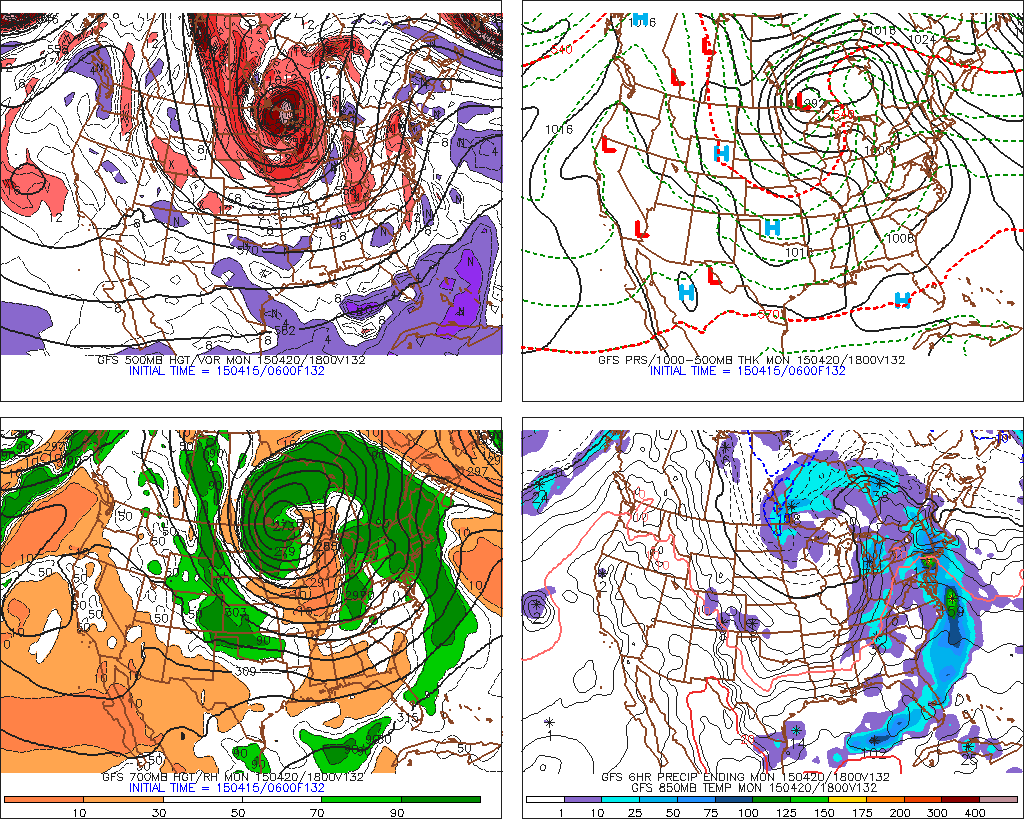
GFS model forecasting a period of heavy rain on Monday afternoon, associated with a large disturbance.
While still a ways out, models have come into better agreement in the medium range that the upper level low will be a decent-sized rain producer for our area. Most global forecast models show a period of enhanced moderate to heavy rain near our area on Monday afternoon. The aforementioned southerly flow looks likely to draw very moist air into the area — and when combined with enhanced lift, could produce a period of heavy rains on Monday. The exact details of this feature will have to be pinned down over the next several days.
Stay tuned, as always, and follow our social media accounts for up to the minute information. And for now, enjoy the beautiful weather!