-2")
Weekend Outlook: Warm, humid, scattered thunderstorms
Happy Friday! This week has closed out with some gorgeous spring-weather, with seasonable temperatures and a nice, light breeze. Additionally, after a humid start to the week, the second half of the week has featured very dry conditions.
As we head into tonight and tomorrow morning, clouds and humidity will gradually increase with the presence of a warm front. Before that, however, the rest of today looks quite nice with temperatures generally in the low 70s and partly cloudy skies. There will be an increased breeze along coastal areas as high pressure slides offshore and helps winds shift to southerly. These southerly winds will flow with the seabreeze, which adds to the overall wind speed in seabreeze-prone areas.
This evening will remain pleasant, though high clouds will gradually increase ahead of the warm front. The warm front will be moving in from the west and has plenty of Gulf of Mexico moisture on its warm side. While the front will cross the region at around midnight, there are some signs that it might get held up a bit by the residual high pressure system. As a result, model guidance is not forecasting a true increase in dewpoints until around 4-5:00am. Thus, we are holding off on mentioning showers until 3-5:00am or so. Temperatures will fall into the upper 50s, but may rise to the low 60s by daybreak.
Today’s NAM Model valid for 5:00am Saturday morning shows higher dewpoints and moisture convergence just beginning to move in. This is when we can expect some scattered showers.
The image above valid for 5:00am Saturday morning illustrates this quite well. The highest dewpoints/moisture is to our west and south, the warm side of the warm front, while very low dewpoints/dry air is to our north. It is not until 5:00am where we are even on the boundary of the true moisture increase, which is why we are holding off mentioning rain until this time or shortly before. Additionally, some moisture convergence is moving into the area at this time as well; though the highest is definitely away from the area.
Despite the warm air advection and the increase in moisture with the warm front, instability is still expected to remain meager through the overnight and through daybreak. This will limit the chances for thunderstorms, but a few showers with a burst of moderate rain is possible for much of the area. An isolated rumble of thunder is not out of the question, as there is a little bit of elevated instability.
Saturday: After a potentially wet late overnight/early morning, the mid-morning and early afternoon could have a period of clearing as the warm front itself pushes well north of the area. The warm front moving away will limit the lift, since the front itself is often a good source of lift. However, its warmer and more moist airmass will remain, and with the potential for plenty of breaks in clouds, temperatures could soar into the low to mid 80s with muggy conditions.
As the afternoon goes on, the lift in the atmosphere could return as a shortwave trough moves into the area with some vorticity (counterclockwise spin). Additionally, a slow-moving cold front will make its presence felt. These two features should be enough to create more lift in the atmosphere, and with the moisture and increased instability from the sunshine south of the warm front, scattered thunderstorms will be developing.

Today’s NAM valid for 5:00pm on Saturday shows a decent combination of instability, moisture, and wind shear to generate some strong thunderstorms.
While the parameters for severe weather don’t exactly jump out, there is a decent amount of “the big three”: 1) CAPE (Convective Available Potential Energy), which is approaching 2,000 J/KG in some locations, 2) Moisture: Precipitable Water, which measures the amount of moisture that would result if the atmosphere were to be squeezed out like a towel, is approaching 1.5″ and 3) Wind Shear: The Wind Shear from the surface to 500mb is generally around 30 knots, which is somewhat sufficient for storm organization and maintenance, though ideal values are closer to 50 knots. These are all borderline for severe weather. Additionally, we have some dry air in the middle of the atmosphere and moisture everywhere else — the best combination to generate a buoyant atmosphere and moisture that thunderstorms thrive in, but the dry air that helps bring down strong wind gusts and small hail.
Thus, it is possible that any thunderstorm would result in heavy downpours with flash flooding, 40-50mph wind gusts, and small hail. It will be harder to get these storms to sustain themselves as they approach Long Island, due to the colder Ocean waters limiting instability, but most areas away from the immediate coast will stand a decent chance of receiving a strong thunderstorm. While they will be scattered in nature, meaning that not everyone will get hit by a thunderstorm, the high moisture content should mean the storms will have decent coverage.
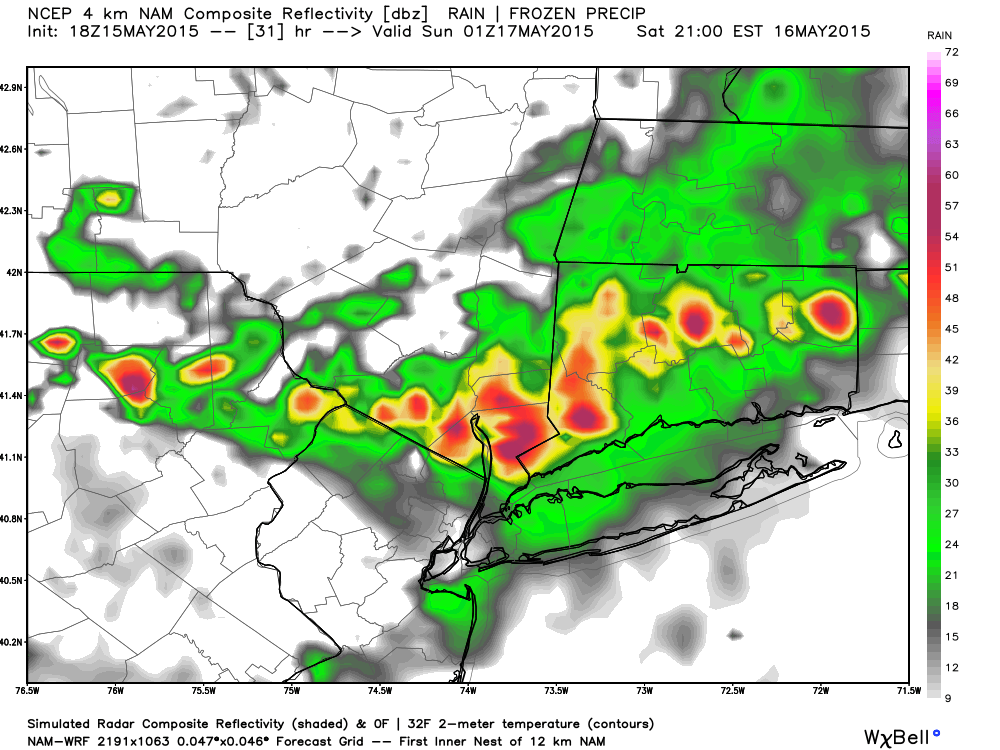
The chance of a thunderstorm will be best from 4:00pm through 8:00pm, with generally only a heavy rain threat afterward. The cold front will be slow to move through, so expect humid conditions and mild temperatures to linger on Saturday night. It will be wise to bring your umbrella if you are headed out. Temperatures should be holding in the mid 60s. It’s possible that a few localized areas could pick up over an inch of rain (with the rest generally a tenth to a half-inch), as the image below shows. This would be quite welcomed, given our recent drought.
Today’s NAM Model valid for Sunday afternoon shows low 80s for highs with a few scattered showers. It also shows that decent amount of rain has already fallen (bottom-right panel), indicating convectively induced heavy rain on Saturday and Saturday night (PSU-EWall).
Sunday is a bit of a tricky forecast. The cold front won’t completely clear the area, so moisture may still linger. However, wind shear will be almost non-existent, and mid-level flow is quite slow. This should mean that any thunderstorms should not get as intense as they do on Saturday, but they would also move quite slowly. Thus, heavy downpours with flash flooding are still possible in any thunderstorm, and localized flash-flooding could be even more of a threat due to the very slow movement of storms. That being said, the coverage of storms should not be as high, and there will be more sun than on Saturday. In fact, most areas may stay dry. Highs are again likely to be in the low to mid 80s.
Sunday night should dry out and be a bit chillier due to onshore flow returning and that cold front finally crossing the area. Monday will be a bit chillier as well, but the front will surge back northward as a warm front on Monday night and Tuesday, leading to more thunderstorms on Tuesday. Finally, a stronger cold front will cross on Tuesday evening, ushering in chillier air and ending the muggy regime.