-2")
PM Update: Pleasant evening, hot and stormy Thursday
Wednesday turned out to be one of the more beautiful days in the past several weeks. A transitional day, between disturbance, meant highs climbing into the lower 80’s with an abundance of sunshine. But more importantly, lower humidity and a lack of lift and atmospheric instability meant no thunderstorms or rain. Fair weather clouds were the only thing passing by — and the weather was extremely comfortable, even if the sun was a bit hot.
Wednesday evening, temperatures will remain comfortable and winds will continue westerly. This is important, as it negates any marine air or onshore flow (which kept us cool last week). To our north and west, a frontal system and wind shift boundary will move from the Great Lakes into the Northeast on Thursday. So while Wednesday Night will be pleasant and quiet, this boundary will be important for the coming day on Thursday.
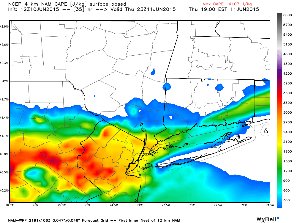
Prolific instability will exist across much of the area Thursday afternoon.
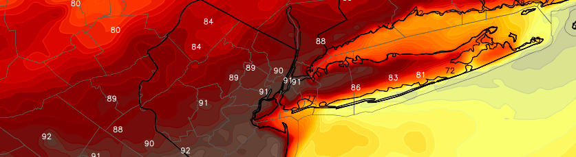
To the south of the aforementioned boundary, increasing mid level temperatures and west-southwesterly winds will pump up the temperatures by Thursday afternoon. Highs will rise into the 90’s and the air will feel much more humid and uncomfortable than it did on Wednesday. Accordingly, atmospheric instability will go up. Way up. CAPE values (Convective Available Potential Energy) will rise above 2500 j/kg during the afternoon, even above 3000 in some spots (these are high numbers for our area).
This obviously raises some eyebrows for the potential development of strong and severe thunderstorms. The question, then, becomes whether or not there will be enough atmospheric lift to trigger these storms. Thunderstorms need instability to develop, but they also need lift, forcing, or ascent to allow the updrafts to initially form. And then they need the right amount of atmospheric shear to mature and survive.
Thursday may very well be a “wait and see” day, as the mid levels of the atmosphere will be “capped” in some spots. This means that storm development will be somewhat mitigated initially, waiting for forcing to “force” the development of the storms. The most likely location for these storms to develop will be along a wind shift boundary, which will push southward from New England into the Mid Atlantic on Thursday afternoon. Prolific instability exists just south of this boundary, with northerly winds and stable air to its north.

Highs on Thursday afternoon will rise into the 90’s in many areas.
If updrafts do develop, storms could become severe quite quickly. A juicy and unstable atmosphere would support very heavy rain, dangerous lightning, and the potential for small hail and gusty winds in any storms. These storms would likely ride along the wind shift boundary from northwest to southeast as it pushes southward on Thursday afternoon.
For now, the Storm Prediction Center has placed our area in a “Marginal Risk” for severe thunderstorms, also citing the lack of lift for storm development as a potential mitigating factor. With the heat remaining the main story (it’s going to feel hot out there), we’ll have to keep a very close eye to the sky for any potential storm development on Thursday afternoon. Stay tuned!