-2")

T.S Erika, and her future over the next week
It is always interesting, this time of year, when a Tropical Storm or Hurricane forms to the east of the Lesser Antilles. While, obviously, no two meteorological patterns are exactly the same, tropical systems that form in this general area seem to have a tendency to catch the attention of those on the United States East Coast and Gulf Shores. It’s no surprise, really, given the history of such storms making landfall somewhere within the United States. An equal amount of systems, still, recurve “harmlessly” out into the open Atlantic Ocean or, in the case of Hurricane Danny just days ago, succumb to shear and unfavorable atmospheric conditions and die.
Tropical Storm Erika (with a “K”) formed last night in the Tropical Atlantic Ocean, with maximum sustained winds of around 45 miles per hour. Erika is expected to continue on a generally northwest heading over the next few days, gradually strengthening as she heads toward the Bahamas. Intermittently poor atmospheric conditions (albeit, no prolonged periods of strong shear) should keep the strengthening “Gradual” without any rapid intensification.
Erika is forecast to reach a position near the Central or Northwest Bahamas in about 5 days time, or roughly Saturday morning of this coming weekend. The storm system, then, will have a much more clear fate — and we will also know more in regards to its organization. The track it takes through the Bahamas, whether over the islands and landmasses or over the open, warm Atlantic waters, will make a tremendous difference. For now, a very general track through that region is anticipated.
What happens thereafter becomes a bit of an additional mystery. One thing is certain at this point: While we certainly aren’t ringing any bells or sounding any alarms at this juncture, the atmospheric pattern surrounding Erika on medium range forecast guidance certainly gives a meteorologist pause. There are a few highlights in the atmospheric pattern evolution that are important to take note of.
As Erika is shifting northwestward through the Bahamas, a ridge over the Central Atlantic begins to undergo some changes. The ridge strengthens, almost alongside the system, and begins extending westward into the Southwest Atlantic Ocean (we’ll get to the reasons why in a moment). This acts almost as a “blanket” to the north of Erika, with the steering currents driving the storm West-Northwest and giving little room for any recurvature.
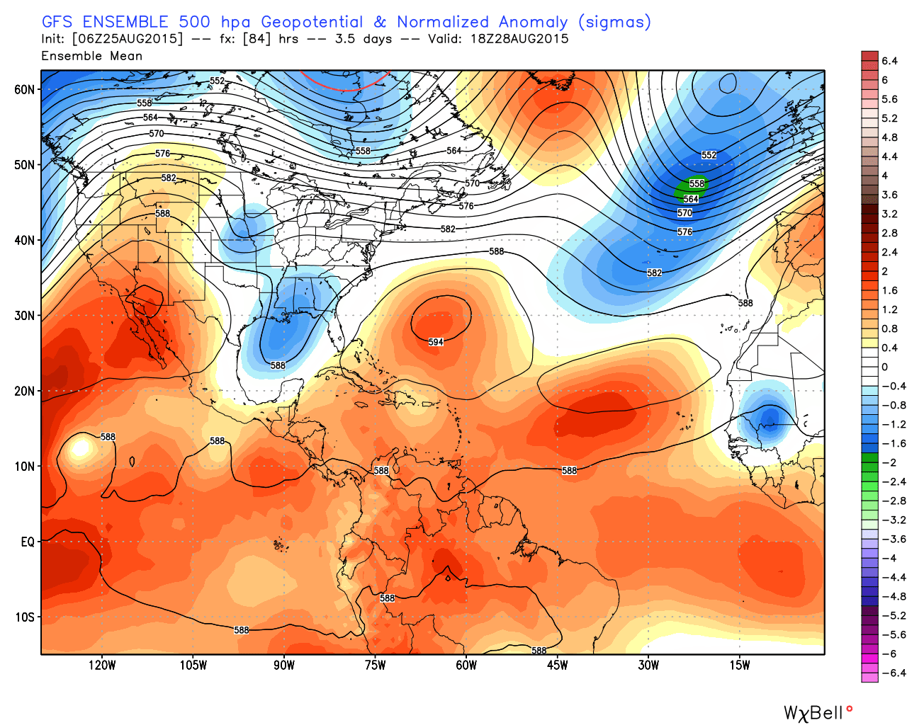
GFS model showing a strengthening Central/Southern Atlantic ridge keeping Erika on a west-northwest heading into this weekend.
Without any strong or widespread atmospheric shear, Erika could conceivably strengthen gradually during this time period as she moves at a fair speed to the northwest. Again, this will be a critical time period in the life-cycle of Erika. A path directly over the Tropical Atlantic Islands could totally change the game, weakening Erika dramatically.
Perhaps more notable than the ridge itself is the atmospheric pattern surrounding it over the next several days. Forecast models are in good agreement that the NAO (North Atlantic Oscillation) will continue its trek into negative territory, indicative of the presence of high latitude ridging (or blocking) over the North Atlantic and parts of Eastern Canada. Not surprisingly, many forecast models, including the ECMWF, show the development of a blocking ridge over New England, Eastern Canada and the North Atlantic Ocean.
This presents a few potential concerns for the track of Erika moving forward. Should the tropical system be a in a position somewhere in the Southwest Atlantic, near the US Southeast coast, Erika would have very little room to shift northeastward and likely would be forced either inland toward the coast, or slowly northward up along the coast.
If Erika is forced farther south by the Central Atlantic ridge, this could aid the system in westward movement toward Florida or surrounding areas. Not surprisingly, forecast models are inconsistent with both the strength of the Central US ridge and the timing of the development of blocking over the North Atlantic. This leads to a low confidence forecast moving forward.
Big signal; New calibrated ECMWF EPS giving a 50% chance for a landfalling tropical cyclone o/the East coast 9/1-9/3. pic.twitter.com/lZNOq8OfJW
— Michael Ventrice (@MJVentrice) August 25, 2015
One thing is certain: There is no need for hype or panic in this situation. The eventual evolution of the storm system is uncertain, as are the prospects for landfall on the US East Coast. While forecast models are currently hinting at a heightened chance of US Landfall compared to normal, there are still many potential solutions on the table — ranging from a track into the Eastern Gulf of Mexico to a weakening storm over the Southwest Atlantic Ocean.
Over the next few days, keep a close eye on Erika and stay tuned for the latest on the pattern evolution. We’ll be carefully monitoring forecast models and the latest data, with updates expected each day of this work week.