-2")
Labor Day ’98, New York City’s encounter with a derecho
September 7th, 1998 began with unusually warm and humid air throughout much of the Northeast United States. A southerly flow in the atmosphere had advected high dew points and unstable air farther north than normal — and much of the Northeast was experiencing late summer heat. The southerly winds were being aided by a developing trough to the northwest, over Southeastern Canada.
This trough and associated surface low pressure system would become the spark to ignite thunderstorms that would eventually race from Southeast Canada, through New York City, and off the coasts of New Jersey and Long Island. Impressive wind fields located throughout the Northeast US would support the development organized thunderstorms, capable of producing widespread damaging winds and a few tornadoes.
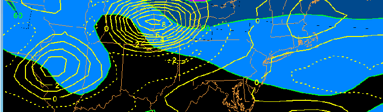
An overview of both derecho’s, with severe wind reports and a timeline. Courtesy, Storm Prediction Center/NOAA.
Labor Day 1998 was actually characterized by two separate derecho events. One, foreshadowing the event which would occur in New York City later that day, occurred from Midnight EDT through 6am EDT, in New England. Near midnight, a supercell thunderstorm developed in Niagara County, New York and began moving rapidly eastward. The complex reached Syracuse shortly after 1:00am EDT, killing three people and injuring ten. Wind gusts of 89 and 77 miles per hour were registered at Rochester and Syracuse airports, respectively. The National Weather Service estimated that winds exceeded 115 miles per hour in the most heavily damaged areas. Watch some awesome Weather Channel footage from the event here.
As the derecho continued eastward through New York State and eventually New England, tens of thousands of trees were knocked over. Over 1300 buildings were damaged overnight. Estimates still bring damages to around 130 million dollars from the overnight derecho alone.

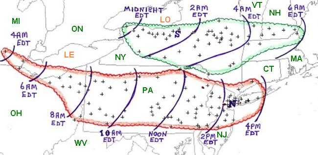
A loop of the Overnight/Morning Derecho on Labor Day (September 7th, 1998) as it moved through New York State.
While this derecho would dissipate and shift eastward off the coast of New England, thousands throughout Pennsylvania, New York, New Jersey, and Connecticut were in for problems of their own later in the day. The atmosphere was not stabilized by the overnight derecho in those areas, with its stabilizing effects remaining to the north over New England. Instead, a thermal boundary sunk southward — providing additional enhancement for thunderstorms which would move along it later that afternoon.
During the morning and early afternoon on September 7th, 1998, temperatures and dew points increased dramatically throughout the Mid Atlantic and Northeast States. The atmosphere was extremely unstable and primed for thunderstorm development. Meanwhile, over far Northeast Ohio earlier that morning, thunderstorms had developed on the leading edge of forcing from the trough over Southeast Canada.
The stage was now set for a derecho to race eastward through Pennsylvania: Highly unstable air, favorable mid and upper level atmospheric shear/wind fields, forcing to maintain the storms as they shifted eastward. The derecho rapidly developed and raced eastward through Pennsylvania, crossing the Delaware River near 1:00pm.

High resolution radar imagery (courtesy Rutgers) of the derecho as it sped through PA, NY, NJ and CT on the afternoon of September 7th, 1998.
The complex would then reach peak strength from Eastern Pennsylvania through New Jersey and Metropolitan New York. Four people were killed, 62 injured, with hundreds of thousands of trees toppled and at least 130 homes and businesses damaged. The severe thunderstorms continued producing damage along Long Island before exiting off the coast.
Meteorologically, both derecho’s were the result of a terrific juxtaposition of conditions. Highly unstable air overlapped unusually favorable shear. Enough forcing for storms to develop was present — but just enough capping in the atmosphere existed so that storm development wasn’t widespread. Instead, the cap would hold until prolific storm development could occur; and it did.
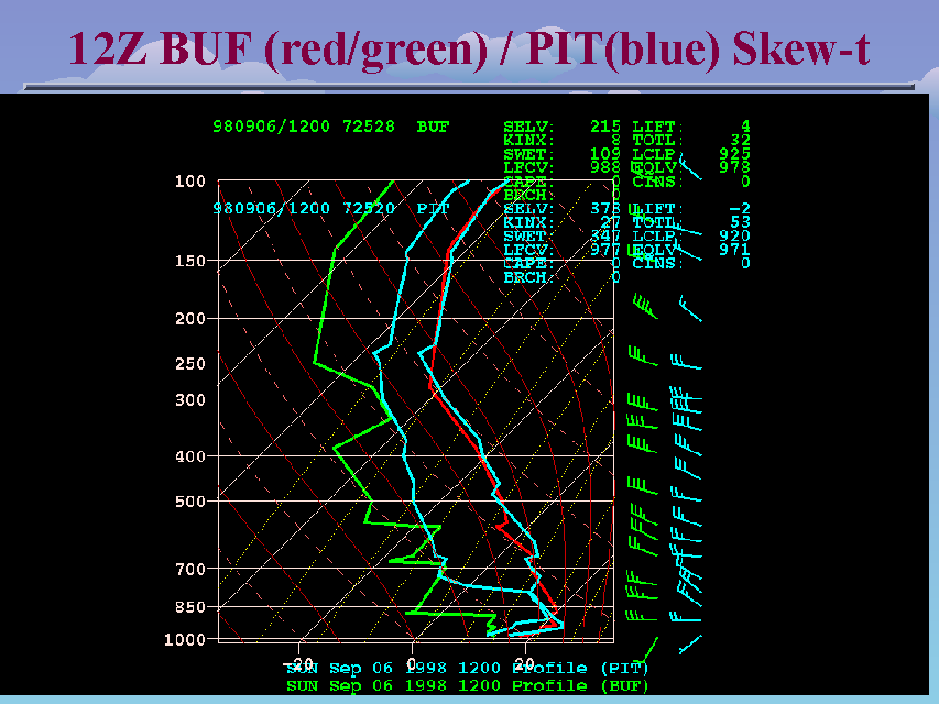
Soundings from Buffalo and Pittsburgh balloon launches showing an Elevated Mixed Layer and capping.
As prolific storm initiation occurred, the storms were perfectly placed on the periphery of a 100+kt 250mb jet streak. Low level moisture transport continued throughout the Northeast US. Very strong divergence occurred across the Great Lakes and shifted east. Upper level forcing, coupled with low level lift, allowed for synoptic scale ascent throughout the troposphere.
These featured moved rapidly east, effectively breaking the cap in place and allowing for all of the instability in place to be released. The result was two prolific derechos, both tracking eastward — one overnight, and one later in the following day — producing widespread damaging winds and realizing high amounts of atmospheric instability.

ETA model forecast (+12 hours) prior to the derecho event, showing an impressive 250mb jet streak as as well as divergence over Lake Michigan. (NWS)
For all intents and purposes, the Northeast US has not seen an event this prolific since this day in 1998. While the juxtaposition of such conditions can and has occurred, intricate details and nuances mitigate the development of such a widespread event, more often than not.
While we can’t rule out an event similar to this occurring one day, the Labor Day 1998 event will certainly live in the memories of residents and meteorologists alike, who experienced it and forecasted it 17 years ago today.
For more reading on this event we recommend the Storm Prediction Center’s overview, or the presentation from the National Weather Service.
Trackbacks & Pingbacks
… [Trackback]
[…] Read More: nymetroweather.com/2015/09/07/labor-day-98-new-york-citys-encounter-with-a-derecho/ […]
3marmalade
Comments are closed.