-2")
Drought buster: Heavy, tropical rains possible this week
A stretch of pleasant weather over the past several weeks will finally come to an end, as tropical moisture and multiple coastal storm systems bring an increased likelihood of rain.
The pleasant weather, while welcomed, has brought upon Moderate Drought conditions throughout much of New Jersey and New York, with the Department of Environmental Protection recently issuing a Drought Watch. The rains this week will put a significant dent in the deficits we have built up since late-summer.
Forecast models are in good agreement that a frontal zone will sink toward the area on Tuesday, with enough forcing and lift for precipitation to develop. Making matters even more interesting, a southeasterly flow will aid in the expansion of tropical moisture along much of the East Coast. As all of this occurs, models suggest a low pressure system will develop near the front, aiding in heavier and more widespread rainfall on Wednesday.

GFS model showing blocking and above normal heights (left) in the mid levels of the atmosphere this week.
One of the main players in the entire atmospheric set up is the development of ridging to our north, over the Northwestern Atlantic and Eastern Canada. This “blocking” ridge will help to slow down the mid level atmospheric flow over the Northeast, Mid Atlantic, and Ohio Valley. What would’ve otherwise been a passing trough and storm system will slow down and organize into a more formidable storm.
The formation of Tropical Depression 11, late last night, adds another wrinkle into the forecast dilemma later this week. After the development of a weak low pressure system along the frontal boundary on Tuesday and Wednesday, forecast models suggest the blocking ridge to our north could flex its muscles again: By forcing TD 11 north/westward toward New England.
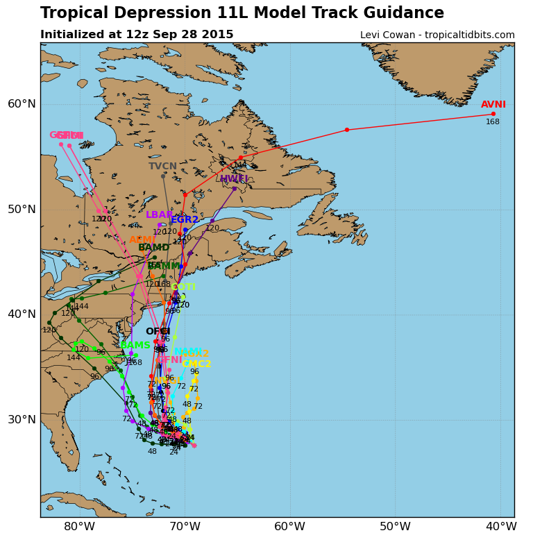
Forecast model tracks for Tropical Depression Eleven.
While the system itself won’t pose a “tropical storm” threat to our area, the moisture associated with it could bring heavier rains back into the picture once again on Friday and Saturday. As a the coastal storm system develops, and tropical moisture phases in, heavy rains could become widespread once again along the East Coast.
Forecast models currently suggest the potential for upwards of 2″ of rain in much of the area — but the current thinking is that local areas could see amounts that are quite a bit higher than that. The heaviest rains currently look to fall from Tuesday Night into Wednesday, and Friday into Saturday. As always, stay tuned for updates and the latest information on the heavy rains.