-2")
Prolonged onshore winds, tidal flooding on area shores
While the main story of the past several days has obviously been Hurricane Joaquin, the synoptic pattern results in several weather hazards regardless of the storms path. As mentioned a few days ago, the path of Joaquin was a concern, but hazardous weather was likely to occur whether the storm tracked toward our area or not.
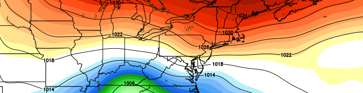
As a large high pressure system builds from our north toward Southeast Canada and New England, the lowering pressures to our south and east will aid in a continually tightening pressure gradient. At the surface, east/northeasterly winds will continue to surge toward the area coasts — specifically the New Jersey coast — resulting in increased wave heights. With rising tides and seas, coastal flooding is likely to occur through the weekend.
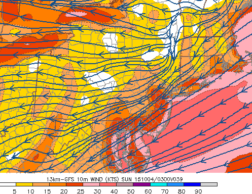
GFS model showing onshore winds continuing through the end of the weekend.
The National Weather Service has issued coastal flood warnings along many of the area shores through the next few days. The mention, as discussed above, the continuing easterly winds. Coastal flooding, additionally, has begun across much of New Jersey during this afternoons high tide cycle.
Onshore flow and high tide flooding events are not particularly uncommon along the New Jersey coast. But with high latitude blocking and a slow moving tropical system, this one has a particularly long duration — and will continue through the end of the weekend.
Some pictures of the New Jersey coast are attached below (via Twitter):
Street flooding in OC, NJ @fox29philly Winds are howling! pic.twitter.com/7MSB2SkF0a
— Bruce Gordon (@BGordonFox29) October 2, 2015
Surf is chewing away the sand in Ortley Beach. Walls are going up to prevent flooding in Ocean Ave. @News12NJ pic.twitter.com/2590qwb3YA
— Chris Keating (@Keating5) October 2, 2015