-2")
A few showers tonight, cooler weather will follow
High clouds are streaming into the area this afternoon ahead of a low pressure system, which is located well to the west-northwest of our area. The associated cold front, however, will sweep through the Northeast States later tonight into early Sunday. After a generally pleasant Saturday, a period of unsettled weather is likely from Saturday Night into early Sunday morning, with moisture pooling along the cold front and aiding in the development of showers throughout the area.
This front will eventually swing east of the area by later on Sunday morning. Behind it, another shot of cooler air will make its way through the Northeast states. Mid level temperatures will drop by several degrees, and northwest winds will begin in earnest. But this won’t occur fully until later on Sunday evening — and so despite the cooling occurring in the mid levels of the atmosphere, high temperatures will end up being quite pleasant. After the showers on Sunday morning, in fact, temperatures will reach into the mid 60’s with abundant sunshine.
The cooler weather will come by Sunday night into Monday morning, as mid level atmospheric temperatures drop further, and surface temperatures respond overnight. High temperatures on Monday afternoon may not make it much farther than the mid 50’s, with northerly winds, despite plenty of sun.
The next chance for widespread precipitation looks to come during the middle to latter part of the upcoming work week. The remnants of Hurricane Patricia will eventually move northeastward toward the Southern United States, and interact with a mid level atmospheric disturbance. This disturbance is expected to move northeastward — albeit slowly — and interact with another storm over Southern Canada.
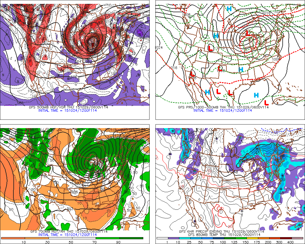
GFS model showing widespread rains throughout the Northeast late next week.
As this occurs, moisture from Patricia and the associated storm systems is forecast by many models to be pulled toward the Ohio Valley and Northeast states. The timing and strength of the storm system remain uncertain, and are likely to become more clear over the next few days. Nevertheless, it looks likely that a period of unsettled weather will occur later next week. And so, as they say, enjoy the nice weather while you have it!