-2")
Major storm likely this weekend, but uncertainties continue
Forecast models continue to slowly converge on the overall evolution of a large, powerful coastal storm which will evolve near the East Coast of the United States later this week. The agreement in regards to the storm development, on almost all global models and ensembles, is quite remarkable for this lead time. Almost every global model shows the storm system developing through the Mississippi River Valley, and eventually re-forming off the East Coast, moving northward to a position off the Delmarva. The exact track and intricacies of the atmospheric setup, however, create continued uncertainties in regards to the storms impact in our local area.
The setup actually begins to unfold later this evening, as a strong Pacific disturbance comes ashore in the Pacific Northwest. This disturbance is forecast, by all models, to drop southeastward through the Rockies, eventually to a position near the Central and Southern Plains states during the middle part of the week. During this time, another strong northern jet stream disturbance is forecast to race southeastward through the Dakotas, eventually phasing with the Pacific disturbance as it moves toward the Mississippi River.
What are some of the intricacies of the setup?
The actual evolution of the storm involves several moving parts, which set into motion the development of a very strong surface low pressure system off the East Coast. As mentioned, the Pacific disturbance is the first and most important piece of the puzzle to become established over the Lower 48 later this week. But out ahead of it, forecast models differ on the exact amount of troughing, or a confluent flow, which will exist over the Northeast United States. This quick moving trough is forecast to move through New England on Wednesday, and help to reinforce high pressure to our north.
While this helps re-establish a cold air source, it also suppresses the mid level atmospheric height field. In short, forecast models that have stronger confluence to our north are beginning to show the potential for a very tight cutoff in precipitation near our area — or, in some cases, the heaviest precipitation missing our area to the south. Monitoring exactly where this confluence sets up, and analyzing trends among operational and ensemble guidance over the next few days, will give us very important clues into how the storm will evolve.
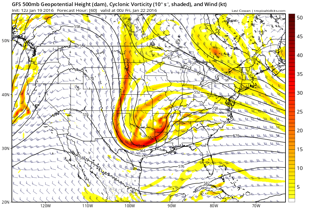
12z GFS showing a powerful storm system moving into the Central US, with a confluent shortwave over the Northeast US.
Regardless of this confluence, a strong northern stream disturbance associated with an impressive jet streak eventually phases into the Pacific disturbance near the Mississippi Valley and Southeast States. An initial surface low pressure system is forecast to move toward the Tennessee Valley, but a stronger low pressure will redevelop off the East Coast, somewhere near the Outer Banks of North Carolina.
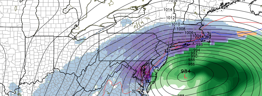
Most forecast models then take this low pressure northward, owing to very impressive atmospheric dynamics, and strengthen it near the Delmarva Peninsula. Very impressive upper level jet streaks and favorable orientation should help blossom precipitation northward toward our area later on Friday into Saturday. Thermal profiles support widespread snow throughout our area. It is at this time that the exact location of the surface low becomes critical — too far south/east, and our area will miss out on the heaviest snowfall. Farther north/west, and our area will be significantly impacted by the storm system.
These intricate details on all forecast models will have to be ironed out over the next few days — and thus, despite a strong signal for a storm system, confidence continues to be quite low in regards to the storms exact evolution.
What are some of the potential hazards the storm system would bring us?
There is no doubting it: This could be a highly impactful winter storm, if forecast models are correct in showing the northern track of the low pressure system. While it is too early to speak in regards to exact snowfall amounts, they could be quite prolific — with very heavy, wind driven snow for a prolonged period of time. Forecast models which show higher impact storms in our area generally begin the snow during the late afternoon and evening hours on Friday, and continue it through the evening on Saturday.
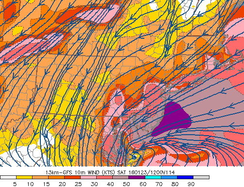
GFS model showing very strong winds along the New Jersey and New York coasts on Saturday.
In addition to snowfall, a major concern with this storm system is the potential for strong winds and coastal flooding. A low pressure tracking near the Delmarva coast would push a very tight pressure gradient into our area, enhanced by a high pressure system to our north. This would result in a strong easterly wind fetch, pushing into the coasts of New York and New Jersey. Wind gusts over 50 miles per hour would not be out of the question.
This weekends full moon and high tide cycle coinciding with the strong system could potentially signal moderate to severe coastal flooding, especially with the prolonged easterly wind fetch. Forecast models which track the low pressure farther south are, not surprisingly, less impactful in our area with snow, wind, and coastal flooding.
What should we do over the next day or so?
For now, hang tight. While the potential does exist for a major winter storm later this week into this weekend, there is still considerable uncertainty, as outlined above. With the important pieces of energy, and atmospheric disturbances, coming into closer view over the next day or so, meteorologists and forecasters will begin to get a much better idea as to how the storm will evolve.
We suggest this: Don’t may too much attention to individual snowfall forecasts at this juncture. We are still working to understand the atmospheric evolution as well as the track, intensity, and timing of the low pressure system itself. Stay tuned to your trusted weather sources for the most up to date information.
As a programming note, we will be publishing a free discussion video this afternoon, and are working on scheduling a live podcast tonight during the evening forecast models.