-2")
Premium: Midweek storm system hazards analysis
A significant storm system will develop this week, moving from the Southwestern United States into the Central Plains states by midweek. In the Northern Plains, blizzard conditions are expected to develop, with significant snowfall and high winds. Farther south and east, across the Arklatex, Mississippi River Valley, and northward to parts of the Ohio Valley, severe weather is anticipated as the storm system progresses northeastward.
In our area, much warmer than normal temperatures will advect northward as the system amplifies well to our west. In addition to the surface warmth will come moisture, fluxing northward in response to a strong low level jet. This will create the potential for heavy rain near and ahead of a frontal boundary, which will approach the area on Wednesday.
Storm system evolution and dynamics
With its origins in the Pacific, the storm system will amplify into the Southwestern United States before ejecting northeastward into the Plains on Tuesday. The storm system if forecast to be quite dynamic, with an impressive combination of blizzard conditions to the northwest (cold conveyor belt) and severe weather to the southeast (warm sector).
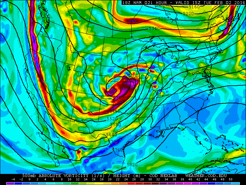
NAM model showing a strong, dynamic storm system over the Central US on Tuesday.
As the storm system approaches the area, forecast models indicate the presence of impressive mid and low level atmospheric dynamics. A strong low level jet (winds just above the surface) will move over the area ahead of the cold frontal boundary on Wednesday, with winds of 60 to 70 knots at 925mb (barely above the surface).
Additionally, a strong thermal gradient will exist with the cold frontal boundary, and increased forcing and lift will interact with unseasonable moisture to create the potential for heavy rain.
Potential hazards and preparedness
Heavy Rain: With the juxtaposition of a 60-70 knot low level jet, and higher than normal precipitable water values, will come the potential for heavy rain. The frontal boundary is expected to remain at least somewhat progressive, so prolific rain totals are not anticipated. However, the presence of at least weak instability could create heavier downpours and embedded thunderstorms. This could add to the heavy rain threat. Forecast models indicate the potential for said convection, and rainfall totals of up to 1″ throughout the area.
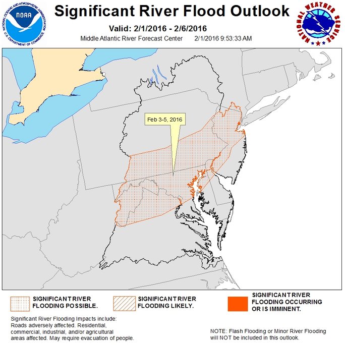
The NWS warns of river flooding potential during the middle part of the week, as heavy rain and runoff occur.
River Flooding, Runoff: With the heavy rain will come the concern for river flooding, runoff, and widespread urban/poor drainage flooding. A moderate snowpack still exists throughout much of the area, especially in New Jersey. River flooding will remain a concern with runoff and melting of snow as heavy rain falls. This could cause flooding near river banks, in low lying areas, and in flood prone zones. In addition, the heavy rain could cause deep ponding on roadways if snowpack is blocking drainage.
High Winds: Forecast models indicate a strong low level jet moving over the area as a cold front approaches the area on Wednesday Night. Heavy precipitation or convection could easily mix these winds down to the surface, but forecast soundings indicate the presence of an inversion which should stop the easy downward propagation of these winds. However, weaker inversion areas or stronger convection could lead to isolated strong wind gusts throughout the area.