-2")
Mesoscale boundaries will have impact on temperature forecast
Warm air will take over the area’s weather during the middle part of this week, as temperatures will soar into the middle and upper 70’s on Wednesday and Thursday. Much of this warmth can be attributed to a strong upper level trough over Mexico and now the South-Central Gulf States. This trough has pumped up a ridge over the Eastern US, allowing a deep southwesterly flow to take hold in much of the atmospheric column. This flow will allow for the aforementioned warm surge and support temperatures in the 70’s.
However, meandering to the Northeast will be an area of troughiness over New England and the Northwest Atlantic Ocean. High pressure will nudge into these areas during the latter half of this week, essentially flexing its muscles as the ridge over our heads weakens in amplitude just slightly. A notable (and quite impressive) thermal gradient will develop over New England, more affectionately known as a “backdoor cold front”, and will push southwestward a bit toward Southern New England.

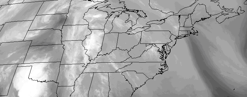
NAM model showing a noticeable backdoor cold frontal boundary over New England on Thursday, with warmth continuing in our area.
These backdoor cold fronts can actually enhance thermal gradients ahead and behind them — so we are expecting Thursday to be quite warm in our area, with the front off to our north and east. Its position will actually cause southwesterly winds to strengthen and become more westerly, reducing the onshore flow and keeping a warm, drier flow in our area in the low levels. Temperatures could reach the upper 70’s in some locations Thursday afternoon.
This cold front may eventually “Back” towards our area later in the week, but it seems more like a true cold front (which comes from the west) may approach our area first, on Friday. Forecast models have been inconsistent in depicting the backdoor cold front’s exact positioning as we approach the weekend, despite being adamant in its development.
Even so, mesoscale boundaries will have major impacts on temperature as early as Tuesday afternoon. While the flow that develops in the atmosphere is of southwesterly origin, there is more southerly component early on. This allows local and mesoscale boundaries to interact and cause differences in temperature. The colder ocean waters will have the biggest impact on Tuesday afternoon and evening.

HRRR model showing the progression of a seabreeze front inland from the ocean waters on Tuesday.
While forecast models show temperatures warming up into the lower and middle 60’s west of NYC, near the coast, the southerly flow aids in the development of a seabreeze. The cool ocean waters impact the temperature heavily along the shores, and eventually that seabreeze moves inland, causing cooler temperatures and possibly even some low clouds by the evening hours throughout the area.
Not to worry, however — it appears likely that the southwesterly flow will take over again by Wednesday morning, scouring out any low clouds or fog and leading to a stretch of very warm and pleasant weather from Wednesday into Thursday. Still, the mesoscale temperature boundaries will be on full display throughout our area this week, and will certainly be interesting to watch unfold.