-2")
(Premium) Long Range: Winter may take one final stand
While visions of 80 degree temperatures still dance in the heads of many after the warmth which surged into the area last week, old man winter many have been conjuring up one last surprise for us all.
It is, after all, still March. Calendar winter continues until the 20th of the month. With the atmospheric pattern undergoing major changes over the next few days, the record-breaking warmth will become a memory. Instead, colder high pressure to our north, the return of a ridge near the West Coast of the United States, and an incoming piece of atmospheric energy will become the main headlines. And yes, the teleconnections involved in the pattern could support wintry weather.
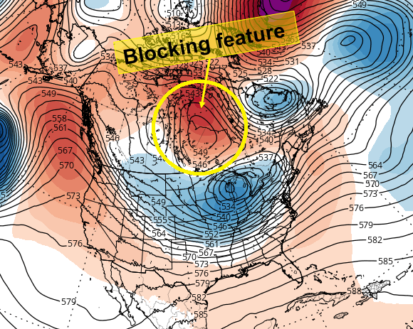
Forecast models show a blocking feature over Central Canada that helps to change the pattern by the middle to end of this week.
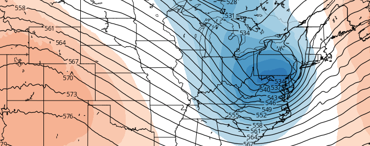
The pattern begins to change as early as Wednesday. A large trough and progressive pattern, which has been a steady feature on the West Coast of the United States, will be replaced by a large and high amplitude ridge. This ridge runs near the West Coast and northward into British Columbia. The troughing present over the West Coast, which last weekend even extended southward into Mexico, has helped to amplify a ridge on the East Coast of the United States early this month. This ridge has brought in southerly winds and warm air — with temperatures breaking records on several occasions.
But the changing pattern out west will have major implications in our area, and the West Coast isn’t the only place that changes are occurring. A large block will form over Central Canada this week, in tandem with the ridging on the West Coast of the United States. This will force a confluent flow into Southeast Canada, with cold air once again becoming established in that area. The block will eventually collapse southward, as energy from the Pacific enters the United States toward the latter half of the week.
Does this script sound familiar? It should. The pattern progression advertised on most models over the next 7 days is a fairly classic “precursor pattern” for an East Coast storm system of some kind. Adding intrigue to the setup, as if there wasn’t already enough, is lower heights in the Northwest Atlantic toward Eastern Canada. This type of pattern can often slow down the pattern to our north and anchor in cold air — allowing for wintry weather potential to be more easily realized.
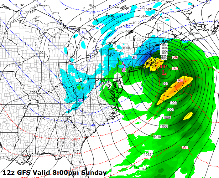
GFS model showing a major East Coast storm system on Sunday. Image courtesy Tropical Tidbits.
Forecast models, not surprisingly, are struggling with the details of the atmospheric pattern evolution. Individual features, their strength, and placement, will obviously have huge impacts on the forecast. Consider the strength and amplitude of the west coast ridge, and how it will impact the downstream pattern. Also consider the location and amplitude of the large block over Central Canada, and how that will affect all of the atmospheric pieces of energy around it. And then think about the actual disturbance itself, thousands of miles away, which will interact with all of the aforementioned features. It’s not surprising, when considering all of this, that uncertainty is low.
Still, to digress a bit, the potential for an East Coast storm system of some kind during this time period is certainly heightened. Monitoring atmospheric features over hte next few days will begin to give us a better idea as to exact how it will play out. And yes, of course, it will begin to give us a better idea as to whether or not the potential for wintry weather — which does exist in the advertised pattern — will be realized.