-2")
Here’s what we know about this weekends potential storm
Just when you thought old man winter had packed his bags and headed north for the year, he’s making a push to overstay his welcome once more. Forecast models have come into better agreement on the eventual evolution of the atmospheric pattern over the next several days, and there’s one thing that is certain: It will certainly be colder than it has been for the past week or two. Temperatures will settle near and below normal by this upcoming weekend.
Models also have hinted at pieces of energy which may enter the US from the Pacific, signaling the potential for a storm system along the East Coast this upcoming weekend. But the details, as they often do at this time frame, remain highly uncertain. Here’s what we know so far:
A blocking ridge will develop in Central Canada
Models are in good agreement that a blocking ridge of high pressure will develop over Central Cnada during the middle part of this week. This ridge will shift south from Central Canada toward the International Border, causing colder air to move southward into the Northern 1/3 of the United States. The ridge will also de-amplify over time, helping to provide a confluent flow over East and Southeast Canada.

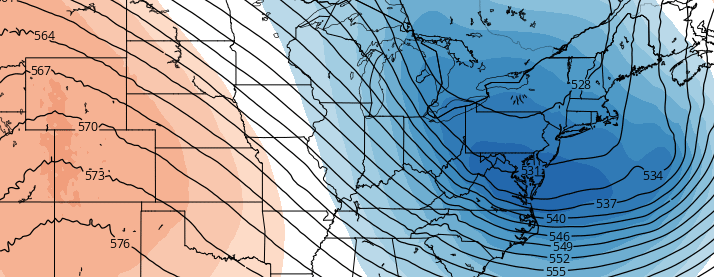
Overview of the atmospheric setup showing the west coast ridge, and storm developing near the East Coast. On this particular model run, the storm forms too far east and out to sea.
A ridge will develop on the West Coast
For the past few weeks, a large trough has dominated the Western US, allowing for ridging to move into the Eastern US and resulting in warm temperatures. This week, that trough will be replaced by a large ridge. This will help support the colder airmass over our region, and set the stage for energy to amplify as it enters the United States.
Energy may interact near the East Coast, forming a large storm system offshore
Forecast models, at various times and with varying intensity, have hinted at the potential for a storm system off the East Coast this weekend. Energy from the Pacfic and the Northern jet stream interact, driving southeastward and forming a surface low off the East Coast. With cold air in place to our north, some models have hinted at the potential for wintry weather.

This afternoons Canadian model showing a powerful storm forming just offshore.
Uncertainties continue
With all of that said, the uncertainties are quite large beyond that point. The atmospheric pattern evolution will depend highly on the placement of all of the aforementioned features. The west coast ridge, central Canadian blocking ridge, and incoming energy will all interact with each other, and the details on their exact track and location won’t come into focus for a few more days.
Monitoring their exact interaction, as well as trends among forecast and ensemble model guidance, will give us a better idea as to where this is headed by the time this week comes to a close.