-2")
(Premium) Increasing Potential for A Damaging Wind Event Saturday Night & Sunday
Over the past few days, we’ve been discussing on our new hazards dashboard the possibility for high winds for late Saturday night and Sunday. As we’ve gotten closer, model guidance continues to be consistent on this event. Therefore the National Weather Service has issued a High Wind Watch for the entire region late Saturday and Sunday morning. Details are still coming into focus, but confidence is growing that this could be a very strong if not damaging wind event for parts the area.
A vigorous mid-level shortwave will amplify and cause a surface low pressure coming east out the Great Lakes Saturday night to deepen rapidly over Southern New England Sunday morning. This will create extremely low mid-level heights and thus a frigid cold pool aloft — aiding in instability and dynamics, especially when combined with the off-the-charts vorticity being shown. An Arctic front accompanying this low will also move across the region late Saturday night with some rain showers, then perhaps a change to snow showers, during late Saturday night. Steep low-level and mid-level lapse rates and total totals in 50s show enough instability for snow squalls with gusty winds and possibly even thunder.
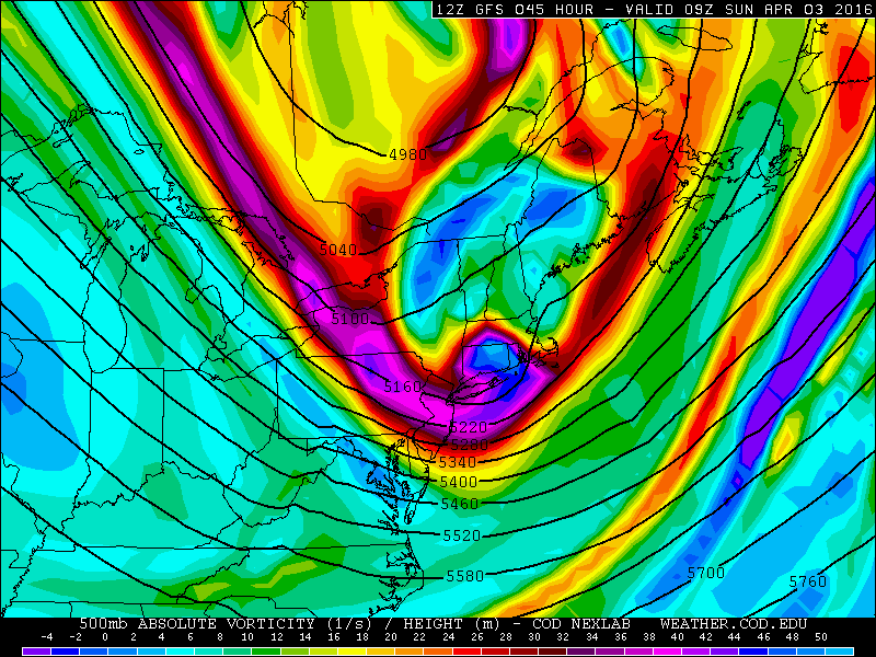
The GFS showing a powerful vigorous 500mb shortwave moving through region (NEXLAB).
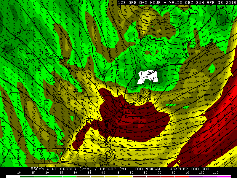
The Arctic front and shortwave lifts across the region late Saturday night. A very tight pressure gradient and deep mixing into a strong 850mb jet streak of 60kt-70kts over the region will cause strong winds to mix down in gusts out of the west to northwest late Saturday night and Sunday morning. At this time, the NAM and GFS model soundings on BUFKIT show the potential for wind gusts near or over 60mph — quite the anomalous situation considering we do not have a large, powerful surface low, and no day-time heating to add to instability. It is absolutely unprecedented to see such strongly, deeply mixed soundings with this strong of a low and mid-level jet, and with this much instability and turbulence without any daytime heating. Basically there will be strong sinking air behind a strong mid-level shortwave and a deepening surface low, which will cause stronger winds typically around 5000 feet to mix down to the surface, during a nocturnal period. It’s a very efficient deep channeling effect to draw down the strong winds aloft down to the surface.
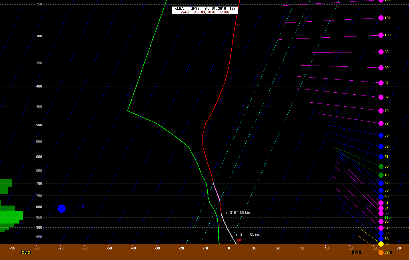
12z GFS for LaGuardia Airport at 5:00am Sunday morning showing winds at 65kt winds 850mb mixing down into gusts near 54kt (65mph)
Then this surface low and mid-level shortwave will track into the Canadian Maritimes on Sunday afternoon. The 850mb jet streak maxima will then shift east of the region. This might cause a brief lull in the winds sometime late in the morning. However, another strong jet streak at 700mb will be moving over the region during Sunday afternoon. More daytime heating and more subsidence in the mid-levels will help create an even deeper mixed layer that could tap into the winds just below this level later Sunday morning and afternoon. Thus, more gusts over 50mph possible later on Sunday. As winds blow, an Arctic airmass will be invading the region as well on Sunday. Temperatures will be falling into the 30s on Saturday night, and only hold in the upper 30s to at most low 40s on Sunday, and then fall back into the 30s and upper 20s on Sunday night. When combined with the strong winds, Wind Chills will be in the 20s for a sustained period of time from Saturday night through Sunday night, and may even bottom out in the teens during gusts at times early on Sunday morning when the winds will be the strongest. As winds subside on Sunday night, Wind Chills will rise back to around 30.
Overall, we expect that this high wind will be stronger than what we saw on Monday night. Make sure you take precautions with high winds likely on Saturday night and Sunday. Tie down any outdoor furniture or garbage cans, cut down any loose or weak branches, and do not operate construction equipment that could be adverse to strong winds. Winds will finally relax by Sunday night as the pressure weakens across the region.