Pattern change likely as February approaches with cold, stormy risks

A happy Tuesday morning to you all! We hope you are having a great start to your week. The weather across the United States has moderated quite a bit over the past several days, as you may have noticed, and from an energy standpoint this has led to a fairly substantial decrease in heating demand country-wide. This marked a fairly significant change from the early part of the winter and first half of the month. This warmth is expected to continue for the next 10 to 14 days, with ECMWF EPS and GEFS in good agreement. 

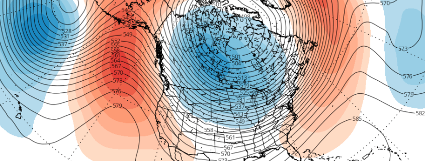
It is important to take a look at why this airmass is so much different than the one that brought deep, arctic cold to the United States just a few short weeks ago. When we take a look at the hemispheric weather pattern, there are a few significant pieces that are “driving” the weather pattern from a synoptic standpoint. First, we can look to the higher latitudes in Canada and the Arctic regions. 

Read more

The importance of the EPO and upcoming cold risks

For some time now, we have discussed the likelihood that colder than normal air would be a common theme in the Northern and Eastern United States during the month of December. Like most things, it was not expected to be constant, but it was expected to be prevalent, and especially when compared to the past few December’s which featured nearly coast-to-coast anomalous warmth in the United States.

After a warm start, colder than normal air invaded the Great Lakes, Ohio Valley and Northeast during December’s second week. Winter weather threats have followed, with many areas recording multiple snowfalls. While this airmass hasn’t broken records, it has been just as anomalous as advertised, and has had an obvious impact on markets and businesses. After a brief period of moderation, forecast models are beginning to signal the return of arctic air into the USA – and this time it may be more anomalous than before.

Read more

Wintry Mix for Interior Northeast Tuesday Before Arctic Blast Arrives, Late Week Storm Threat?

Good evening! Chilly and dry weather will continue for rest of the evening hours. But clouds will thicken and increase overnight, as the next storm system approaches. Mid-level warm advection ahead of warm front will start to cause Some light precipitation to break out well after midnight. Temperatures in the lower and mid-levels will be warmer, especially over New York City and coastal areas. So mainly rain is expected, although some snowflakes and ice pellets at the onset, can still occur. Otherwise, mainly some rain showers are expected through tomorrow morning, as temperatures rise into mid-upper 40s.

Over the Interior, especially higher elevations of Northwest New Jersey, the Hudson Valley and Northern CT more light snow, sleet and freezing rain is possible. This could leave coating to an 1″ or 2”, before perhaps change to rain during the midday hours. Temperatures will like rise only into the upper 30s to lower 40s in these areas during the afternoon. But should lead some snow and ice melting on on roadways and other paved surfaces. All precipitation will taper off during the early afternoon hours, as best dynamics begin to move northward into Northern New England.

Read more

First snowfall of the season for the Northeast this weekend

About two weeks ago, it became clear that the weather pattern was set to undergo a significant shift. After many weeks of warmth, a reshuffle was underway in the Pacific Ocean, and the downstream effects of this would lead to colder air with a more wintry pattern in the North-Central and Northeast United States. Two weeks and many forecasts later, here we are. The first snowfall of the winter is set to fall in the Northeast states this weekend, including the metropolitan areas of Philadelphia, New York City, Hartford and Boston.

Forecast models, for all of their benefits, were not keen to signal the potential for snow this weekend until about 24 hours ago. Forecasters had been monitoring this potential quite closely, but a snowfall of any significance always seemed like a long shot in the Northeast States. On Thursday morning, however, it became clear that a significant trend was underway, and forecast model guidance quickly began changing the evolution of the storm system during the weekend ahead.

Read more