-2")
First snowfall of the season for the Northeast this weekend
About two weeks ago, it became clear that the weather pattern was set to undergo a significant shift. After many weeks of warmth, a reshuffle was underway in the Pacific Ocean, and the downstream effects of this would lead to colder air with a more wintry pattern in the North-Central and Northeast United States. Two weeks and many forecasts later, here we are. The first snowfall of the winter is set to fall in the Northeast states this weekend, including the metropolitan areas of Philadelphia, New York City, Hartford and Boston.
Forecast models, for all of their benefits, were not keen to signal the potential for snow this weekend until about 24 hours ago. Forecasters had been monitoring this potential quite closely, but a snowfall of any significance always seemed like a long shot in the Northeast States. On Thursday morning, however, it became clear that a significant trend was underway, and forecast model guidance quickly began changing the evolution of the storm system during the weekend ahead.
Much of this change can be attributed to a very potent upper level jet streak which will surge into the Northeast states this weekend, in association with the storm system. In fact, this upper level jet streak is expected to be record breaking, with 250-300 hPA wind speeds nearing 200 knots across New England. The 200hPa wind speed climatology record for Albany, NY for example, is only 174 knots. This is important for many reasons, but none more important than the effect that upper level jet streaks have on precipitation. Divergence aloft can act to expand support for precipitation, even several hundred miles away from a low pressure center.
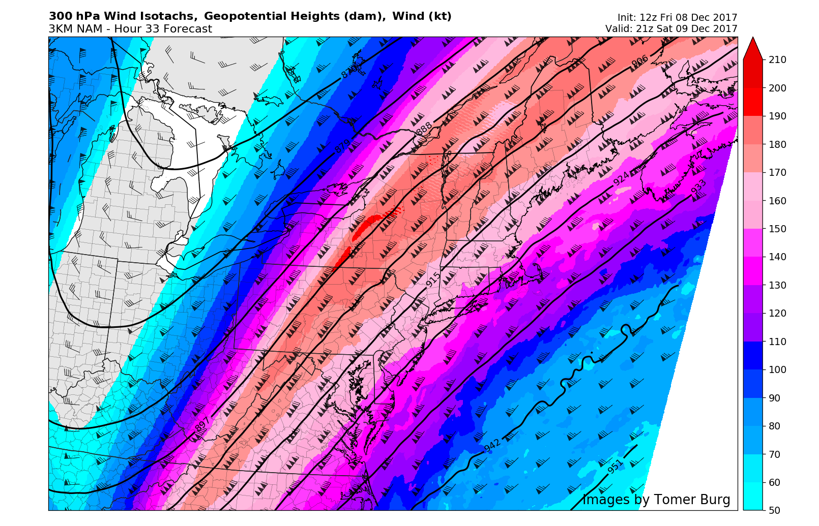
3km NAM showing parts of the Northeast in the right-entrance region of a strong upper-level streak at 300mb
Forecast models have played catch-up with the strength of this upper level jet in the last 48 hours and, as a result, have trended more impressively with the precipitation shield as a low pressure forms offshore. In addition to the upper level jet streak, models have trended more impressively with the mid-level shortwave trough over the Southeast States later tonight into Saturday. This trough acts to enhance positive vorticity advection up the coast and aid in the development of a strong low pressure system. Some modest mid-level frontogenesis will also lead to more moderate to briefly heavy banding, especially over eastern or coastal areas.
These two trends, when working together, have aided in the westward movement of the low pressure on forecast models and the expansion of precipitation. With models, ensemble, and mesoscale guidance now in good agreement, confidence is quite high in the forecast moving forward, with much of the Northeast coastal states expected to receive their first light to moderate accumulating snowfall of the winter season in the next 24 to 48 hours. Here’s how we expect the event to shake down:
Snow is expected to overspread the region during the early to middle morning hours on Saturday. At first snow will begin on the light side. Gradually, as the day goes on, the intensity of the snow is expected to increase. Snow will begin to fall moderate to perhaps heavy at times during Saturday afternoon and into the evening hours. It may mix with some sleet or rain at times, as warmer air intrudes in from off the ocean over the Twins Forks of Long Island. But all snow is expected elsewhere and to accumulate quickly on roadways. The snow will begin winding down from west to east during the late evening and overnight hours. Snow should taper off for most areas by early Sunday morning. The highest snow totals will be where we anticipate the heavy snow bands being most present.
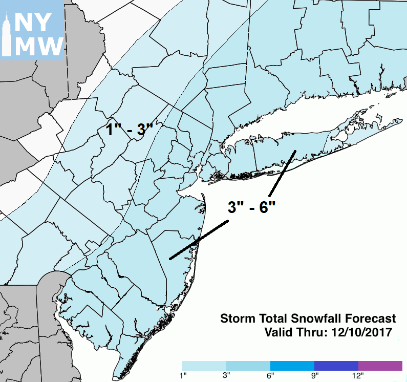
Snowfall Total Forecast for this weekend
For the rest of Sunday, a few scattered snow showers are possible, as some polar shortwave energy and a weak clipper low moves in behind Saturday’s storm. But these should not amount to any additional accumulations. Otherwise, more tranquil weather is expected with high temperatures in the upper 30s to lower 40s both Sunday and Monday. Then we will be watching for another storm developing over the Northeast, that could produce more wintry precipitation on Tuesday. More details on that storm will become clear as we move closer. Then an arctic blast comes will arrive behind Tuesday’s storm. High temperatures may not get out of the 20s or lower 30s for highs by Wednesday and Thursday of next week.
This cold and active pattern that we’ve anticipated will likely continue into the next few weeks, leading up to Christmas over the Northeast. Any warm-ups will likely be mitigated and brief, with some residual high-latitude blocking and ridging along the West Coast of North America supporting lower heights or more troughs over the Northeast. Stay tuned for more updates on this storm this weekend. More updates will be out for clients/members through tonight and tomorrow.
This article was written by John Homenuk & Miguel Pierre