-2")
(Premium) Will Warmer Weather Return Next Week?
After much warmer than normal temperatures during March, April has averaged cooler than normal so far, with some unseasonable cold weather for some days. This weather might seem bit ironic since we’re moving further into the Spring season. Some major league baseball games have to been postponed due to more unseasonably cold weather and even wintry precipitation in Northern parts of the nation. There are signs of a warming trend going into this weekend and early next week. But there are signs that this may be interrupted again due largely to high-latitude blocking.
Later this week, a large, deep cut-off low over the Rockies will cause a strong ridge to build over the Great Lakes and Ohio Valley regions. Another cut-off low will form on the downstream side of the ridge, off the East Coast. Initially, model guidance showed this cut-off low backing towards the region and affecting our weather this weekend. But high-latitude blocking weakening this week allows this low to remain farther offshore.
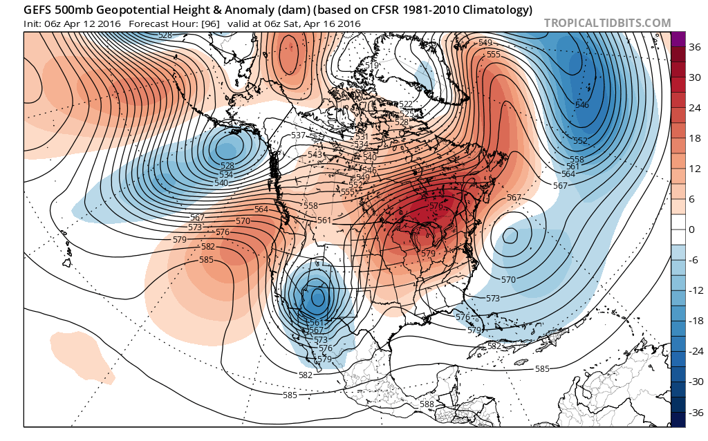
The GEFS showing a ridge over the Great Lakes and cut-off low offshore at the end of the week.
The cut-off low still will have a more indirect influence on our weather. This low will force surface high pressure to build more north and west of the region. Between both high pressure and low pressure will be a modest northeasterly flow that delivers a maritime airmass over the region on Saturday. Sunshine and dry weather is expected with plenty of ridging building aloft. But northeast winds will likely keep temperatures near or slightly below normal.
By late in the weekend, the ridge over the Great Lakes/Ohio Valley region will build eastward over the Northeast and Mid-Atlantic regions. The cut-off low will move further out into the Atlantic. This pattern will allow for surface high pressure to build further south and east of the region, thus resulting in return southwesterly flow for at least Sunday and Monday. Warmer than normal temperatures are likely for the region, perhaps reaching well into the 70s with plenty of sunshine still expected.
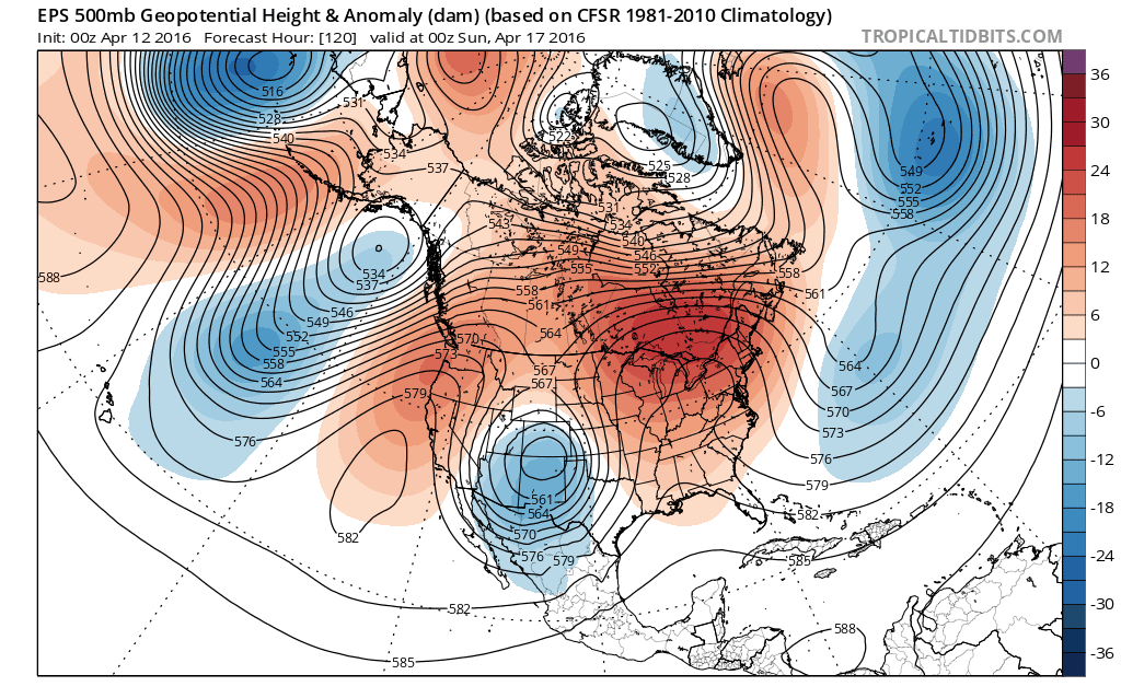
The Euro ensemble mean pattern evolution for next week: The ridge builds into the East for early in the week. Then high-latitude blocking returns over Greenland/Davis Strait and an upper-level low forms near Newfoundland. Ridge also develops over the West Coast, lower heights return again over the East again late next week.
However, some uncertainty lies thereafter on the duration of the warmth. Much of our model and ensemble guidance are suggesting some high-latitude blocking will return over Greenland or the Davis Strait with a deeper trough over Southeast Canada next week. This could result in strong confluence zone to the north, thus supporting a backdoor cold front to pass through the Northeast and Mid-Atlantic region during the middle or later part of next week.
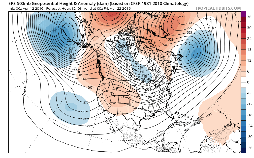
Long-range ensembles also indicate a split flow pattern out west, with a trough over Aleutian Islands supporting a ridge over Alaska/Western Canada, and active southern branch of the jet stream. This pattern could support more deeper troughs over Southeast Canada, enhancing more high-latitude blocking, into the following week. Overall, given the complete breakdown stratospheric polar vortex, and the +PDO and +ENSO influences remaining from the winter season, this Northern Hemisphere pattern appears to be supported.
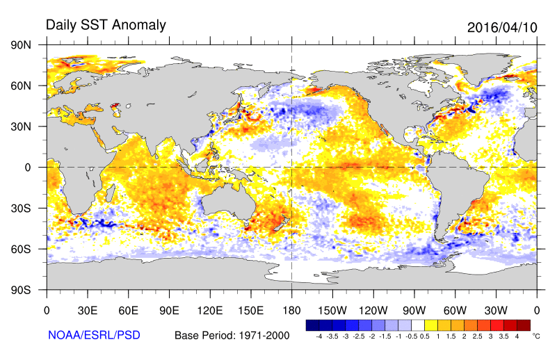
El Nino is weakening. But warmer than normal sea-surface temperatures are still present from over the Gulf of Alaska, along the West Coast and Tropical Pacific still indicate a significant +PDO and +ENSO influence over atmospheric pattern on the Pacific side.
All that being said, we use a lot of caution with longer-range guidance at this time. First, it’s possible that trough over Southeast Canada could result in a more zonal height field with west-northwest downslope flow, which would result in more warmer temperatures for the lower terrain. Second, the long-range and even medium-range guidance has often been of too aggressive or slow with atmospheric pattern changes. Thus more progressive trends have resulted with synoptic features. A current example is the cut-off low that was previously being shown to impact our region this weekend.
Also from a climatological perspective, it’s common to see more some cool weather with high-latitude blocking, cut-off lows, and especially backdoor cold fronts during the early spring season. So the pattern for April shouldn’t necessarily be seen as a large indicator of the pattern going into late spring or the early summer season. Just don’t put away the jackets and take out beach towels yet!
At this time, on our long-range outlook we are showing above normal temperatures with moderate confidence for weeks 2 and 3 for southwestern parts of region, while temperatures are closer to average over northeastern parts of region. However, this forecast is an average of anomalies on weekly period. This forecast may need to be adjusted as we get closer. The next long-range update is scheduled for Thursday.