-2")
Premium Weekly Outlook: Omega Block To Cause Unsettled Weather
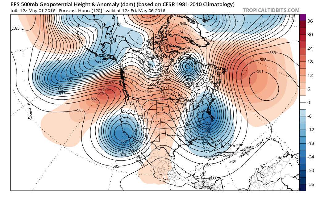
Model and ensemble guidance are showing an omega blocking developing this week over the North America. This blocking pattern causes shortwave energy to dig into trough or phase into a cut-off low on either of side of large ridge over the Central United States. This pattern can cause cooler, wetter weather to persist for several days over the western and eastern parts of the country. In this case, models are showing waves of low pressure developing along the East Coast this week. Model solutions differ depending on how they handle upstream shortwave energy coming digging into Southeast US.
First for tonight and Monday, periods of light rain and drizzle will continue tonight as warm front remains south of the region. Some areas of patch fog will also develop. Temperatures will remain steady in the middle to upper 40s. Another wave of low pressure and a shortwave trough will be moving north region tomorrow morning. The NAM models shows suggest more showers and thunderstorm rainfall with this wave. While the GFS and ECMWF models suggest more shower activity passes north the entire region. Some partial could take Monday afternoon as this wave moves away from region. This could help temperatures rise into middle to upper 60s. But if cloud cover remains, temperatures will struggle get out of the 50s.
Another shortwave coming out of the Ohio Valley, will cause an area of low pressure to develop along frontal boundary over the Mid-Atlantic region tomorrow evening. This is low track northeast late Monday night and Tuesday. Currently model guidance is not in agreement or consistent on how much rainfall will fall from this system over parts of the area. But the region is right-rear entrance region of a strong jets streak at 250mb-300mb. Which enhances divergence (lift) for more precipitation further north and deeper low pressure. Precipitable water values over 1.00″ would also support significant rainfall with enough dynamics in the region.
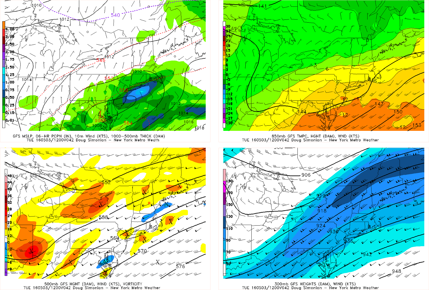
The GFS showing rainfall spreading well north of the surface low over Mid-Atlantic with with the region underneath the right-rear entrance region of a 300mb jetstreak.
Later in the week the models have indicated some phasing northern and southern stream energy into larger coastal storm, sometime around the Wednesday to Friday period. This would form into large cut-off low and then possibly a Nor’easter late in the week. Such a system would likely pull in alot of Atlantic moisture and could provide much needed rainfall. There is also chance some gusty winds near the coast. But this depends on the storm track and pressure gradients surrounding the this system. If the storm were to remain weaker, disorganized or further south we see would far less impacts. Previous runs of ECMWF model were much deeper and further west with low pressure along the coast for the next week. Instead it suggest another coastal storm may developing, underneath a cut-off low near the Mid-Atlantic region on Friday.
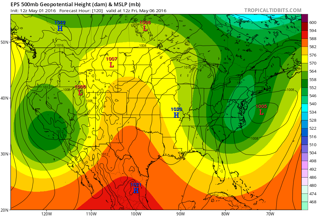
Euro ensemble mean show and omega block. With cut-off low over Southwest US , cut-off low along alone Mid-Atlantic coast and a strong ridge over Central United States. Surface low and coastal storm gets more organized off Delmarva coast on Friday.
The model solutions will likely to vary the the details of energy rotating around the cut-off low for the next several days. This give us forecaster low confidence in forecast details for this upcoming week. However, there is current good agreement amongst the guidance that the omega block breaks down by weekend. This causes a more progressive flow to return. The cut-off low weakens and shifts east further into Western Atlantic. Some unsettled weather could linger in the local region into next Saturday though. The pattern afterward also continues to be more active with more zonal heights. Another upper-level trough over frontal system swinging the Great Lakes and Northeast may give the region some showers by next Sunday.