-2")
Premium: Intricate phase will determine magnitude of coastal storm
The details of a phase between a mid level disturbance over the Ohio Valley, one with surprising vigor, and a second disturbance dropping southward from Southeast Canada into the Northeast, will have significant impacts on the eventual evolution of a coastal storm system this weekend. The atmospheric evolution in the mid and upper levels is actually quite complex, and reminiscent of some of the storm systems that impact our area in the winter season.
The pattern actually begins becoming amplified and energetic today (Friday), as a large trough in the Western United States amplifies. This will force a large ridge axis to build to its east, over the Central Plains states. This ridge drives northward, amplifying into Central Canada. This sets the stage for a large and amplifying trough over the Eastern United States this weekend.
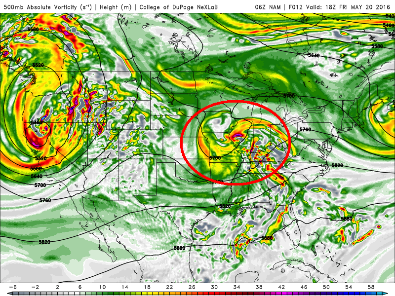
NAM model showing a vigorous shortwave over the Ohio Valley later today (Friday).
Meanwhile, a vigorous shortwave will be present over the Ohio Valley. Forecast models, not surprisingly, are struggling with the details of this feature including heat release, positive vorticity advection, and convection. All of these have major impacts on the exact evolution of the feature. Think of it this way; if this trough ends up slightly stronger, it amplifies the pattern to its east a bit more, allowing for more ridging ahead of the storm along the East Coast. A little weaker, and the shortwave itself can slip farther east a bit toward the coast.
This becomes critical when one considers the fact that a second shortwave from Southeast Canada will be surging southeastward. Remember the ridge we discussed earlier, building into Central Canada? That feature will force a shortwave to drop along its eastern periphery, falling into Southeast Canada, the Great Lakes, and eventually the Northeast United States. This disturbance will, eventually, phase with the initial disturbance over the Ohio Valley and Mid Atlantic states, forming a cutoff low. But exactly when, where, and how the phase occurs will have major impacts on our forecast.
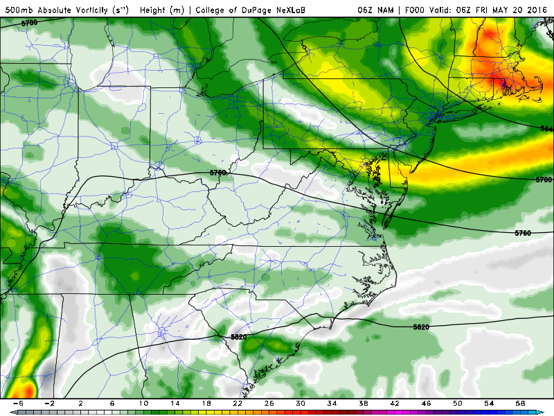
NAM model showing the evolution of the phasing disturbances over the East Coast this weekend.
An earlier phase of the two systems, as currently depicted on the NAM and some other short term guidance, will lead to the development of a stronger surface low pressure, which will be tucked in near the coast and acting upon more intense atmospheric dynamics. This will lead to a period of very heavy rain in our area on Saturday, with the potential for flooding in some areas. Coastal locations would likely experience heavy rain and strong winds — with coastal flooding impacts possible as well due to an onshore flow.
A later phase of the two disturbances, as currently depicted on some global models, would lead to much lesser impacts in our area. Much of this comes from the initial disturbance being allowed to slip eastward — as we discussed above — and the later phase would allow for the atmospheric dynamics to slip east of our area as well. While showers and rain would still be possible, our area would escape any heavy rain and/or strong wind impacts.
Ensemble guidance, currently, is not offering too much help. The GFS, ECMWF and Canadian ensemble means have trended toward a more impactful storm system, but still offer a large spread. Most notably, the SREF ensemble guidance shows a tremendous spread in possible solutions. While the mean precipitation amount in NYC is 1.35″, the spread still ranges from near 0″ of rainfall to near 3″ of rainfall.
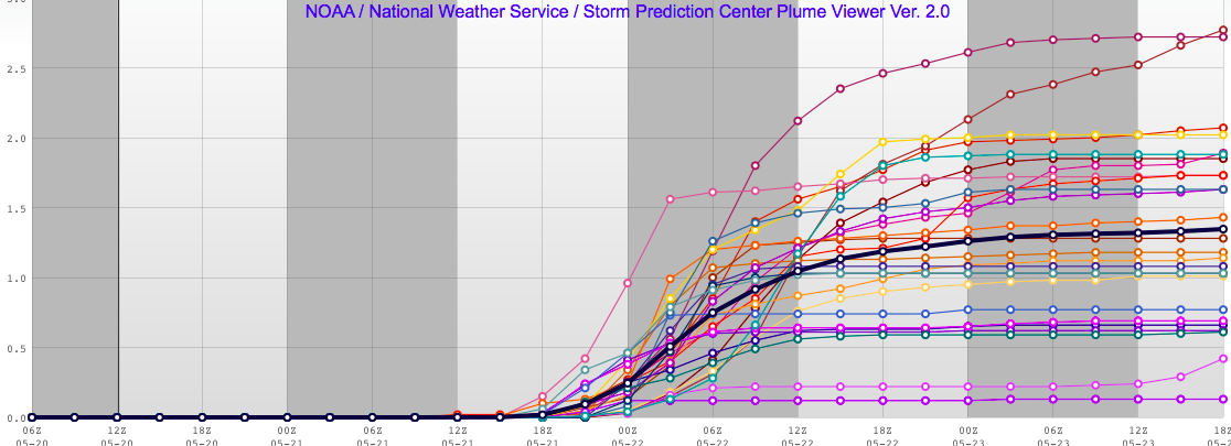
SREF Ensemble guidance continuing to show some uncertainty with the amount of rainfall this weekend.
Overall, meteorologically, confidence is building that the storm will impact our area. As mentioned above, forecast models may be struggling with the intricate details of the phase — and putting too much emphasis on things like convection and de-amplification of ridging out ahead of the storm. The overall pattern, while not a true or textbook Omega Blocking pattern, is almost a pseudo-omega blocking pattern. High latitude blocking in the arctic is slowing the pattern down enough to allow for this phase to occur.
With this in mind, the potential exists for periods of very heavy rainfall on Saturday as the storm moves toward the area. More likely than not, the heaviest rain will come in a band of extremely strong forcing and isentropic lift, which will push northward through the Mid Atlantic states as the system develops. On the periphery of a strengthening low level jet, very heavy precipitation is likely — and the rain may cause localized flash flooding. Strong winds are also possible during this time along the coastal areas with a strong onshore flow.
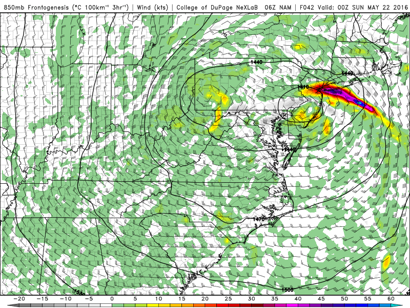
NAM model showing intense banding and frontogenic forcing in the mid levels of the atmosphere, leading to very heavy rainfall.
Forecast models continue to discern exactly where and when this band will push northward. The NAM, for example, shows the banding and strong dynamic forcing moving northward during the mid to late afternoon on Saturday, with driving rainfall moving through NJ and NYC between 4pm and 8pm. Thereafter, a mid level dry slot will approach the area, with a break in precipitation, followed by the return of showers for a period of time on Saturday evening into early Sunday morning.
The main takeaway is this: While the meteorological evolution and dynamics argue for the storm system to impact our area, the details of exactly how remain somewhat uncertain — including things like timing and intensity of banding and location of the heaviest rain.
We anticipate a live blog sometime during the weekend — most likely beginning on Saturday morning and continuing into Sunday morning as the storm system moves through our area. Stay tuned for the latest information and details including new data and model guidance.