-2")
Premium Weekly Outlook 6/06 – 6/12: Anomalous ULL dominates the week
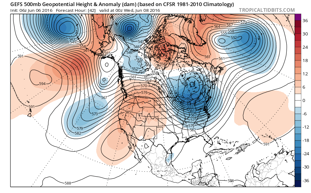
Much of this week will be dominated by a large anomalously cold upper-level low moving eastward into the Hudson Bay and Southeast Canada. After a dry day today, a couple of disturbance rotating underneath this upper-level low will be moving across the region on Tuesday and Wednesday. This could give us more clouds and chance for a few showers or thunderstorms each day. Then high pressure will settle in for more fair weather late in the week. But some troughiness will still linger over Southeast Canada and the Northeast through this weekend, with another shower and thunderstorm threat. A more technical discussion for this week is below.
For the rest of this afternoon, temperatures will remain in the lower the middle 80s for much of the region with west to southwest winds and plenty of sunshine. A sea-breeze could develop near the shore and bring temperatures down a few degrees. Mostly clear skies will continue into this evening, then some clouds will be increasing during the overnight hours. These clouds will be from a disturbance passing north of the region, and also streaming northward from Tropical Storm Colin, which will track into the Southeast US later tonight and then out to sea later on Tuesday. Temperatures will drop into the upper 60s to lower 70s.
A cold front and shortwave trough moving through the region will trigger some isolated or widely scattered showers and thunderstorms tomorrow afternoon and evening. The best dynamics with this system will likely be over New England. However, the NAM model forecasts an EML (elevated mixed layer) advection later in the afternoon. MLCAPE will increase to between 500 and 1000 J/kG and 0-6km bulk shear will also increase to 30kt to 40kts by tomorrow evening. If more forcing can coincide with this amount of instability and shear, there will be a threat for some isolated strong or severe thunderstorms tomorrow. The main threats will be for large hail and damaging wind gusts, as cold mid-level temperatures will lead to lower freezing levels for hail, and a denser airmass to more easily transport itself down to the surface for strong wind gusts.
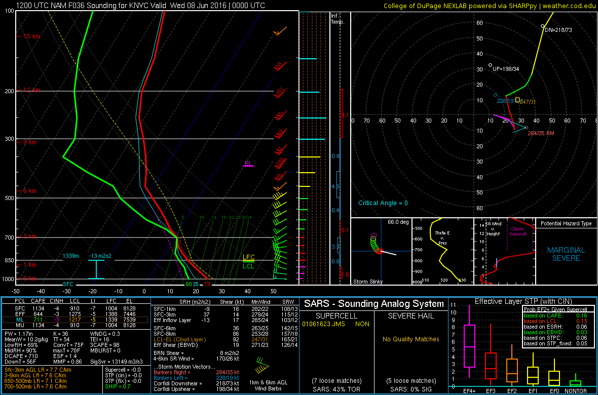
4km NAM sounding showing an EML with some MLCAPE, decent lapse rates and 0-6km bulk shear for isolated severe t-storms in the NYC metro by tomorrow evening.
This activity will diminish across the region later tomorrow evening. A cooler airmass will arrive behind the cold front. Temperatures tomorrow night will drop into upper 50s to lower 60s across much of the region. Some higher elevations of Northwest NJ and the Lower Hudson Valley could drop into the lower to middle 50s.
On Wednesday, it will be cooler as the upper-level low moves over more portions of the Northeast. Temperatures will be running several degrees below average with highs likely in the lower to middle 70s with westerly winds. The next upper-level disturbance is stronger and will be moving across the region with steep mid-level lapse rates and a cold-pool aloft. This could trigger more showers and thunderstorms with gusty winds, small hail or graupel. But chances are with lower CAPE due to low-level moisture and a weaker 500mb to 700mb flow thunderstorms will be less organized and under severe levels. But very cold mid-level temperatures could lead to freezing levels so low, that hail and graupel could still be possible even in relatively weak showers.
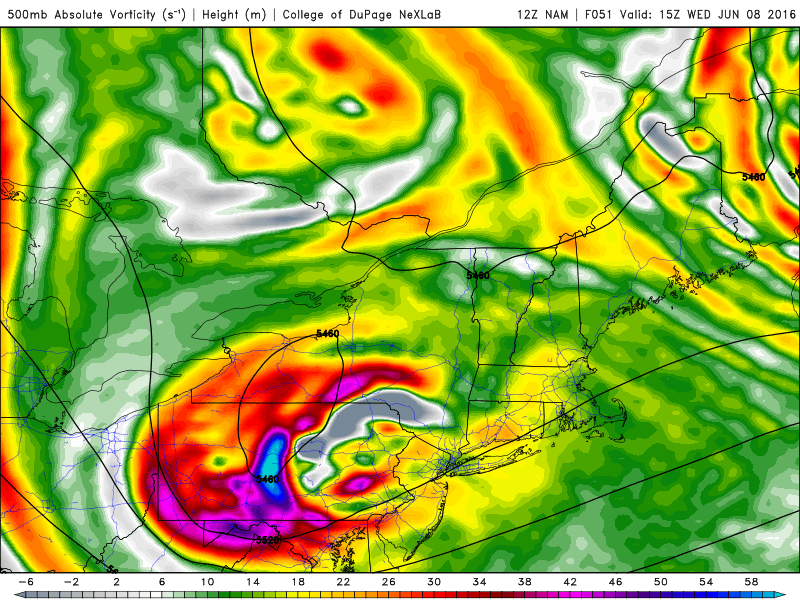
NAM showing a strong shortwave tracking through the Northeast on Wednesday (NEXLAB)
The ULL will then move into the Canadian Maritimes. High pressure will build in behind it for the rest of the week with more pleasant weather conditions. But the airmass will be of Canadian origin, which means temperatures will likely run slightly below average for each day between Thursday and Friday.
Over the weekend, a deep upper-level trough along the West Coast will cause a ridge to build into the Northern Plains and Central Canada. This will lead to lower heights downstream, with a large trough encompassing Southeast Canada and the Northeast US. The region will behind the trough axis, with a dry upper-level northwest flow.
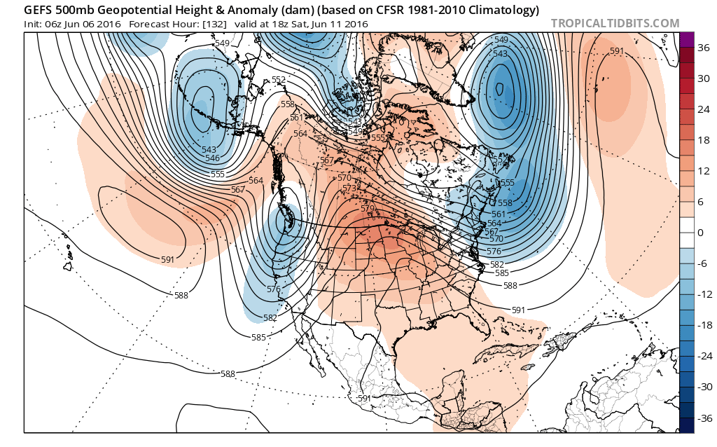
GEFS model showing a ridge over the Northern Plains, supporting lower than normal heights over the Northeast US this weekend (Tropical Tidbits)
However, model guidance shows an upper-level disturbance with an area of low pressure moving through the Northeast. This could cause showers or thunderstorms at some point during the weekend. At this time, it appears that the trough will be deep enough to keep the low pressure far enough south to keep us out of a warmer and more unstable airmass, which reduces the threat for more severe weather over the NYC metro region. But we will continue to monitor guidance for new trends throughout the week. If the trough lifts slightly northward, we could find ourselves in the northern periphery of the warm sector, and thus a strong to severe line of thunderstorms or a NW-SE moving MCS could not be ruled out. NW flow aloft supports enough wind shear to sustain a strong line of thunderstorms.
This article was written by Miguel Pierre and Doug Simonian