-2")
Premium: Late month pattern change likely to be gradual
As discussed in the winter forecast, the stratospheric polar vortex has been weakened since late October. A wave-breaking event, mainly induced by a large ridge in the Kara Sea, has resulted in 100mb heat fluxes remaining above average. We still believe the polar vortex is likely to be weaker and more disturbed going into this winter, especially compared to the past several years. However, some resistance from the polar vortex and tropical forcing influences will likely result in more gradual step down into pattern changes over next several weeks.
While westerly zonal winds have decreased to below average levels, a wind reversal or easterly winds aren’t being forecasted, particularly around 10mb and 60N. EPV at 10hpa also appears to shift from being poleward to more equatorward by the third week of November. Despite being severely disrupted; these winds allow for the polar vortex to remain quite large and profound over the high-latitudes. This will likely result in more neutral modality with the AO/NAO over next few weeks.
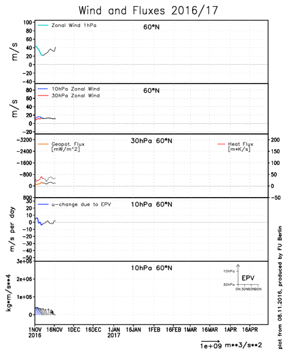
ECMWF model zonal winds at 10mb and 30mb and EPV at 10mb
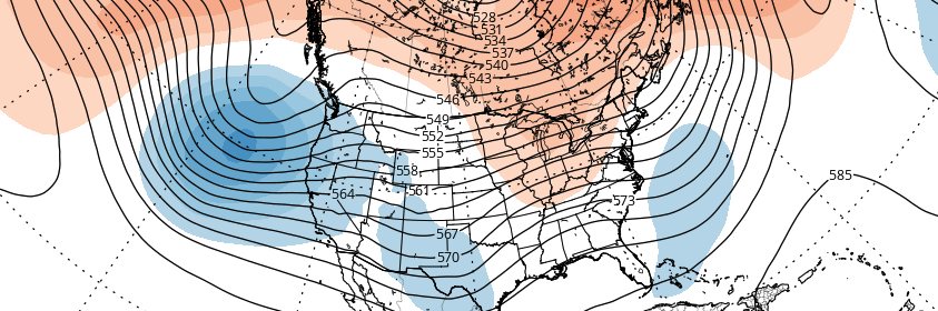
The polar vortex is forecast to be displaced from the north pole by the end of this month. This will cause a high in the stratosphere to form over the Aleutians. Along with tropical forcing in the Pacific, this will support repositioning of a deep trough largely over the Gulf of Alaska further back west over Northern Pacific. The resulting process will lead to more ridging over the Gulf of Alaska and over the West Coast of North America — with energy downstream causing deeper troughs to move into the Central US. This is shown next week on the European ensembles with development of deep low over the Eastern US.
However, the pattern will still be in somewhat of a transition with large scale features in flux, especially closer to the Atlantic side. Much of Canada will be warmer than normal over the next couple of weeks with Pacific air flooding eastward. This was the result of the polar vortex splitting at the end of October that displaced more artic air over Siberia. The airmasses that come down from Canada may still come with temperatures somewhat below normal, especially over Northern Plains and Great Lakes. But a true artic airmass invasion is not likely for the CONUS until the cold air source changes over North America as a whole.
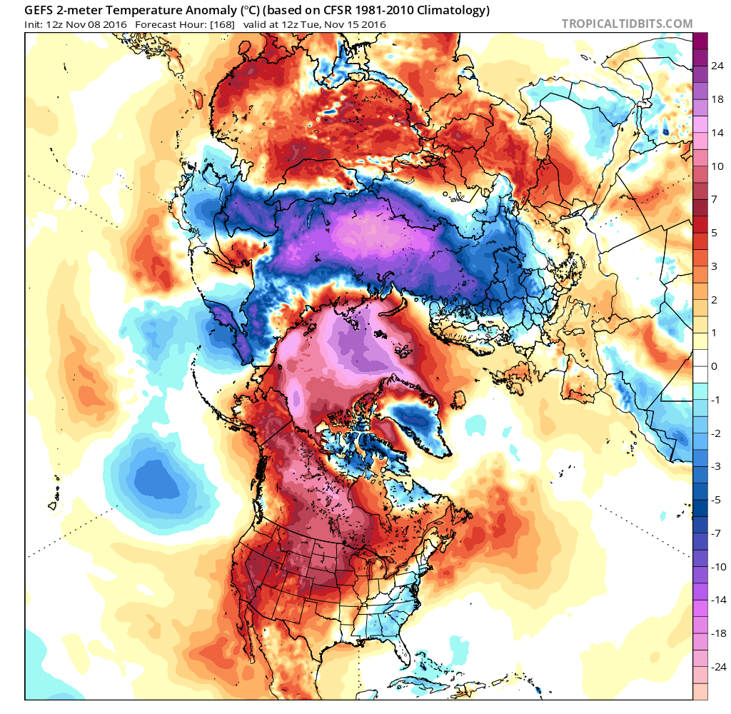
GEFS showing above average 2m temperatures over most of Canada and the Artic Circle in 7 days. More colder than normal temperatures over Eurasia
Without high-latitude blocking, these troughs will trend flatter and more progressive as they move eastward into the Eastern US. This will cause cold air masses that move over the Northern Plains and Great Leaks to modify by the time they reach the Northeast US and Mid-Atlantic regions. Cold air masses will be transient and move eastward rather quickly.
Currently ENSO conditions appear to be neutral with 30-day SOI values weakly negative. The MJO is typically more active during neutral ENSO periods and often coincides with stratospheric polar vortex weakening events. Most models have the MJO moving through phases 7, 8 and 1 over the next few weeks. A fast progression through Phase 7 during a neutral ENSO supports a deep trough over Northeast US this weekend as the model guidance currently shows. But this trough has already trended more progressive with just one day of below normal temperatures departures for the Northeast US. Phase 8 supports a stronger ridge to return with near to above normal temperatures over the Central and Eastern US next week.
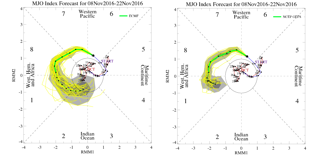
ECMWF and GFS ensembles MJO forecasts. ECMWF weakens the MJO in betweeen phases 1/2 later this month.. While GFS keeps it stronger in phase 8/1.
Phase 1 appears to support more troughiness over the East. But there is some uncertainty and model disagreement on how strong the MJO will be in the longer-term. The GEFS keeps the MJO much stronger into phase 1. If the MJO remains strong it will likely have more influence on the pattern going into December. If there is a weakening trend, the MJO will have likely have less influence on the atmospheric pattern.
Overall, we are still anticipating some large scale pattern changes supporting more cold weather to gradually occur over the next several weeks. However, the overall pattern will likely remain progressive with bouts of warmer and chiller weather for the second half of November, and perhaps into some part of December. Some more impactful precipitation events are possible. But a lack of high-latitude blocking will make it more difficult for any huge winter storms along the east coast, especially during the month of November. There will likely be volatility on model and ensemble guidance over next weeks as well.
We continue to watch trends with the stratosphere and MJO as we go along through the month. The long range outlook has been updated for Tuesday with a weekly breakdown of the pattern evolution over CONUS during the next 4 weeks. Stay tuned for more long-range updates by weeks end.