-2")
Wintry weather likely in the Northeast Sunday into Monday
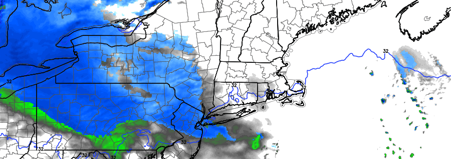
A much discussed storm system will finally make its trek east through the United States this weekend, arriving in the Ohio Valley and Northeast United States from Sunday into Monday. An initial disturbance pushes eastwards on Sunday, shearing out and weakening but still providing the impetus for some preliminary wintry weather. The more significant disturbance waits until Sunday Night and Monday to impact the Northeast US, bringing with it a significant amount of moisture and lift for precipitation. Snow is expected to shift northeastwards from the Ohio Valley gradually as Sunday evening goes on.
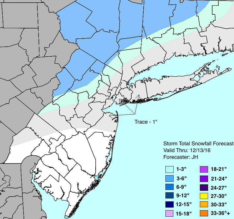
That’s where the complications begin: A surge of warm air associated with the system will be battling a departing high pressure, which will be on borrowed time as it moves away into the Atlantic Ocean. This spells the likelihood of mixed precipitation and transitioning precipitation types after a start as snow, especially near the coast where wintry precipitation amounts will be extremely limited. But inland, where cold air is expected to be more stout, a few inches of snow are possible before the changeover.
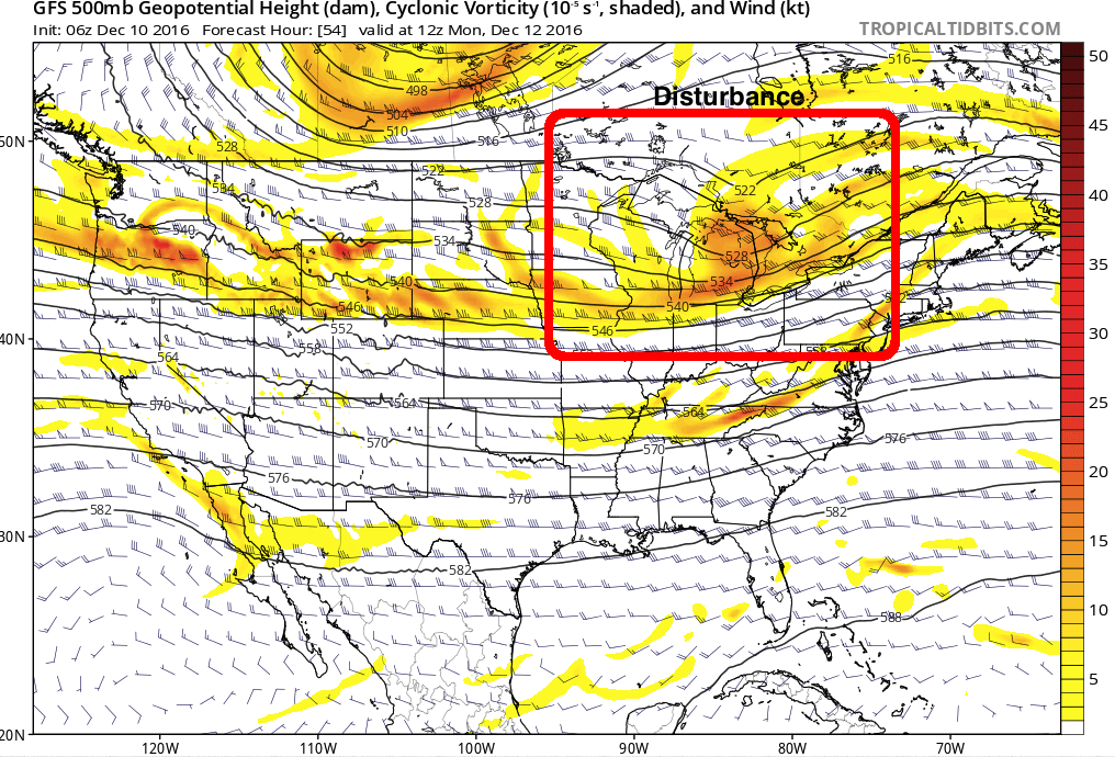
The disturbance impacting the Northeast US on Monday is easily recognizable in the mid levels of the atmosphere.
This will be especially true over New England where the high pressure is likely to remain in place for a longer period of time. This gives moisture more time to move into the airmass, allowing for a more prolonged period of snow. Further south (in the NYC, NJ area for instance) the cold air will be much more limited. This northward surge of warm air significantly complicates the forecast, while also putting a limit on the intensity of the event itself.
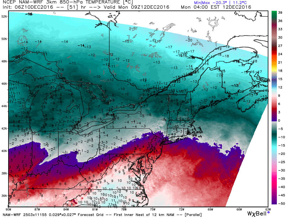
Much of what is occurring with this storm system stems from a process called “Warm Air Advection”. The center of the disturbance rides to the north of the Northeast US, meaning that south/southwesterly winds are the main driving force behind the lift that develops precipitation. Warm air advection occurs when warm air is moving in multiple levels of the atmosphere. In this case, it is helping precipitation to develop and moving into the Northeast US — and while aiding in lift it is also the culprit for the precipitation transition from snow to rain.
This advection process, as mentioned, occurs in multiple levels of the atmosphere. So the transition from rain to snow is often gradual, and occurs as the atmospheric column gradually warms to melt snowflakes as they fall on their way to the surface.
Warm air surges towards the area on Monday morning, resulting in precipitation changing to rain in New Jersey, New York, parts of Pennsylvania and Connecticut.
The greatest potential for snow appears likely to once again be in the higher elevations of Northeast PA and New York State — a developing trend this year — where upwards of 6″ of snow may fall before rain takes over. Otherwise, the progressive nature of the event and the propensity for warm air to surge northward will mitigate winter weather impacts. Nevertheless, the forecast remains somewhat uncertain at this juncture; the GFS and ECMWF models and ensembles remain at odds with temperature profiles — with the GFS remaining warmer and the ECMWF remaining cooler.
A slightly cooler or warmer solution on either side of the envelope could lead to significant changes in sensible weather over a relatively large area. Over the next 24 hours, it will be important to monitor a few things, including: The exact track and intensity of the disturbance, the presence of warm air advection and how strong it is, the location and strength of the high pressure over New England before the event starts, and the timing of the system itself.
While we are comfortable with our going forecast — it is important to communicate the uncertainty as well, so we recommend staying tuned over the next 24 hours for updates and information as we continue to work with new data and information going forward.