-2")
Forecast Soundings and Radiational Cooling
850mb temperatures are only around average or slightly below average. There is a large Southeast ridge with positive 500mb height anomalies. The previously large North Pacific block that generated our cold and snow last week has been replaced by negative height anomalies, cutting off the US from any cold airmass. So why is it so cold tonight? What it essentially comes down to is surface high pressure and radiational cooling.
On the heels of the piece of the Tropospheric Polar Vortex that got sent towards the US from the aforementioned North Pacific block was a very large surface high pressure system with Arctic origins. While the Polar Vortex quickly retreated back into the Arctic and the US was being replaced by a much warmer airmass aloft, this surface high pressure system was massive enough and had enough initially very cold source regions to deposit incredibly cold air into the US. The coldest temperatures were to our west in the Central Plains, where places in Texas dropped from the low 80s to the upper 30s within one hour! This cold air got modified somewhat as it headed east, but it still packed quite a cold punch on Monday, as temperatures in NYC did not get out of the 20s during the afternoon.
Looking at the weather on a more local level, we can see that there was strung out vorticity in the area that led to some high clouds earlier on Monday, but that will have departed the region during the overnight. You can see that it’s basically left the area by 4:00am. Since it’s the advection of vorticity more so than the vorticity itself that leads to clouds, and the vorticity will have been leaving the region, this means that clouds broke much earlier than that — around midnight for most of us. In Orange County, clouds already cleared at 10:00pm on Monday, and temperatures then quickly plummeted to the low teens.
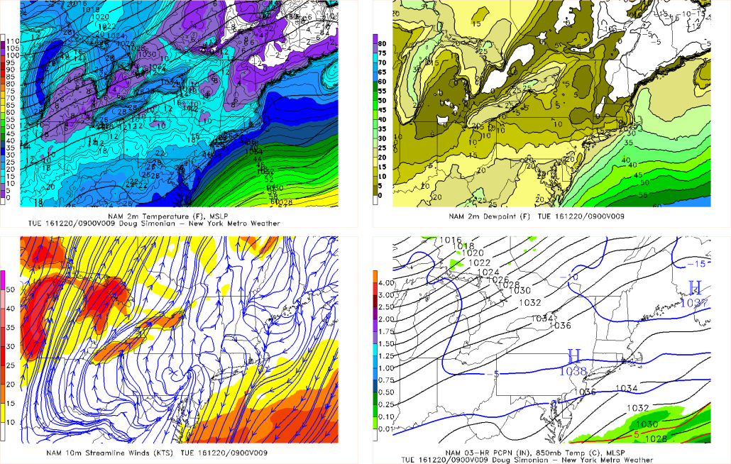
The 00z NAM run from 12/20 shows 500mb vorticity leaving the area. It also shows 850mb temperatures only modestly chilly.
What’s also to note is that jet streak on the bottom right also leaving the area, leading to less upper-level divergence and thus fewer clouds. 850mb temperatures are only around -3C, which really doesn’t support much in the way of cold, and neither do 500mb heights of 564dam. But look at the top left — the aforementioned large surface high pressure sitting over the region. This has led to a lot cold air to be trapped at the surface. Also notice the lack of a pressure gradient — there is a tight gradient well to our northwest, and again to our southeast, but over our area there is no gradient. Thus, winds are very light — a further indicator of radiational cooling in an already cold surface.

The 12/20 00z NAM run valid for 4:00am shows a classic surface high pressure sitting over the area, leading to very low dewpoints and radiational cooling.
Here is a look purely at the surface. On the top left, we can see that temperatures have easily fallen into the teens for much of the area, though closer to the city with the urban heat island effect, it’s around 20 or in the low 20s. The winds are all generally very light and variable as evidenced by the streamlines, and the surface high pressure is leading to very low dewpoints across the while Northeast. Now, something that is interesting is that while the dewpoints are low, they are generally in the high single digits to low teens, which means that once temperatures fall, the atmosphere will start condensing once they hit the mid teens. This leads to air parcels cooling moist adiabatically rather than dry adiabatically, which slows down the rate of cooling as moisture and latent heat gets released into the atmosphere. This is why widespread single digits are not likely, though our coldest suburbs will probably still reach the single digits.
Now let’s take a look at some forecast soundings. These are valid for 7:00am on Tuesday morning, when temperatures will be at their coldest.
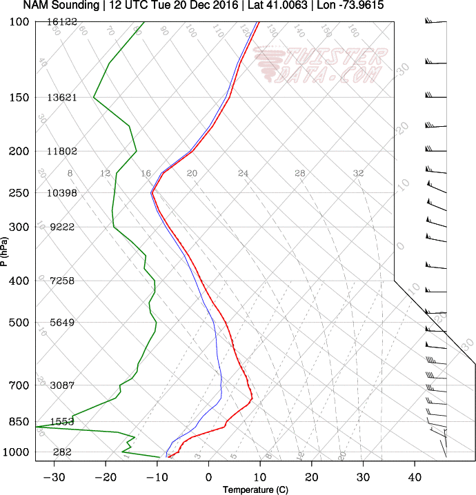
This point-and-click sounding from NE NJ shows an ideal radiational and subsidence inversion for cooling. High pressure is also evident here. (twisterdata.com)
There are several things to notice about this sounding. For one thing, it is an extremely dry sounding, particularly above the immediate surface and throughout the rest of the column. This is important because dry air is quite dense, and dense air has the tendency to sink. This is important for keeping cold air trapped at the immediate surface. Additionally, with the surface high pressure sitting overhead, that is also a byproduct of dry, sinking air, which prevents mixing with the warmer temperatures aloft. Thus, the heat at the ground can efficiently escape the ground as outgoing longwave radiation, and there is nothing to make any of that warmer air that’s escaping from re-interacting with the surface air. Also note the stout inversion from the surface through around 800mb. This is a classic subsidence inversion, which further puts a lid on any eddies or turbulence that would mix the ground temperatures with the warmer air above. This is also something that develops with high pressure overhead.
Now let’s look at the immediate surface. This is from NE NJ, so it’s a relatively rural area, where radiational cooling can occur more effectively than urban areas, due to surfaces with less albedo. This can further enhance the inversion by creating a secondary radiation inversion. This is clearly evident from the ground through about 1000mb, as the inversion is even more stout. This is an indicator that the radiational cooling has been significant, as it was enough to actually show the warmer air that escaped from the ground led to an even stronger inversion.
One thing that’s negative for cooling is the immediate surface dewpoints. Note how it’s relatively moist there — this is because there was enough radiational cooling to cool the surface temperatures towards the dewpoints, leading to potentially some condensation. Condemnation slows the rate of cooling as described in the beginning of this article. Also if you moisten the surface, it has a bit more of a tendency to rise, which could create some very minor mixing as well. This will ultimately keep low temperatures around or just above 10 degrees for most NYC suburbs, and a few degrees warmer at the coast due to more oceanic moisture adding to the aforementioned condensation. However, a few of the coldest locations could fall back into the single digits — more likely in more rural locations.
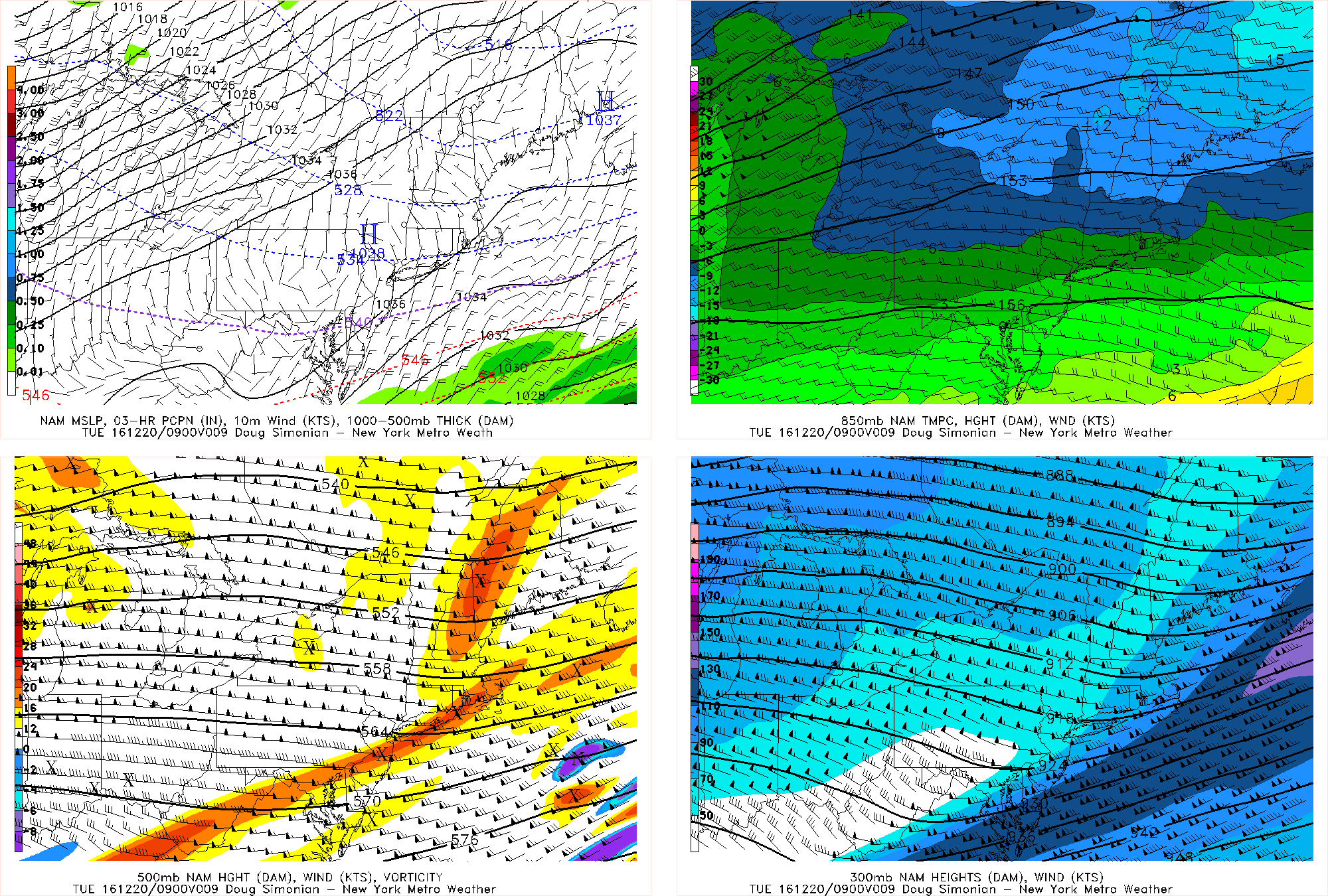
This subsidence inversion also may serve to keep high temperatures in the low to mid 30s on Tuesday, rather than the upper 30s to around 40. The NAM 2-meter temperature products (not MOS) shows highs in the upper 20s to around 30, which seems a bit extreme with the inversion, but it does go to show how influential these inversions can be on our surface temperatures.