-2")
1/13 All Zones AM Update: Colder This Weekend With Saturday Storm Farther South
An artic airmass over Southeast Canada that will begin filtering into all the zones gradually through this evening Temperatures have started falling into 40s over many of the zones this morning. Temperatures likely remain steady through in mainly in the 40s, through the midday hours. then slowly fall into 30s later this afternoon, from north to south across all the zones.
Later tonight, clouds will begin increasing from the southwest, as mid-level disturbance moves east from the Lower Ohio Valley. Temperatures will continue to fall down into lower to middle 20s over Interior zones to upper 20s to lower 30s over the coastal plain.
Latest model guidance continues indicate a weak wave of low pressure will pass well south of the region tomorrow. This is due to strong confluence between upper-level low traversing through over Southeast Canada and the Southeast ridge (as discussed more in prior premium article). However, aforementioned mid-level disturbance and jet streak running by will likely result band of light to moderate band of precipitation along the modest 850mb thermal gradient.
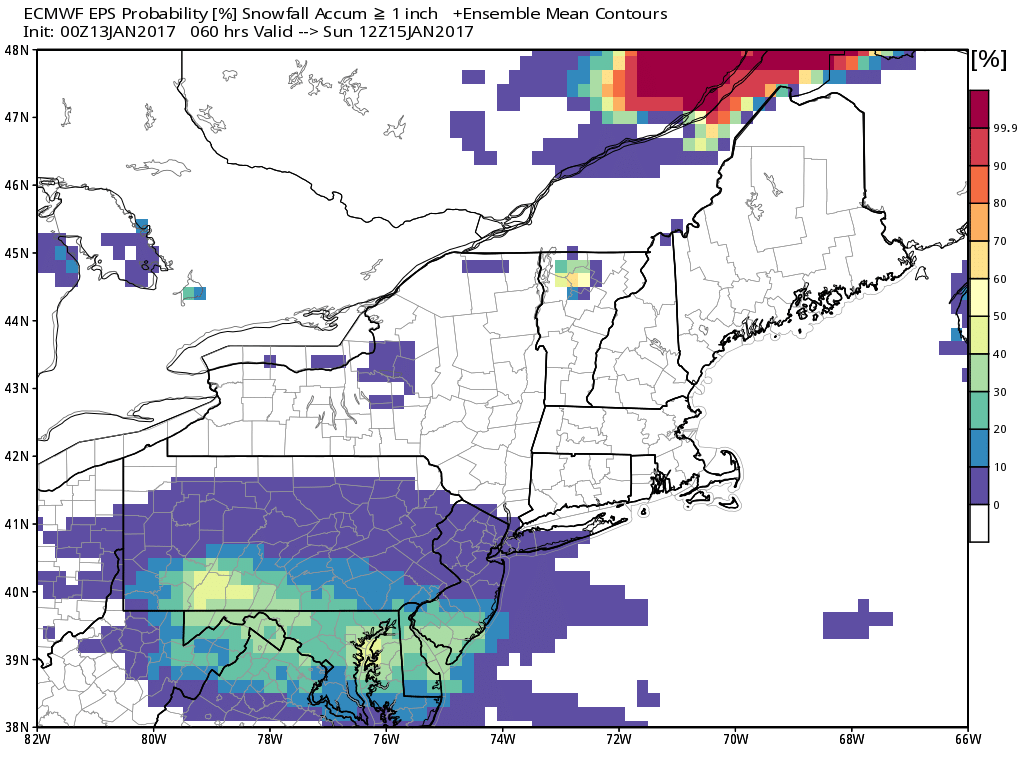
0z Euro ensemble mean showing 20-50% probability of 1″> snow tomorrow near the Mason Dixon Line
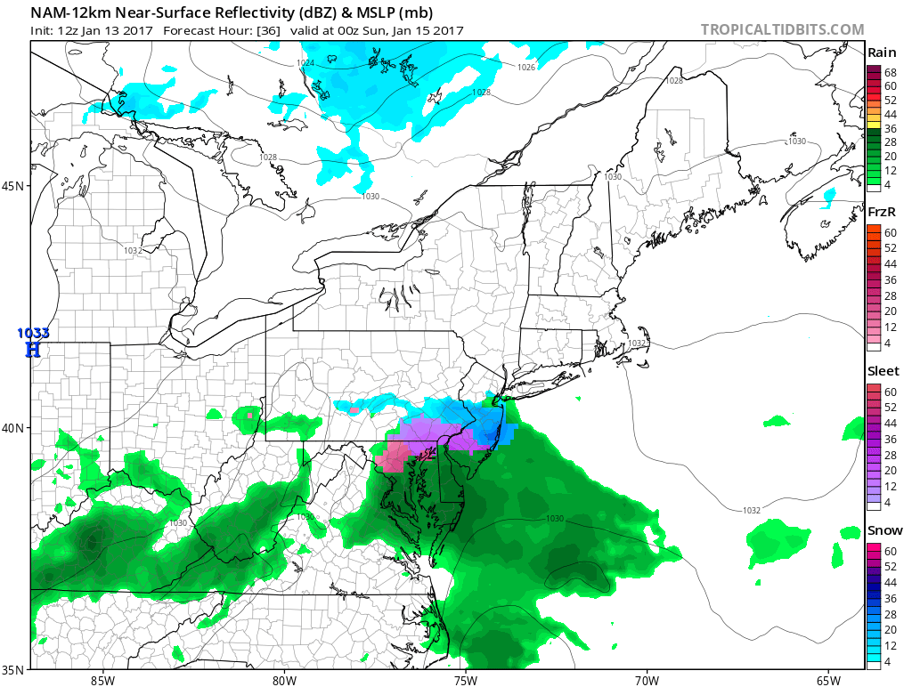
Overnight a blend of the NAM, RGEM and ECMWF guidance, indicated this band would be over Southeast PA, Southern NJ zones, with possibly 1”-2” of snow parts over these areas, But the latest 6z GFS model has this band further south over MD/DE region. Some of early 12z runs of NAM and RGEM have also shifted further, with just more snow showers over the region. There is also still possibility that enough warm air, may move into in mid-level for some sleet or rain to mixing over extreme southern parts of these areas. But this chance will lower as well if south trends continue. Surface temperature may also rise above freezing for these are with daytime heating and a light onshore flow. So forecast confidence is not high with much snowfall even for the southern zones.
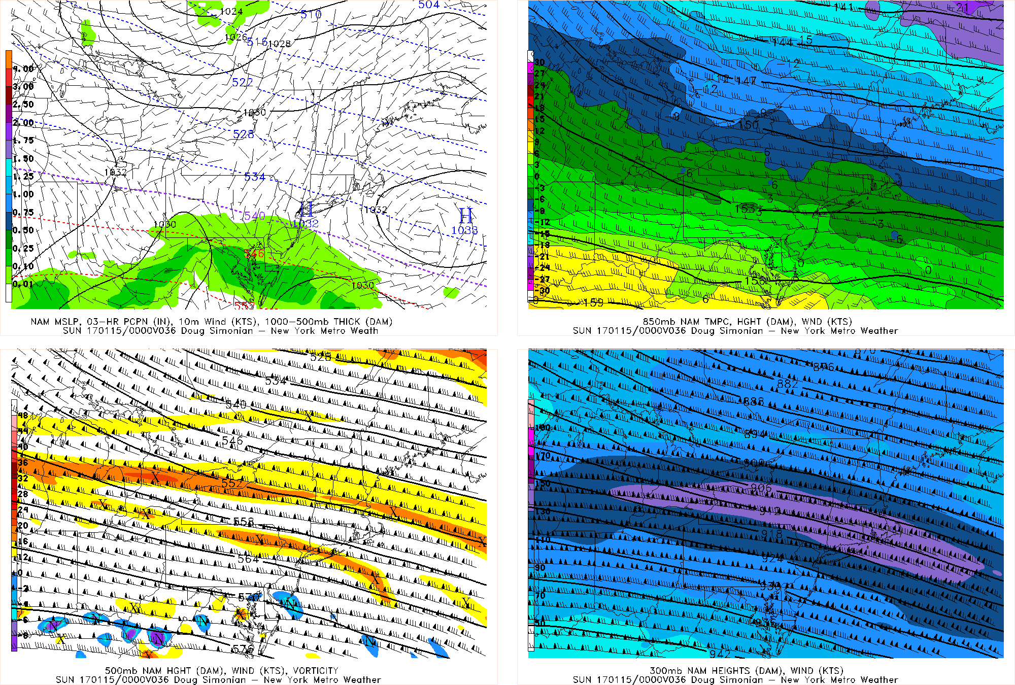
The 12z/13 NAM showing strong upper-level northwest flow and confluence with high pressure, keeping this system farther south of NYC metro Saturday
Further north up to North-Central NJ, New York City and Long Island some lighter snow showers are possibility by tomorrow afternoon or evening.. However, any accumulation is expect to be under 1″ and roads may stay mostly wet, with temperatures near or just above freezing, especially over more urban areas. It’s possible much of day winds up dry. Very little or nothing is expected to fall over Extreme Northern New Jersey, the Lower Hudson Valley and Connecticut zones, with more subsidence from high pressure. Overall, this system will be just a nuisance over the region, especially for any travel south of NYC.
The arctic airmass with high pressure to the north, will sink further south into the region tomorrow night. Any lingering precipitation will taper off during the evening hours. Then skies being clearing late at night.. Thus temperatures will drop into the 20s again over most of the region. Sunday is looking mostly sunny and seasonably cold day for the region with highs in the upper 30s to around 40.
Stay for more zone forecast updates this afternoon or evening for this weekend.