-2")
Public Analysis: Strong Nor’Easter brings a myriad of impacts today
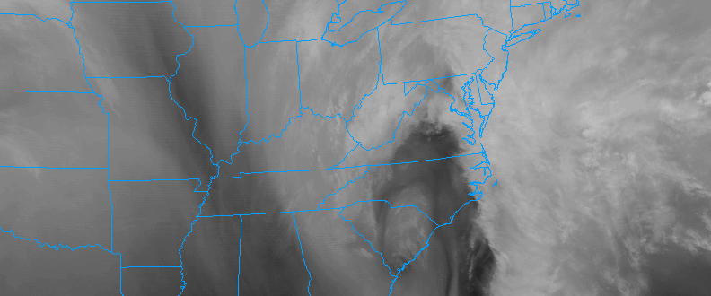
A well discussed and documented Nor’Easter will develop later today from the Mid Atlantic states to the Delmarva coast, bringing heavy precipitation and a myriad of hazardous weather to the area which will continue through Tuesday. The low pressure area, currently located over the Central Mid Atlantic States, will continue shifting northeast today with precipitation, mostly in the form of rain, shifting northward. This afternoon, the situation becomes more complex as the storm moves off the Delmarva coast and begins strengthening.
This developing offshore low pressure will be quite impressive — and will bring various types of hazardous weather to different geographic locations this afternoon and evening. Wintry weather is possible in the interior and higher elevations, heavy rain is likely area-wide, coastal flooding and strong winds are likely near the coast.
Winter Weather
Cold air aloft, a few thousand feet above our heads, is likely to mix down into the storm system as it develops later today and tonight. This will be most prevalent in the interior and higher elevations, where warmer air at the surface will be more limited. Dynamic cooling (the process where heavy precipitation cools the environment around it) will allow for sleet and freezing rain to occur in the mountains of NJ, higher elevations of NY and CT.
Accumulations of wintry precipitation are expected to be relatively light, but they still may be impactful. 1-2″ of sleet/wintry mix is possible in the aforementioned areas. This amount of wintry precipitation, while not necessarily significant by definition, is still sufficient to cause road and travel disruptions.
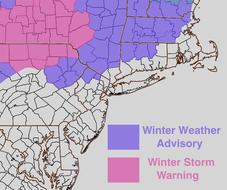
The NWS has issued corresponding watches and advisories for these areas — with winter storm warnings generally relegated to the far interior and winter weather advisories trickling into the interior areas of the big cities. The winter weather threat will be near zero in points south and east of there — as visualized on the map of winter watches and warnings.
Wind and Rain
A strong low pressure system tracking near the area will bring the potential for heavy rainfall from later today into Tuesday morning. Strong lift in the atmosphere will gradually shift northward today, through the Mid Atlantic and into the Northeast states. This lift will be accompanied by impressive moisture in the atmosphere, leading to the development of heavy precipitation.
A strong low level jet (movement of winds in the atmosphere) will also approach the region later on Monday and into Tuesday morning. This supports the development of torrential rain at times, with localized flooding especially in low-lying or poor drainage areas.
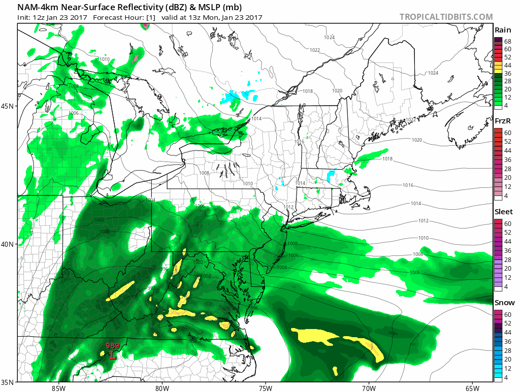
NAM model’s simulated radar imagery through Tuesday AM.
In addition to the heavy rain threat will come the presence of easterly winds — which will be quite strong, and enhanced by a high pressure to our north and a strong pressure gradient. The combination of dynamics in the atmosphere, a pressure gradient, and strong low level jet will lead to gusty winds later today. This will be especially true near the area coasts.
Winds may gust near 60mph for a few hours near the coasts, and the easterly winds may enhance the potential for coastal flooding. This potential is likely to be maximized from Monday afternoon through the early morning hours on Tuesday as the storm makes its closest approach to the area.
The National Weather Service has issued High Wind Warnings near the area coasts, with Wind Advisories (for gusts up to 50mph) a bit further inland.
Supplementary
Be sure to stay tuned through the afternoon and evening tonight for more information — including the latest information on the storm as it unfolds. Posts like this one are available multiple times each day to Personal and Commercial clients, including Zone Forecast subscribers. Contact us today for more info!