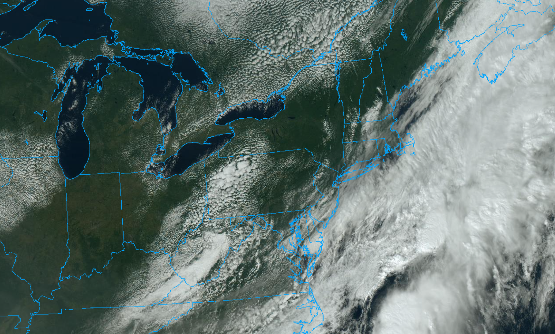
A cold front will sweep through the region this evening, ushering in some of the coolest air of the season. Dew points will fall into the 20’s and 30’s, with high temperatures only reaching the 60’s on Saturday. A northerly breeze will keep the air feeling crisp and cool. The front will also wipe away wildfire smoke, which has been lingering over the area since Tuesday.
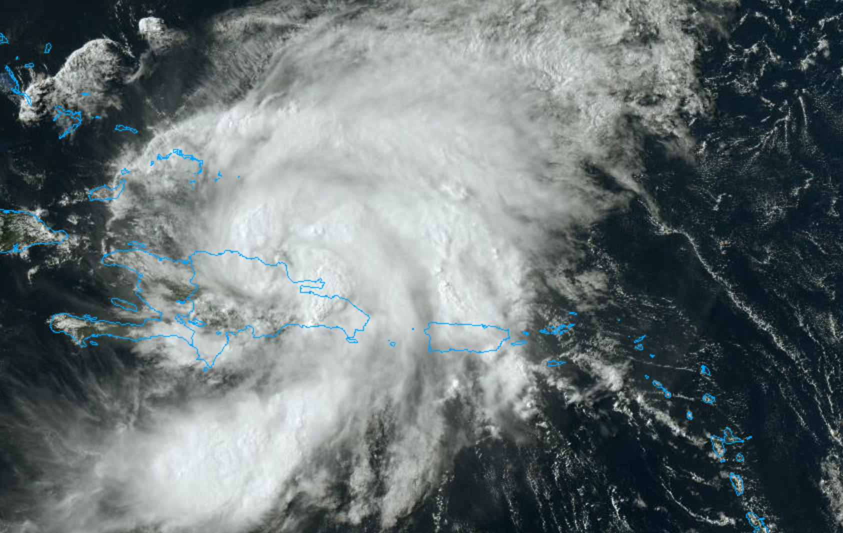
The National Hurricane Center issued a special advisory late Thursday night to announce that Isaias has strengthened into a hurricane. Currently, maximum sustained winds are at 75mph miles per hour. Hurricane force winds extend outward up to 35 miles away from the center and tropical storm force winds extend further outward up to 205 miles. Isaias will continue moving northwest into the open waters of the Bahamas on Friday.
Isaias will eventually turn northward towards the Southeast US coast early next week. The latest forecast from the National Hurricane Center suggests the storm will make landfall as a Category 1 hurricane along the Southeast US coast. Then the storm will track northwards towards the Mid Atlantic and Northeast coasts, but weakening to a tropical storm due to increasing southwesterly shear.
https://www.nymetroweather.com/wp-content/uploads/2020/07/Screen-Shot-2020-07-30-at-4.12.17-PM.png10661686John Homenukhttps://www.nymetroweather.com/wp-content/uploads/2024/02/Empire-2000-x-300-px-2.pngJohn Homenuk2020-07-30 17:12:352024-02-04 16:51:57Hurricane Isaias entering the Bahamas, will impact US East Coast next week
Warmth and humidity will persist in the NYC Area for the next few days, with temperatures in the upper 80’s and low 90’s. Potential Tropical Cyclone Nine formed in the Atlantic today, and will move towards the Caribbean this weekend.
QuickCast
This evening: A few showers and storms will move through the area, but coverage will remain low. Conditions are expected to improve this evening, with temporarily lower humidity. Expect lows in the 70’s.
Wednesday (7/29): Warm weather will continue, with light southwest winds. High temperatures will reach into the lower 90’s once again. No weather hazards are anticipated.
Thursday (7/30): Partly cloudy conditions will persist, with high temperatures near 90. Expect the chance for a few isolated storms, but weather hazards should be limited overall.
Forecast Discussion
A few showers and storms are moving through the region this evening, and will clear the NYC Area by early evening. Additional storms should develop across Southern and Central NJ later tonight, before the frontal boundary clears the coast. Expect improving conditions everywhere by morning. Partly cloudy and warm conditions will continue on Wednesday, with highs in the lower 90’s.
Multi-model ensembles show active conditions returning to the area next week.
The general trend through the weekend will be continued warmth, but slightly less oppressive conditions in terms of actual heat. Temperatures will reach the upper 80’s to near 90 each day, which is at least a few degrees lower than what we have been experiencing. Humidity will briefly decrease, but then rise again as we move towards Saturday and Sunday.
By next week, the chance for unsettled weather will return. Tropical moisture will begin surging northwards along the East Coast, and a disturbance will slowly approach the region from the Central US. Expect conditions to trend wetter and more unsettled by the middle of next week.
PTC9 Forms, Could Impact US East Coast
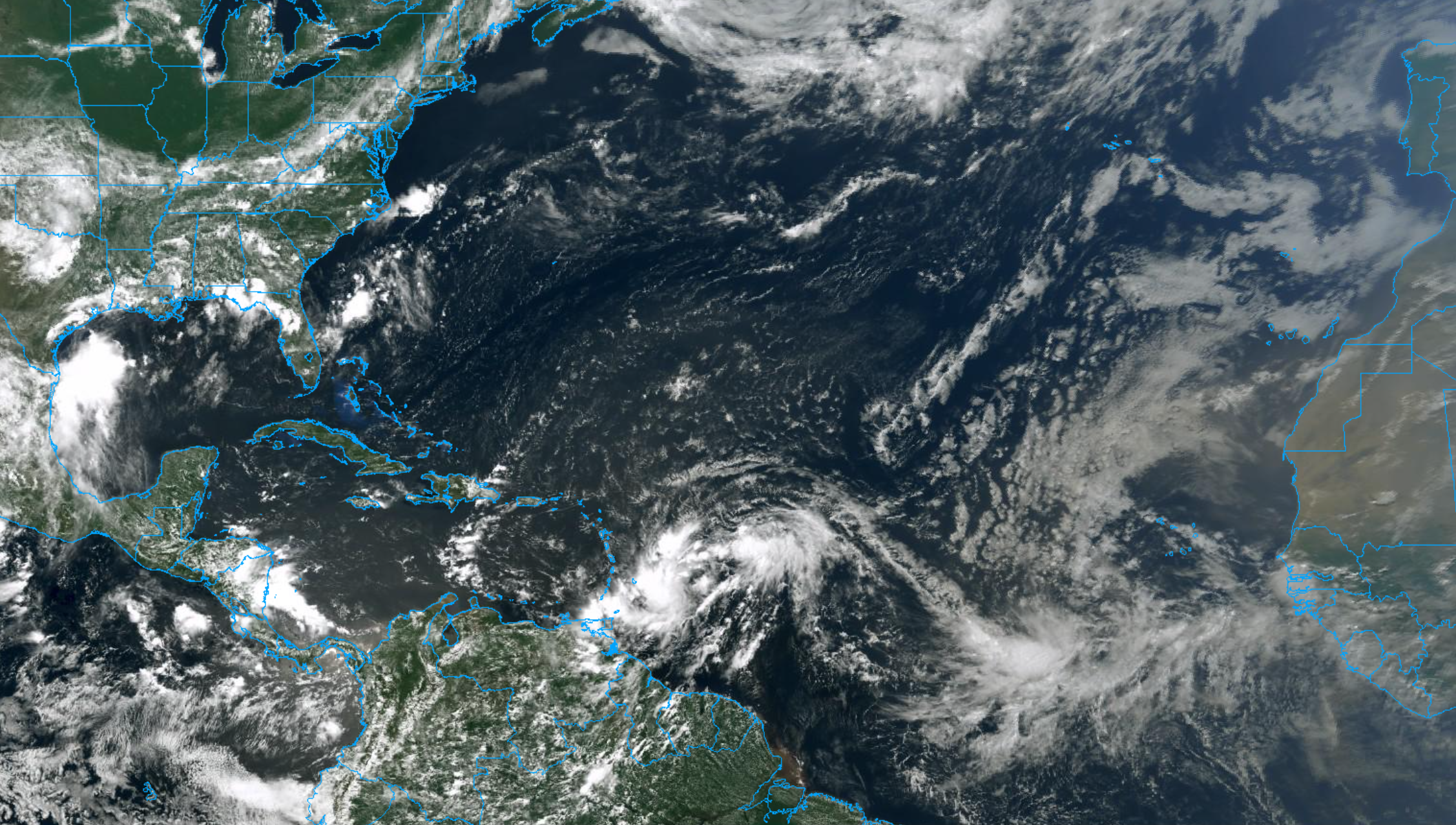
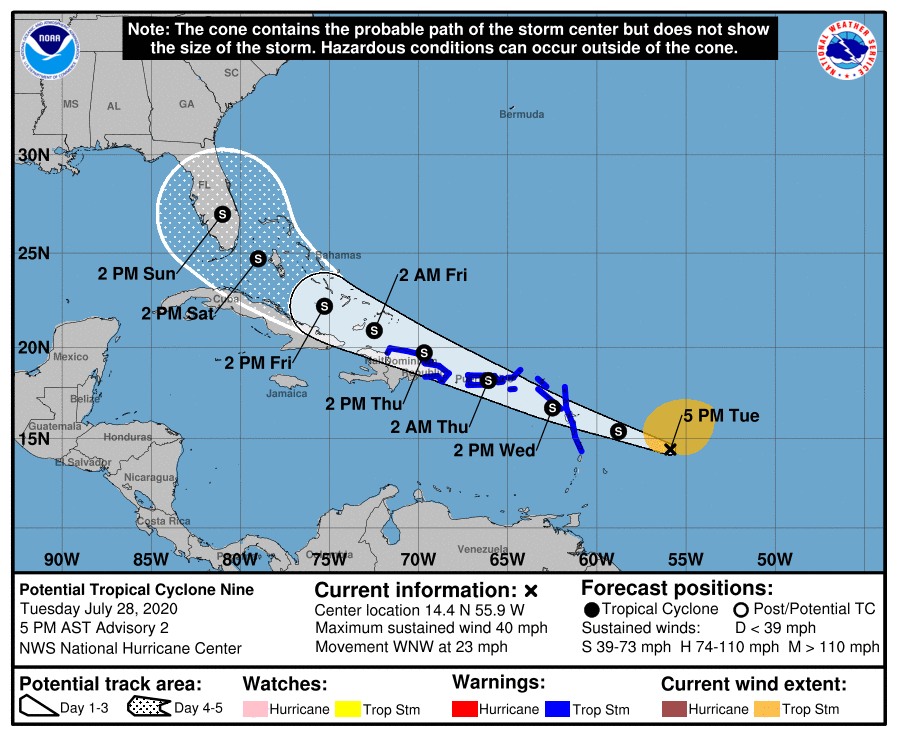
Potential Tropical Cyclone (PTC) Nine formed earlier today, designated by the National Hurricane Center. This system will move generally westwards over the next few days, on a path towards the Caribbean, while strengthening gradually. The system is forecast to strengthen into a Tropical Storm over the next 24-48 hours. If it does reach tropical storm strength, it will be named Isaias.
The eventual fate of the system, in terms of track and intensity, remains uncertain. The system is still in the process of organizing a center of circulation, and is battling the presence of some dry air from the Saharan Air Layer. This drier, often dust-filled air suppresses the development of thunderstorms within tropical cyclones and can lead to weaker systems overall.
Making matters worse is the fact that the storm will eventually approach the Caribbean Islands, possibly nearing a landfall in Hispaniola or surrounding islands. The rugged terrain of the islands in these areas has been known to weaken tropical cyclones in the past. Whether or not the system impacts these areas will obviously have a major impact on its evolution.
One thing forecast models have bene consistent on is that the system will eventually approach the US East Coast. The systems intensity, and the path it takes to get towards the United States remains to be seen. The National Hurricane Center currently forecasts a tropical storm to be approaching Florida by Saturday.
https://www.nymetroweather.com/wp-content/uploads/2020/07/Screen-Shot-2020-07-28-at-5.16.12-PM.png12782254John Homenukhttps://www.nymetroweather.com/wp-content/uploads/2024/02/Empire-2000-x-300-px-2.pngJohn Homenuk2020-07-28 17:18:592020-07-28 17:22:14NYC Forecast: Warm and humid, PTC9 forms in Atlantic
Highlights: Strong to severe thunderstorms are possible this afternoon and evening. Heat will continue through the weekend, and may peak early next week. Additional showers and storms are possible on Tuesday before temporarily cooler weather arrives.
QuickCast
Hazards: Thunderstorms could produce strong, gusty winds and dangerous lightning today. Excessive heat is possible on Thursday afternoon.
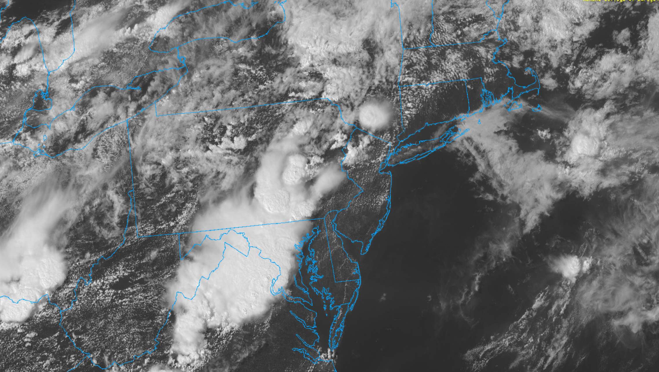
This afternoon: Showers and thunderstorms have developed across Eastern Pennsylvania this afternoon, and will shift eastwards through New Jersey and towards parts of the NYC Metro Area later today. Periods of heavy rainfall are expected from the late afternoon into the early evening as these storms shift into more substantial instability.
Hazards: Strong gusty winds, small hail, dangerous lightning, flooding
Timing: Through 10pm
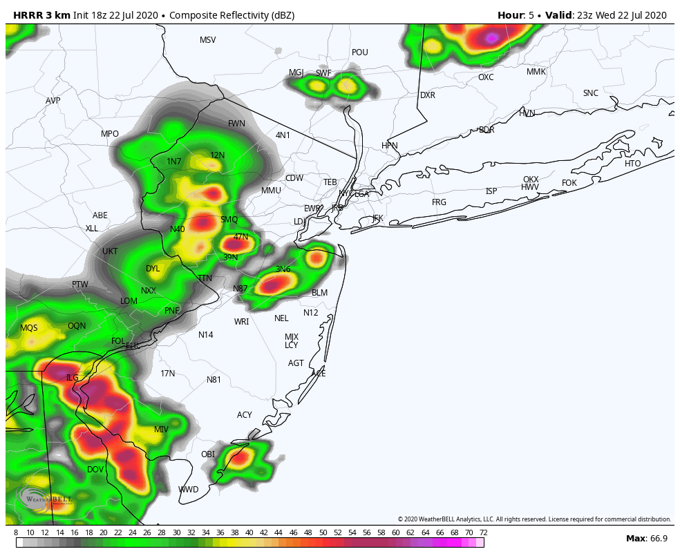
HRRR model showing strong and severe storms impacting the area later this evening.
Tonight: Showers and storms could persist into the early evening, but will gradually taper off. Lows will fall into the mid 70’s.
Thursday (7/23): Partly cloudy and more calm with slightly lower humidity. Highs will still reach the lower 90’s. Heat Advisory in effect during the afternoon hours for Heat Index values approaching 100 F.
Friday (7/24): Isolated to scattered showers and thunderstorms will be possible again during the afternoon and evening hours. Otherwise, the weather will be hot and humid once again. Partly cloudy, with highs in the lower 90’s.
Extended Forecast
Hot and humid weather will continue for a few more days, perhaps peaking on Monday when temperatures could reach the upper 90’s. Heat Index values could eclipse 100 F again. We anticipate Heat Advisories to be issued again by the National Weather Service as we draw closer. Active conditions will return by Tuesday, as a disturbance drops into the area from Canada. A front approaching the region could lead to showers and storms on Tuesday afternoon and evening, some of which could be strong to severe. Temporarily cooler weather (relatively speaking) is then expected by midweek.
Tropical Activity Returns
Tropical Storm Gonzalo formed earlier today in the Atlantic, and is expected to track westwards towards the Caribbean over the next five days. The system is expected to gradually strengthen, and could eventually become a hurricane. Additionally, Invest 91L in the Gulf of Mexico is expected to strengthen into a Tropical Depression at some point over the next day or so. This system should track westwards towards the Western Gulf of Mexico, perhaps eventually impacting parts of Texas with very heavy rainfall.
https://www.nymetroweather.com/wp-content/uploads/2020/07/Screen-Shot-2020-07-22-at-3.52.00-PM.png12842274John Homenukhttps://www.nymetroweather.com/wp-content/uploads/2024/02/Empire-2000-x-300-px-2.pngJohn Homenuk2020-07-22 15:54:262020-07-22 15:54:32NYC Area Forecast: Severe storms today, tropics active again
Hi friends! Our website uses cookies to provide an optimal browsing experience for you. New "Cookie Consent" laws mandate us to inform you of this. As long as you're cool with it, just hit OK. You'll only see this message once.
We may request cookies to be set on your device. We use cookies to let us know when you visit our websites, how you interact with us, to enrich your user experience, and to customize your relationship with our website.
Click on the different category headings to find out more. You can also change some of your preferences. Note that blocking some types of cookies may impact your experience on our websites and the services we are able to offer.
Essential Website Cookies
These cookies are strictly necessary to provide you with services available through our website and to use some of its features.
Because these cookies are strictly necessary to deliver the website, refusing them will have impact how our site functions. You always can block or delete cookies by changing your browser settings and force blocking all cookies on this website. But this will always prompt you to accept/refuse cookies when revisiting our site.
We fully respect if you want to refuse cookies but to avoid asking you again and again kindly allow us to store a cookie for that. You are free to opt out any time or opt in for other cookies to get a better experience. If you refuse cookies we will remove all set cookies in our domain.
We provide you with a list of stored cookies on your computer in our domain so you can check what we stored. Due to security reasons we are not able to show or modify cookies from other domains. You can check these in your browser security settings.
Other external services
We also use different external services like Google Webfonts, Google Maps, and external Video providers. Since these providers may collect personal data like your IP address we allow you to block them here. Please be aware that this might heavily reduce the functionality and appearance of our site. Changes will take effect once you reload the page.
-2")