-2")
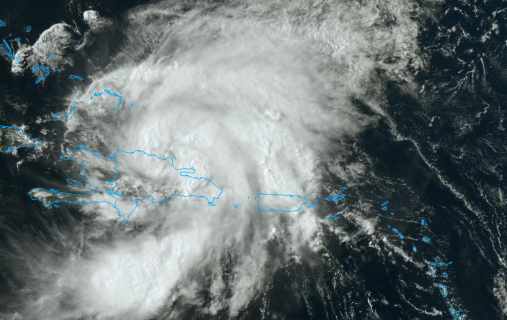
Hurricane Isaias entering the Bahamas, will impact US East Coast next week
The National Hurricane Center issued a special advisory late Thursday night to announce that Isaias has strengthened into a hurricane. Currently, maximum sustained winds are at 75mph miles per hour. Hurricane force winds extend outward up to 35 miles away from the center and tropical storm force winds extend further outward up to 205 miles. Isaias will continue moving northwest into the open waters of the Bahamas on Friday.
Isaias will eventually turn northward towards the Southeast US coast early next week. The latest forecast from the National Hurricane Center suggests the storm will make landfall as a Category 1 hurricane along the Southeast US coast. Then the storm will track northwards towards the Mid Atlantic and Northeast coasts, but weakening to a tropical storm due to increasing southwesterly shear.
Isaias to approach Florida this weekend
This weekend, Isaias is expected to move close to Florida’s eastern coastline. There is a considerable amount of uncertainty in regards to exactly where the storm will track. But most recent forecast model guidance has shifted towards making landfall somewhere along the Florida east coast on Sunday, before turning northward. Thus a Hurricane Warning has now been issued for a portion of the Florida east coast.
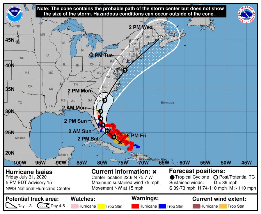
Model data suggests that the storm will be guided northward towards the Southeast US coast by early next week. The storm will be sandwiched between a trough over the Mississippi Valley, and a ridge in the Western Atlantic. As a result, the expectation is that Isaias will eventually move up the East Coast. Confidence has slowly increased in impacts along the East Coast, and the NHC is now forecasting Isaias to making landfall again in North Carolina on Monday, as at least a tropical storm.
Model guidance has come into better agreement over the past 12 hours regarding the eventual track of the system as it turns northward. Most ensembles, as of Thursday evening, suggest that the system will turn northwards towards the Carolinas, perhaps making landfall in North Carolina on Monday, and then continuing northwards towards the Mid Atlantic.
Eventually, Isaias will likely find itself somewhere off the Mid-Atlantic coast during the middle of next week. It remains to be seen exactly how close the storm will come to the New Jersey or New York coastlines and how strong it will be. But a more westward track, closer to the coast, could lead to substantial impacts in parts of the area. A track further east, or further out to sea, would limit impacts overall.
How NYC could be impacted
At this range, it goes without saying that impacts from Isaias in NYC – if any occur at all – remain uncertain. It will take a few more days to pin down the details of Isaias’ evolution as it moves up the East Coast. Still, the possibility of impacts from Isaias in NYC has increased over the past 12 to 24 hours. The area could actually be impacted by the storm even before it approaches the Southeast US coast thanks to a feature called a Predecessor Rain Event, or PRE.
A PRE occurs when jet dynamics enhance the movement of tropical moisture ahead of a tropical system. As a result, tropical rainfall can occur hundreds of miles away from the center of the actual tropical storm.
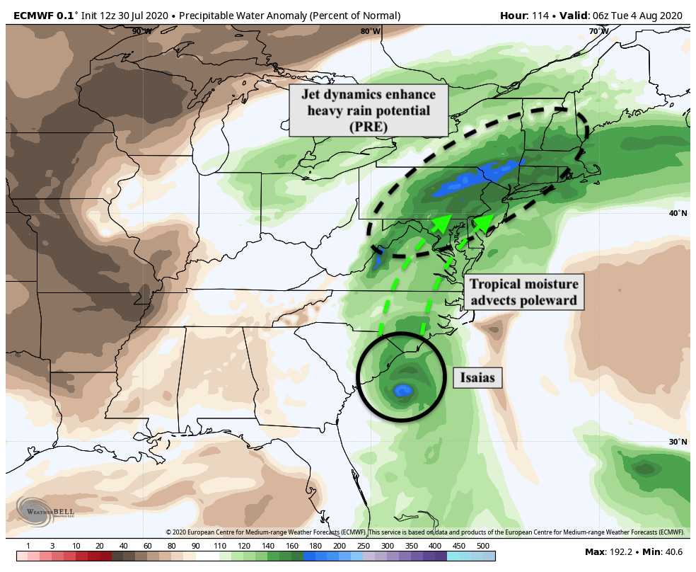
Recent forecast model guidance has suggested the possibility that a PRE could develop across New England next week, even while Isaias is still located off the Southeast US coast. Should this occur, heavy rainfall and flooding would be a concern by early next week throughout New England.
In addition to the PRE, the track of the storm obviously is a focal point for potential impactful weather as well. Recent ensemble guidance suggests that the storm may eventually find itself off the waters of New Jersey and New York next week, which would lead to the potential for additional heavy rainfall, gusty winds, and rough seas.
Stay tuned for further updates in the coming days as confidence begins to increase regarding the systems intensity and track.
Leave a Reply
Want to join the discussion?Feel free to contribute!