-2")
Tracking a Couple of Light Snow Events Next Week
Winter is finally about to make a return to the Northeast, and given that we are nearing the peak climatology period for snow, this often comes with snow threats. Often times, though, in an initial pattern change, the pattern becomes cold and dry for a period. And while it’s certainly a possibility that we will be cold and dry for a while, there has been increasing evidence that we may be tracking 1, 2, or even 3 light snow events in the next week or so. It all starts with an amplified PNA ridge in the western half of the US that greatly interacts with a lot of disturbances in Canada. This forces these disturbances to interact with this ridge and slide down into the Central US and try to amplify in the Tennessee Valley and gain moisture in the process. This is how you can get a little clipper event to turn into something more substantial.
Initially, the flow is very compressed and elongated in the South and in the Atlantic. This will serve to prevent any phasing with STJ moisture and also try to send any low pressure that forms well out to sea. So the moisture development and getting a low pressure to pop close to the coast may be almost entirely dependent on the amplitude of the PNA ridge and the interaction of the shortwaves as they initially enter the US, which means moisture may be hard to come by.
There is a large ridge in the South Atlantic, and also a vortex lobe south of Greenland. Together, they create a tight, fast gradient in the Atlantic that runs SW to NE, which makes it hard for a storm to truly amplify right off the East Coast, as the “steering” flow is generally out to sea. But since we now have to focus on the PNA ridge and shortwave interaction, it is prudent to look at the trends with this ridge on the last several runs of the GFS.
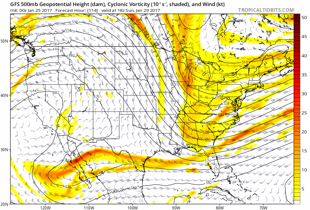
The past several runs of the GFS have trended much more amplified with the shortwaves coming down from Canada (Tropical Tidbits).
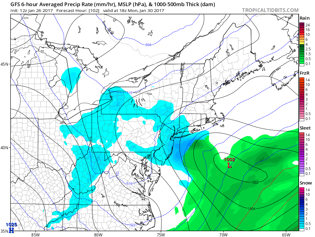
This weekend, it appears likely that the first strong shortwave will be diving down from Canada and into the US. But often times since these shortwaves start off in such data-sparse regions, the models miss their amplitude and interaction, and thus show a flatter, further east wave that does nothing to buckle the flow. But notice how in the past several runs, there has been a significant trend for this energy to be more amplified, and thus drop down much further southwest, and is able to interact with a second area of vorticity diving down from Canada. That forces the PNA ridge to buckle more and take a more north-to-south orientation, which means we can get a more defined positive vorticty advection axis in the Tennessee Valley turned more favorably up the East Coast. Thus, despite the fact that the initial jet is well offshore, we can get enough lift in the atmosphere closer to the coast to force pressure falls close to the coast as well, and you can get a “mini low”/inverted trough type of feature. The 12z GFS shows this scenario well and gives the area 2-4” of snow. Other models have this inverted trough as well, but are further east with it.
Today’s 12z GFS valid for Monday shows a light snow event for the area (Tropical Tidbits).
While further trends in the above regard could actually result in a decently-sized snowstorm, the trends in this regard are not always linear in a situation where there is no Atlantic blocking. There could just as easily be a new kink to the lobe near Greenland that pulls the trough axis and tight Atlantic gradient even further east, which would cancel out the trends with the PNA — the energy would again be forced to dive too far east to give the area snow. Thus, we are not ready to pull the trigger on an accumulating snow scenario, though we will be watching this closely.
But there are 1 or 2 other light threats right after this that we are watching as well, given the constant supply of shortwaves from Canada entering the US. After the Monday event pulls away, the PNA ridge flattens a bit and instead is replaced with a ridge off the NW Coast. That may allow one or two disturbances riding along an Arctic front to get sent towards the Upper Midwest and towards our area, but not necessarily dive well to the south. There may be just enough cold air behind Monday’s storm, though, to send these impulses just south enough to get snow into the region or even re-develop a small coastal low for precipitation enhancement. Otherwise, the flattening PNA ridge may mean the storm rides too far north and doesn’t get a good moisture supply.
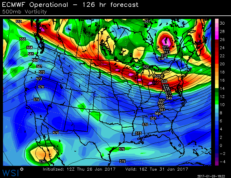
Today’s 12z European Model valid for Tuesday through Wednesday of next week shows multiple impulses that could give the area a couple shots of light snow (WSI Model Lab).
If there is separation with this energy, then the lead energy will be moisture-starved, but could give some light snow showers on Tuesday, while giving the trailing energy a bit more room to amplify and thus drop a decent swath of light snow on Wednesday. There may be just enough of the PNA ridge left along with meridional energy downstream of the EPO ridge for this to happen. Today’s 12z ECMWF model showed this scenario: an elongated lead wave but a separated potent shortwave entity trailing it, giving accumulating snow on Wednesday. But given the fast west-to-east jet riding into Canada and the flattening PNA ridge, these impulses may stay elongated and thus have no center of defined lift, which would keep things dry.