-2")
1/31/17 AM All Zones: Some Snow, Especially for Northern Areas Today
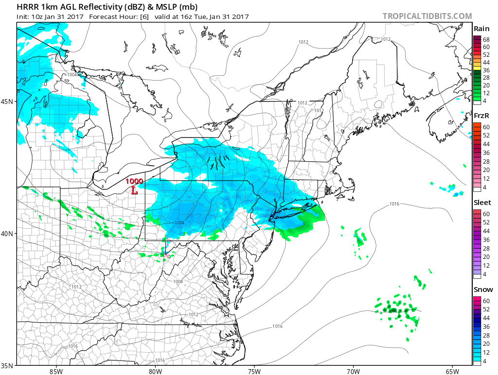
Skies will remain mostly cloudy today, as a clipper system coming out the Great Lakes. Snow is still anticipated for many parts of the region, especially north of Central New Jersey. Primary low pressure will weaken and stay northwest of the region. While a secondary low begins forming just south of Long Island and then tracks northeast over Cape Cod or Nantucket regions during the evening hours.
Snow will begin breaking out from west to east across much of the region between 8am and 11am this morning then continues into at least the early afternoon hours. This is primarily due to isentropic lift, from warm-air advection the mid-levels of atmosphere occurring over a colder airmass remain more stubborn near the surface. Surface temperatures will be in the 20s and lower 30s during this band. So some light accumulations are likely, north of Central New Jersey
But some frontogenesis along a thermal gradient and from the left front quadrant of jet streak, at the 850mb level or several thousand feet in the atmosphere, could enhance lifting for some bands of moderate snow by late this morning and early afternoon.. This is appears mostly likely to occur just north and west of NYC. Where snowfall totals are expected to be between 1” to 3”. Closer to NYC and Long Island accumulations are currently expected be closer to 1″ or less. This will depend on how long steadier snow lasts, how cold surface temperatures area, and where moderate banding occurs. Individual zone mesoscale updates may be needed later today, for these moderate bands. Driving could become more hazardous today with reduced visibilities near or under 1 mile and some snow accumulation on roadways, again especially northwest of NYC.
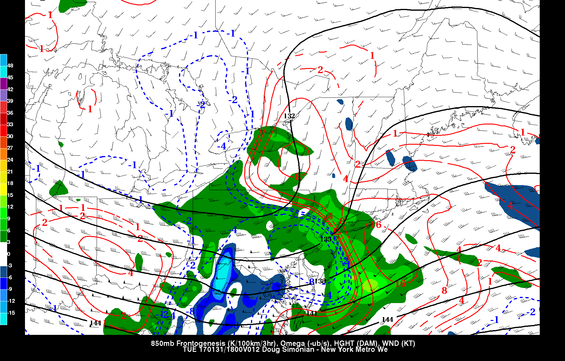
NAM showing 850mb frontogenesis and vertical velocities (lift) mover through region with area of snow
Then as the warm front starts lifting north into Central NJ, best dynamics and moisture will shift further north, ahead of a dry slot and more warm air. This will cause steadier snow to taper off to intermittent snow showers or flurries during the mid-late afternoon hours. First over NYC and Long Island then further north over Northern New Jersey, Hudson Valley and Connecticut.
Enough warm air in lower and mid-levels may even cause snow mix with some rain before ending in areas south of NYC, by early this afternoon. Surface temperatures may rise well into the 30s or into the 40s over Central and Southern NJ, and Southeast PA zones this afternoon. With less banding and warmer temperatures very little snowfall accumulation if any accumulation is expected for these zones.
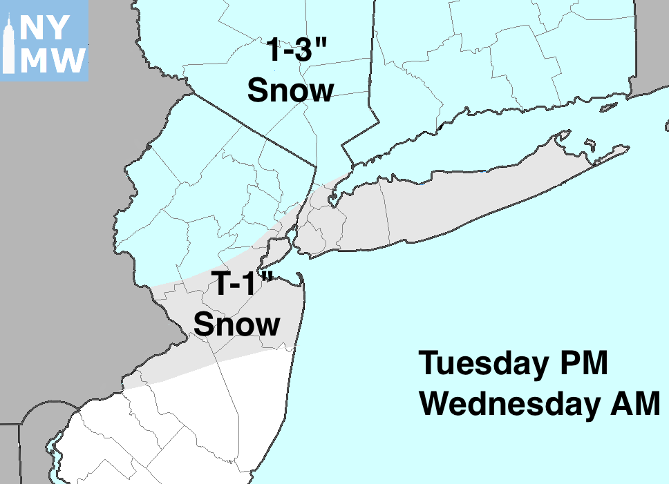
Latest Snowfall Totals Forecast for Tuesday 1/31/17
Any linger snow showers will taper of this evening, low pressure moves away from the region. Partly cloudy skies are for tonight with lows dropping back down into 20s or lower 30s across the region. More tranquil weather expected for the rest of the week. Temperatures will be closer to normal on Wednesday. Then temperatures drop to below normal level, each day through Friday and Saturday. Next storm system for next Sunday into Monday, we’ve been been trending weaker with less impacts in the region, on the latest model guidance. But we will continue to watch it. More updates will be coming out later today!