-2")
1/6 AM All Zones: Multiple storms affect the area this week
At least two disturbances are expected to move through the area during the upcoming work week, with the first one arriving on Tuesday and the second following right behind it on Thursday morning. Both will be moving rather quickly, through a fast and progressive atmospheric flow in both the mid and upper levels. But they will be different in nature — with the disturbance on Tuesday providing rain to the entire area, while Thursday’s storms holds wintry prospects.
A low pressure system drives well to our northwest from late tonight into Tuesday, over the Great Lakes and Southeast Canada. Warmer air in all levels of the atmosphere will take over, with southwesterly winds in much of the region. Precipitation will start and end as rain, beginning on Tuesday afternoon and ending during the morning hours on Wednesday.
Rain will be sporadic, but periods of steadier rain cannot be ruled out. No flooding problems are currently anticipated, aside from typically poor-drainage areas or low lying parts of the region. Behind the system on Wednesday, improving conditions are expected. Westerly flow behind a cold front will usher in a colder airmass as well.
Looming to the southwest, however, is a second atmospheric disturbance in the mid levels of the atmosphere. This disturbance, will not tremendously strong or aggressive, will move through the Mid Atlantic states from late Wednesday into Thursday. Forecast models have wavered dramatically with its intensity and the resulting low pressure track and intensity.
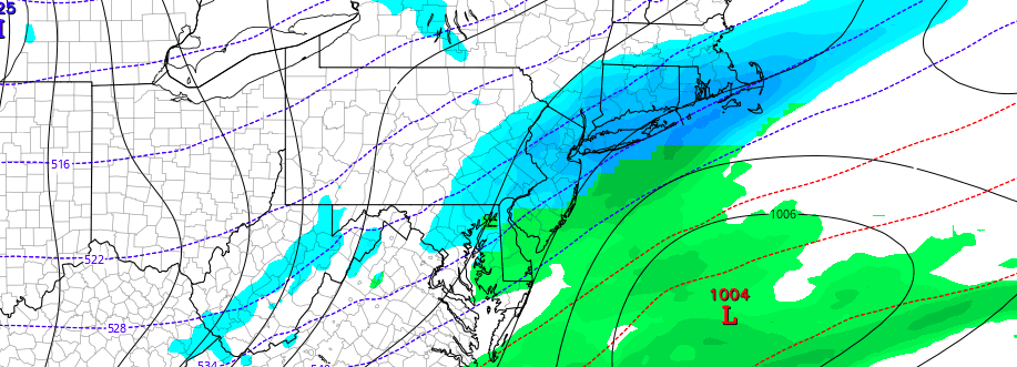
The latest models from last night and this morning suggest a stronger low pressure area, nearer to the Northeast Coast, with bands of snow moving inland over the Northern Mid Atlantic and New England. Previous runs had shown a much weaker and less impactful system. There are a few things to remember here: While the system is entirely possible, a track favoring snowfall isn’t yet supported. A fast flow in the atmosphere still exists, despite the presence of a ridge in the West Coast.
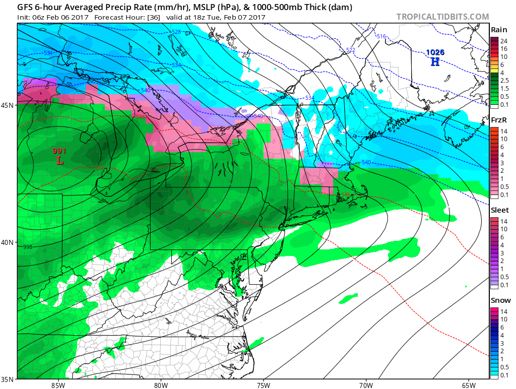
GFS model showing the evolution of multiple disturbance affecting the area this week.
Additionally, there is no impetus to prevent the storm system from taking a track even further west. Here’s what we’re trying to say: A storm track in the perfect location for our region to see a widespread snowfall, while appearing on forecasting models, isn’t exactly expected at the moment. However, it is possible that a light to moderate snowfall occurs on Thursday.
The ECMWF and GEFS ensemble mean tracks both take the storm system from the Delmarva to a position off the NJ Coast and eventually southeast of Southern New England. This favors the potential for light snowfall in our area, even near the coastal plain. Continue to monitor forecasts over the next few days, and we’ll have many more updates in that time frame as well.