-2")
AM All Zones Update: Significant Snowfall Expected Late Tonight into Thursday
A warm front will likely make little progress northward this morning, before a cold front moves through during the midday hours today. Drier northwest winds behind this front, will cause low clouds and fog to clear for more sunshine later this morning and afternoon. Temperatures will still rise into the 50s and some even lower 60s this afternoon, with a downslope flow. Then a colder airmass will begin moving into the region tonight.
Shortwave energy phasing along an amplifying trough, will result deepening area of low pressure to develop along a frontal zone over the Virginia and Maryland. Precipitation will start breaking out after midnight, as this low moves east and increases isentropic lift along a thermal gradient. Boundary level temperatures may still be warm enough to support some rain and/or sleet at the start, especially south and east of NYC. But with more cold air advection and dynamic cooling, all precipitation should become snow across the entire region by around daybreak. Some light snowfall accumulations are likely, before sunrise, especially away from the coast.
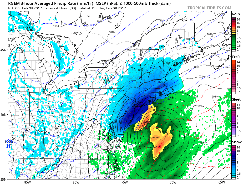
Early morning GFS model moderate to heavy precipitation coming into region as temperatures drop below freezing by 7am Thursday
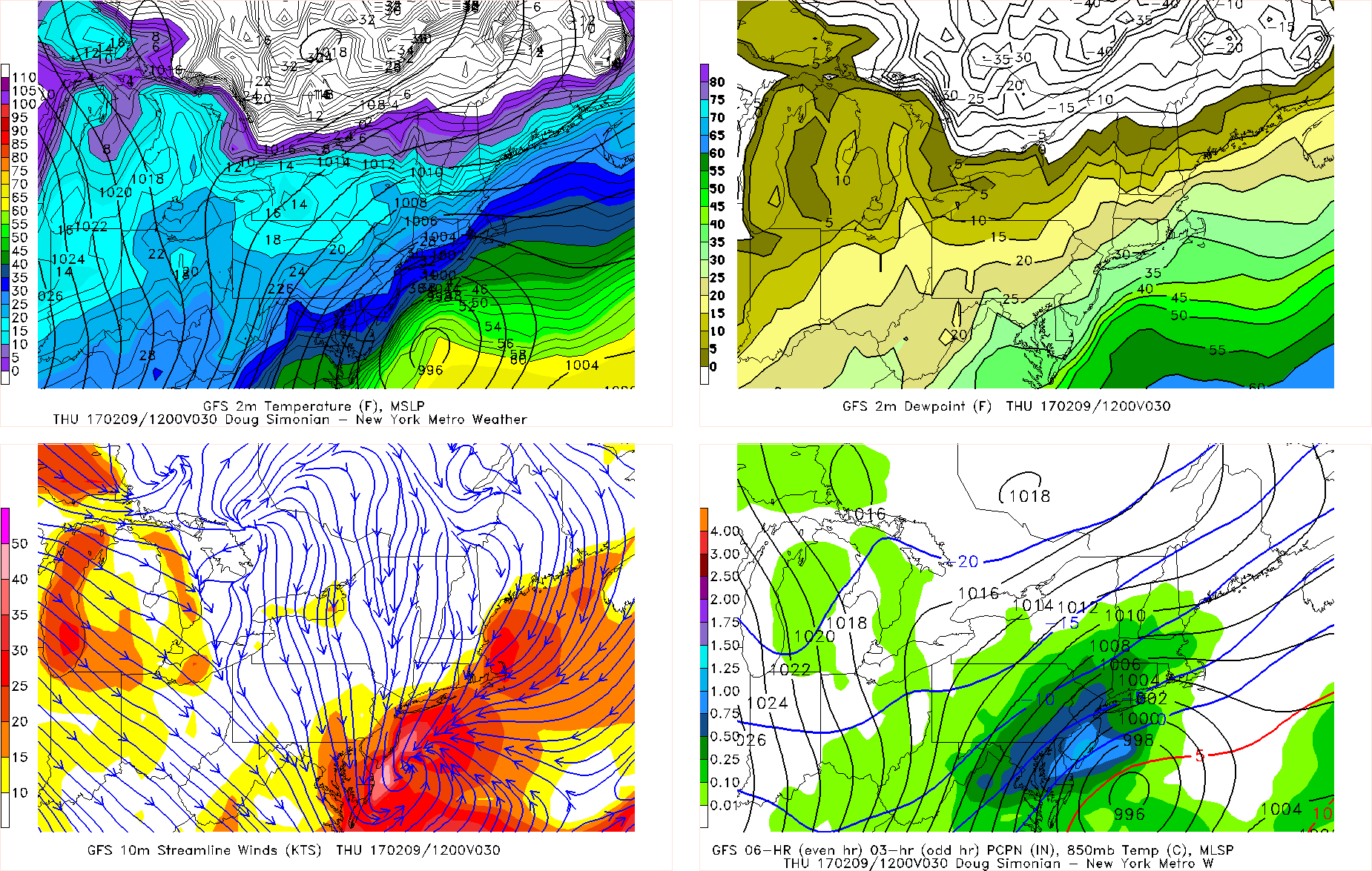
Strong divergence from dual upper-level jet will cause low pressure to intensify rapidly just off the New Jersey and Delaware coast tomorrow. With this low gain more dynamics and moisture, snow become moderate to heavy at times, during the morning commute on Thursday Increasing northerly winds with gusts between 25 to 35mph, will cause temperatures will be drop into 20s over much of the region. So snow will be accumulating more rapidly on roadways and reducing visibilities to under 1 mile.
Model guidance indicates very intense frontogenesis will be over parts the region tomorrow morning. This is a signal for deformation band with snowfall rates around 2” to 3” per hour and possibly even some thundersnow. There is a little more uncertainty this morning where this band will be most profound of the region, as overnight models shifted a little further east and faster. But underneath this band, snowfall totals of 10 inches or higher are most likely to occur, before snow ends later in the day.
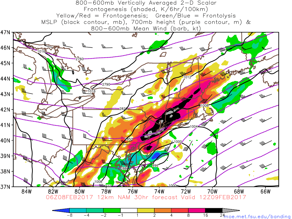
The NAM model continues to show very intense frontogenesis (black and gray areas), resulting in banding with very heavy snowfall rates tomorrow morning
Snow will begin winding from west to east across the region during early to mid-afternoon hours tomorrow, as low pressure will be moving out quickly further offshore. When it’s over, a significant snowfall of at least 6″-10″ appears likely for much of the region. However, it is still possible that some sleet/rain at the onset or less banding could reduce snowfall totals in some areas, particularly farther outside of the I-95 corridor. While locally heavier snowfall totals are possible in other areas. The snowfall map issued yesterday for all zones, will be updated later this morning. as new data comes in.
Skies clear tomorrow night. But a frigid airmass will be coming in behind this storm. Lows may get into teens and with perhaps some single digits over much of the region. Friday be very cold and partly sunny with weak high pressure briefly over the region. Highs will be in the upper 20s to lower 30s. Then a weak clipper may passing to north produce some snow showers or period of light snow Friday night. Temperatures will being moderating this weekend with higher mid-level heights and more southwest flow. Some light precipitation is possible again Saturday night and Sunday with a warm frontal boundary near the region. Stay tuned for another zone forecast update this afternoon!