-2")
PM Zone Update: Multi-day winter weather in New England
A multi-day (and multi-disturbance) winter weather event will unfold across New England over the next few days, with central and northern parts of New England in line for several inches or more of snowfall. Multiple disturbances in the atmosphere will traverse from the Great Lakes and Ohio Valley into the Northeast, with coastal low pressure systems forming in multiple fashions. The first moves from our southwest on Saturday evening into Sunday morning, and has trend more significantly in terms of wintry precipitation. Much of this can be attributed to the snowpack in place across the interior — keeping low level cold temperatures locked in more effectively.
Warm air both in the mid levels and at the surface will be moving north from the Mid Atlantic states as Sunday morning approaches. But moisture and lift, effective in developing precipitation, will move northward as well, allowing wintry precipitation to break out across the region. Across Northeastern PA, Northern NJ, NYC and LI, precipitation may begin as snow and sleet – remaining a wintry mix for a few hours before a transition to rain occurs. The wintry mix will occur longer across the interior and higher elevations of NJ, SE NY, and CT where low level cold air will remain more stout. Here, freezing rain and sleet are possible for a more prolonged period of time.
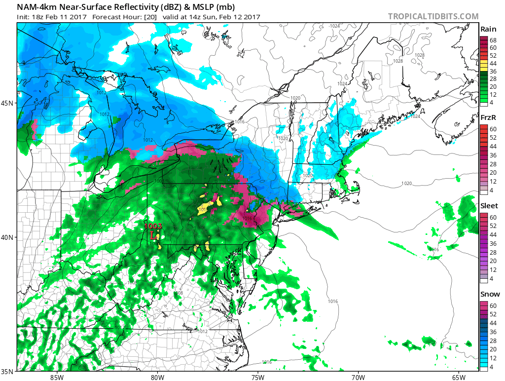
NAM model showing the forecast evolution of the storm from Saturday PM into Monday.
Across New England, snow will be much more prevalent, and will continue through Sunday. Moisture and lift in the atmosphere will expand as a low pressure system develops south of Long Island and moves off the coast of New England. This will allow a prolonged period of snow to occur. Meanwhile, a second disturbance from Southeast Canada will be driving southeastward, and will phase in the mid and upper levels of the atmosphere across New England, adding dynamics to the already strong disturbance over the area.
This will aid in the development of a rapidly deepening low pressure off the coast of New England. The low pressure area will strengthen quite significantly from Sunday into Monday. Very heavy snow is likely across parts of New England – particularly Northeastern Massachusetts into parts of New Hampshire and Maine, where blizzard conditions are possible for a prolonged period of time through Monday afternoon and evening. The storm will have pulled away from interior New England and the northern Mid Atlantic by this time.
Timing and Impacts
Saturday Night: Wintry precipitation moves northwards from the Mid Atlantic states. Snow breaks out across Northeastern PA, Northern NJ, Southeast NY and parts of CT. Precipitation changes to a wintry mix gradually across the aforementioned areas with light accumulations.
Sunday Morning: Wintry precipitation continues to spread into New England. Wintry mix changes to rain across the Northern Mid Atlantic (NE PA, NJ, NYC, S CT) Rain eventually ends here by later in the day. Wintry mix continues across Central CT while snow continues in new England.
Sunday Night: Snow in New England continues, heavy at times, and becomes significant during the evening across Eastern New England as a low pressure system rapidly deepens offshore. Heavy snow with blizzard conditions occur overnight in Northeast MA, Southeast NH and Maine.
Monday Morning: The event begins pulling away with snow continuing across Eastern New England until the middle of the day.
Our overall “impact” map for the storm system is included below. This includes the entire event — from late Saturday Night through Monday — and delineates the areas where we expect the most significant wintry weather to occur. It is important to note that local variations in impacts will occur. The southern extent of the wintry impacts in NJ and NYC is particularly uncertain, as forecast models have trended cooler over the past 24 hours to suggest that a slightly longer period of snow or sleet is possible there.
Stay tuned over the next several hours for more updates, including a mid-evening update tonight on the initial wintry surge over the Northern Mid Atlantic states.
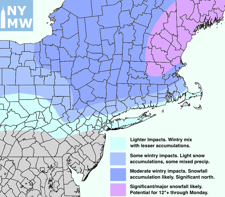
Impact map for wintry weather through Monday.