-2")
Technical: Strong to Severe Thunderstorms Likely Late This Afternoon
After some record warmth over the past few days, we are about to get our usual strong cold front “snap” back towards seasonable temperatures. But considering how warm and moist the atmosphere is initially, this means there will be quite an impressive temperature gradient, which is often a great fuel for storm development. Although the severe weather event in the Ohio Valley greatly underperformed (as expected), that does not necessarily portend an under-performer further east. While things do not necessarily lead to a major severe weather outbreak, the recent model guidance has actually trended a bit more impressive with a line of thunderstorms for late Saturday afternoon.
The reason this is happening is because there is a lot more backed low-level flow in our area compared to what the Ohio Valley had, meaning the surface winds are bending back to the southeast instead of the southwest. This adds more directional wind shear to the profile, considering winds just above the surface turn southwest — so that southeast to southwest turning with height provides some low-level rotation and thus a bit more organized updrafts. Additionally, there is a well-timed increase in the 850mb jet and lower just ahead of the strongest convection, allowing the line of thunderstorms to maintain its strength.
The general setup is a large low pressure system along the cold front back into the Ohio Valley that moves into Southeast Canada. Out ahead of this low is a strong cold front that drags down to the southeast. Ahead of the cold front is a nice warm sector of warm and somewhat unstable and moist air, which could be pretty buoyant. Behind the cold front, you have plenty cold mid-level temperatures, but those advect from behind the cold front to ahead of the cold front and into our area — the warm sector — because the mid-level winds are so strong. This means you are coupling a warm surface with a cold mid-levels — a good temperature profile for generally rising, condensing air. While the mid-level temperatures are somewhat moderated compared to the Ohio Valley — meaning the mid-levels are a bit less unstable than it was in the Ohio Valley on Friday — they are still sufficiently unstable for thunderstorms.
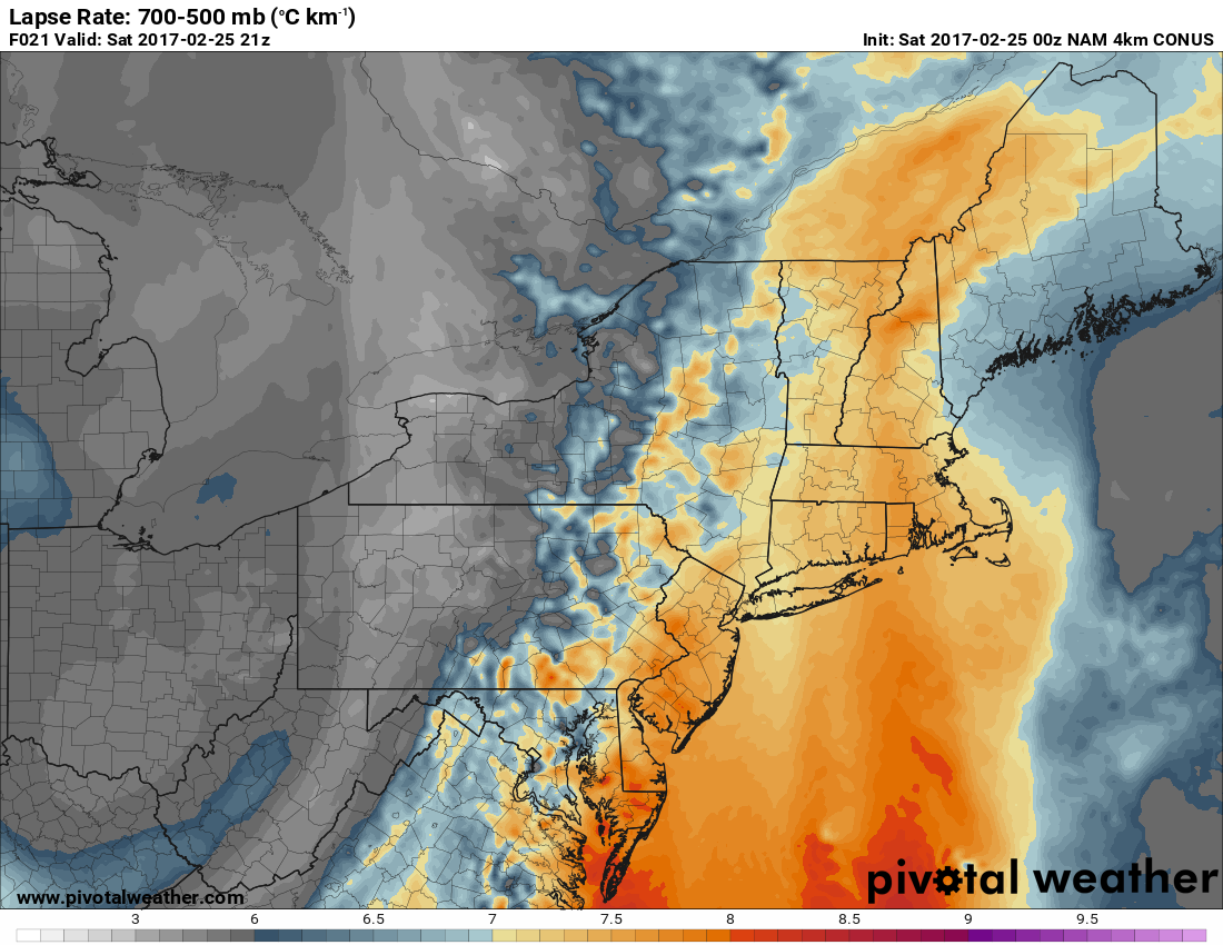
The 00z 4km NAM run valid for 4pm Saturday shows mid-level lapse rates around or above 7C/km. This might be overdone a bit, but it does show that mid-level instability is sufficient for severe thunderstorms (Pivotal Weather).
As the cold front moves east towards Central PA, there are a couple of nuances to the surface pressures that add plenty of intrigue to this setup. Instead of one large low pressure system dominating the pressure field making the winds southwest out ahead of it, we instead have a tighter, but still large pressure trough, which allows winds to back more to the southeast out ahead of it via more kinks in the isobars. Additionally, there is a low pressure offshore of the Mid Atlantic and a large high pressure system northeast of that, which creates an enhanced, bent back pressure gradient towards the coast. This means that the surface winds from the offshore low would initially tend to be northeasterly — which is poor for moisture convergence — but then when that offshore low pressure feels the effects of the higher pressures to the northeast as well as the pressure trough back to the west, the winds are forced to bend back to the southeast. And not only does this add the aforementioned directional wind shear with height, but it also helps to add more Atlantic moisture.
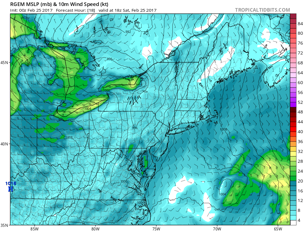
The 00z RGEM run valid for 1:00pm on Saturday shows a very nice pressure trough in the Adirondacks and Appalachians, as well as an offshore low underneath higher pressures, all contributing to increased southeast surface winds (Tropical Tidbits).
Thus, the fact that we have three factors combining for southeast flow, as well as an oncoming strong cold front that these southeast winds run into, you get strongly enhanced moisture convergence, via moisture from the front converging with moisture from the greatly enhanced onshore/southeast flow. This is something that the Ohio Valley did not have, and could make a difference with regards to the strength of these thunderstorms, and even allow maintenance of strong to severe thunderstorms to the coast, despite weakening instability as one heads towards the coast.
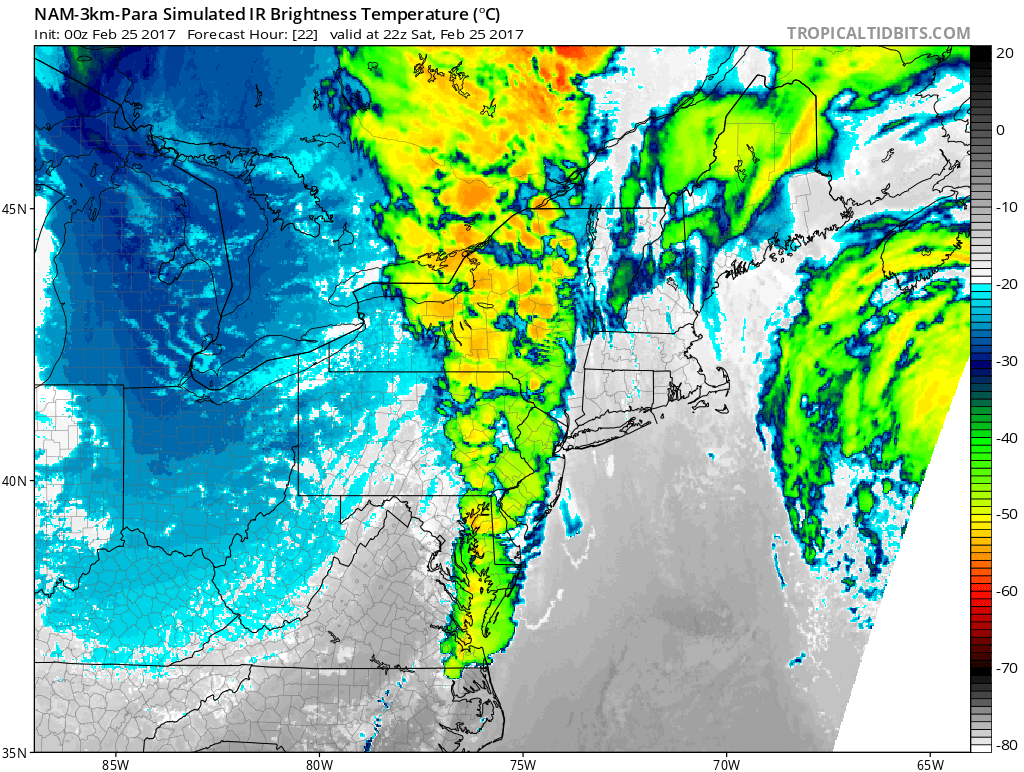
The 00z NAM run valid for 4pm shows very impressive low-level moisture convergence (red contours) along the cold front and line of thunderstorms.
This extremely organized area of high moisture convergence is a classic indicator for a strong line of thunderstorms to form in Eastern PA and maintain its strength as it heads into NYC. But the instability does wane a bit as one heads towards the coast, as along the coast, southeast winds mean more of a marine layer — so the moisture comes at the expense of instability — but inland will have the same southeast winds yet warmer temperatures/no marine layer, so the moisture convergence does not come at the expense of instability. Thus there may still be some inherent weakening along the coast. However, because of the aforementioned trends with the pressure trough, and the offshore low and high pressures, there may be increased dynamics along the coast. This is because as the offshore low strengthens and phases into the main disturbance, the pressure gradient actually increases further south, leading to an increased low-level jet. When this is also combined with the fact that the Ocean has much less friction than land, the low-level jet can really strengthen right along the coast, which yields increased dynamics and lift to compensate for the lack of thermodynamic instability.
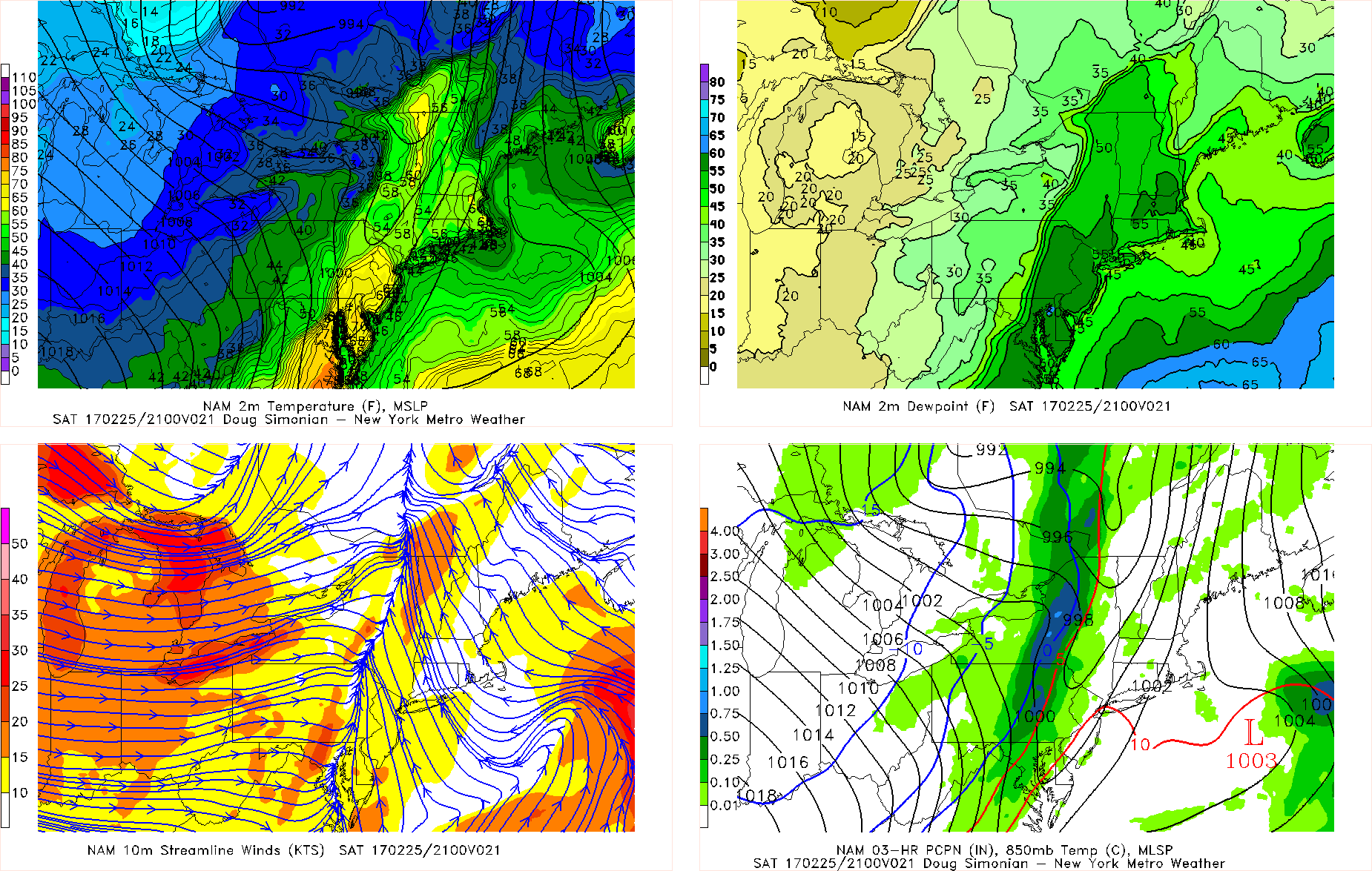
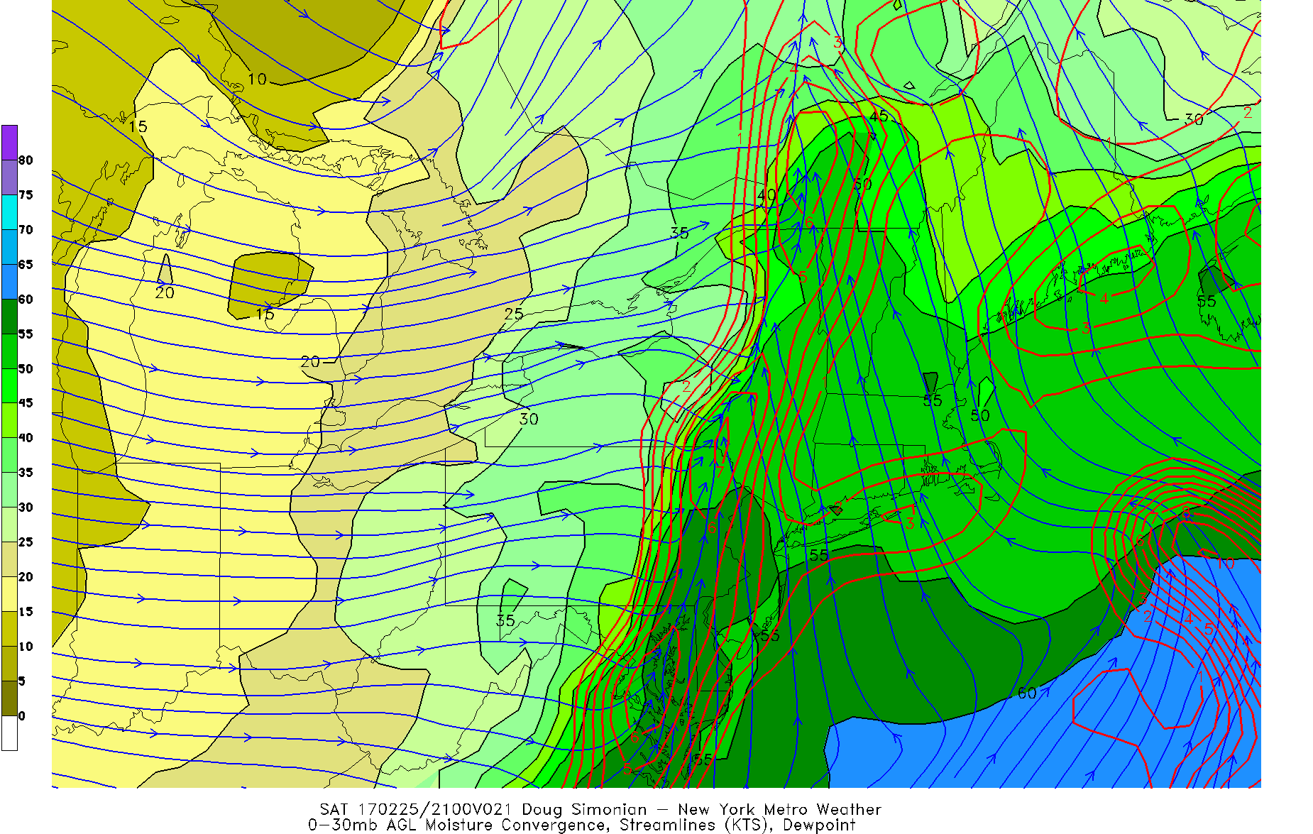
The 00z NAM run valid for 4pm also shows a good pressure trough, as well as a very impressive convergence boundary in E PA.
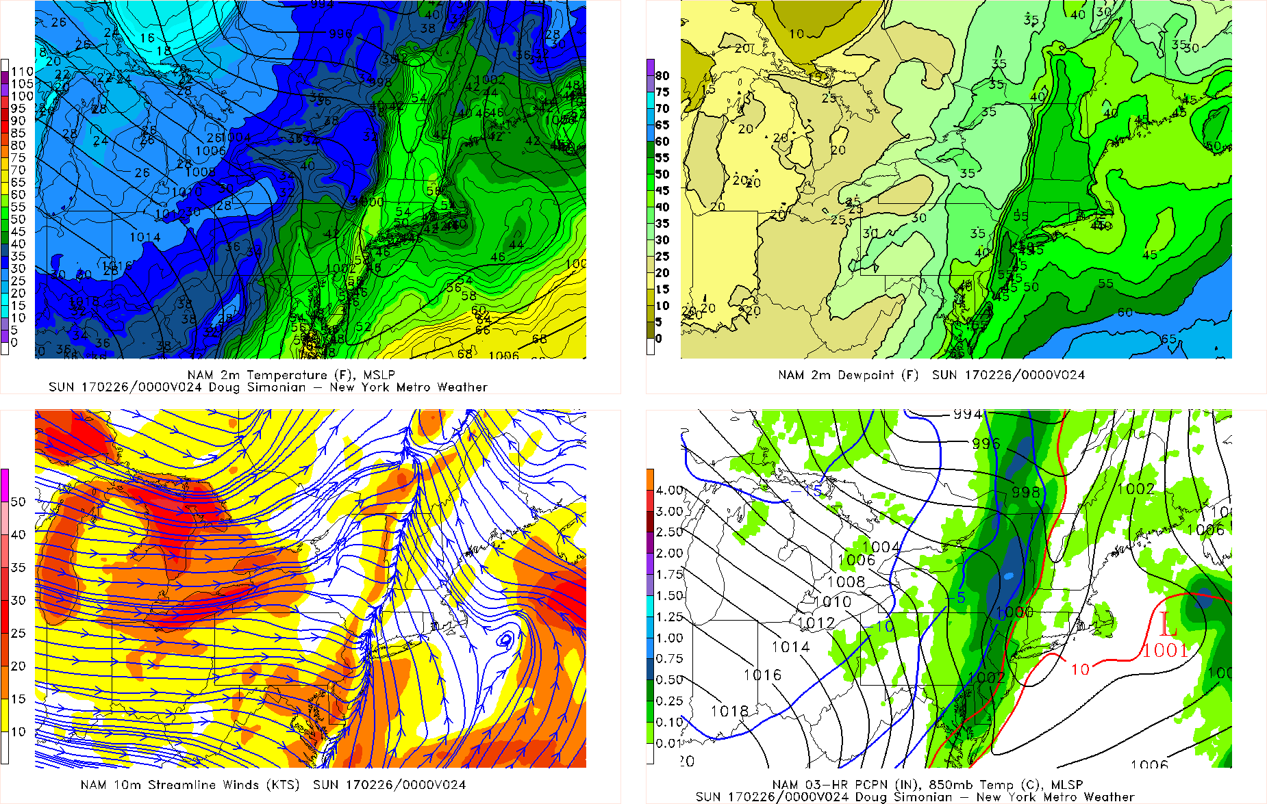
The 00z NAM run valid for 7pm shows a strengthening of the convergence boundary along the coast, which may help the line of thunderstorms maintain its strength.
Also notice how the westerly winds behind the convergence boundary also increase in strength — there is a second strong westerly push to the low-level jet. This may also help keep the winds with this line of storms at pretty strong levels even if the storms themselves do in fact weaken when they reach the coast.
Now as far as the actual instability as a whole goes, it’s still not all that impressive, and this is ultimately why the convection will not be deep, intense, or strong enough for widespread severe weather. This forces the convection to be a bit more low-topped rather than updrafts that go all the way up to the stratosphere. This may prevent widespread cloud-to-ground lightning as well, however given the winter-time airmass aloft, there may be enough ice particles in the clouds for some lightning anyway. While there is still certainly enough synoptic lift from the moisture convergence, the low-level jet, and the intense storm system and cold front to generate a nice line of thunderstorms with gusty winds, the synoptic lift isn’t intense enough for high-end severe weather.
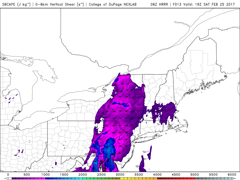
The 6z HRRR model valid for 2pm shows some decent surface-based CAPE and deep-layered wind shear, which supports some severe thunderstorms (NEXLAB).
Sometimes the HRRR model overdoes things a bit, but it does still show decent surface-based CAPE values generally between 500 and 1200 J/KG — which is below typical severe weather thresholds — but is enough given the other impressive dynamics for some severe weather. Also notice the wind barbs — they represent the deep-layer wind shear. There is plenty of wind shear which will help with thunderstorm organization. This is also a byproduct of the very strong mid-level winds with a system as dynamic as this one, as well as the strong low-level jet, so strong wind gusts can readily transfer down to the surface with convection.
Notice, though, how there is no surface-based CAPE along the coast — this is because the onshore flow provides a stable marine layer, so there is no surface-based instability. Thus, the low-level directional wind shear is irrelevant along the coast, since there is no instability for this wind shear to tap into. However, further inland into E PA and W NJ, there is no stable marine layer, so the surface is warmer and more unstable. This means that the southeast low-level winds providing directional wind shear is very relevant, since now the rotation from southeast winds at the surface to southwest winds aloft, as well as the rapid increase in velocity to those winds aloft actually does tap into plenty of instability. This juxtaposition means that updrafts will be a bit more intense and will be rotating in these areas, so some supercell structures producing isolated severe hail is possible as well as even some tornadoes. Along the coast, tornadoes will be very hard to come by, because the stable surface will kill off any rotating updrafts.
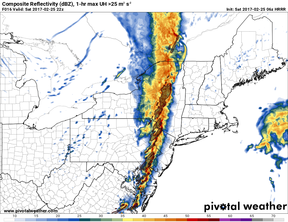
The 6z HRRR valid for 5:00pm shows updraft helicity values in excess of 25m^2s^2 embedded in a strong line of thunderstorms. This supports severe wind gusts as well as enough rotation for a few tornadoes, as well as some isolated hail (Pivotal Weather).
Because of the above reasons, the updraft helicity will weaken as these storms hit the coast, so more widespread severe weather is less likely east of I-95. But because the low-level jet will increase along the coast and thus increasing moisture convergence, the line itself should still be able to mostly hold its intensity — or at least maintain most of its strong winds even if the storms themselves weaken — all the way into NYC and parts of Long Island — the forcing compensates for the lack of instability. And with 45 to 55 knot winds just above the surface, even coastal areas could see some isolated wind gusts between 50-60mph — borderline severe levels. The soundings are not classic for hail, but the mid-level temperatures are still cold enough for some pea-sized hail. Those severe wind gusts will be more widespread further west.
So the general timeline looks to be a line of thunderstorms forming in Central PA between 1:00 and 2:00pm, and strengthening as it heads to Eastern PA at around 4:00pm. A few discrete supercells may form ahead of this line that could produce some isolated tornadoes and pea to 1″ hail. This line will overtake the discrete cells pretty quickly and then head into Western NJ at around 5:00pm, having already produced a decent amount of severe wind (55+mph gusts) in Eastern PA with bow echoes. They will still pack a good punch in Western NJ but be slightly weaker than they were in PA, with less hail and a much smaller chance of a tornado, though an isolated one is still possible. From 6:00pm through 7:00pm, this line will cross I-95 and then head east into NYC and Long Island — this will generally have 40-50mph gusts with some isolated gusts between 50-60mph, but no tornado threat and just some isolated pea-sized hail. The marine layer will not weaken these storms as quickly as others may be forecasting. There will be lightning with these storms, especially in E PA, but not widespread cloud-to-ground lightning.
This was obviously a very technical post, so if you have any questions about terminology, please do not hesitate to send us an email!