-2")
PM Zone Update: Myriad of hazards in Northeast US on Friday
An active pattern, discussed for several weeks, has finally arrived over the past several days. Its impacts will continue to be felt late this week into parts of the weekend. Despite some drier and more pleasant weather on Wednesday and Thursday, another significant storm system is already organizing over the Central United States. This storm system is currently producing severe weather in the Mississippi River Valley and its moisture will continue to shift towards the Northeast States.
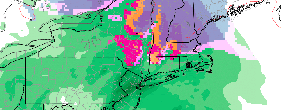
The first sign of its arrival will be increasingly thick clouds which will lower as the evening goes on. Precipitation will then develop northeastwards from the Mid Atlantic and Ohio Valley into the Northeast states from late Thursday Night into Friday. For much of the Mid Atlantic and Coastal Southern New England, precipitation will begin as rain — although some ice pellets are possible as the atmosphere begins to moisten up over Pennsylvania, New York, and New Jersey.
New England
Meanwhile, the atmosphere will remain cooler in New England as a result of a cold high pressure system to the northeast funneling low level cold air in at the surface and in the lower and mid levels of the atmosphere. This will allow precipitation to fall as sleet and snow even in parts of Connecticut on Friday into Saturday as a low pressure system forms off the coast of Long Island. For much of Connecticut and Southern New England, precipitation will eventually change over to a wintry mix and then plain rain.
The wintry concerns, however, continue further north. In Upstate New York, Massachusetts, Vermont, New Hampshire, and Maine, cold air will remain stout throughout the atmospheric column. While some mixing of precipitation types is possible, it appears probable that significant winter weather will occur in these regions. Snow will be heavy at times from Friday into Saturday and significant accumulations are possible in the higher elevations.
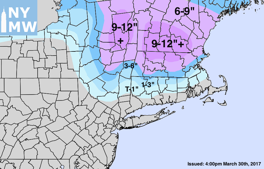
Storm Total Snowfall Forecast through Saturday.
The most noteworthy accumulations are likely to occur in Northeast New York State, Southern and Central Vermont and New Hampshire, into North/Central Massachusetts. Here, the best alignment of cold air and lift (to produce heavy precipitation) exists. A significant late-season snow event appears probable in these regions. The gradient further south from there will be notable as mixing cuts down precipitation amounts, even near the coast and towards Boston.
Snow may linger in these aforementioned regions through Saturday as the low pressure system develops and begins to pull away.
The Mid-Atlantic
While snow and wintry weather will be the focus in New England, very heavy rain and thunder with the potential for flooding will exist in the Mid Atlantic States. A very significant fetch of moisture will develop as the storm system forms on Friday, pushing ample moisture northwards into the Mid Atlantic States. This will lead to the development of steady and heavy rain later on Friday, spreading from Delaware and Maryland into Pennsylvania, New Jersey and New York.
Most notably, a strong low level jet will develop later on Friday Night. Low level jets are areas of enhanced winds in the lower levels of the atmosphere. These act to enhance lift and precipitation and can sometimes produce very gusty winds. Friday evenings low level jet (LLJ) will be no different. Forecast models suggest the development of very heavy, convective rain throughout the mentioned regions.
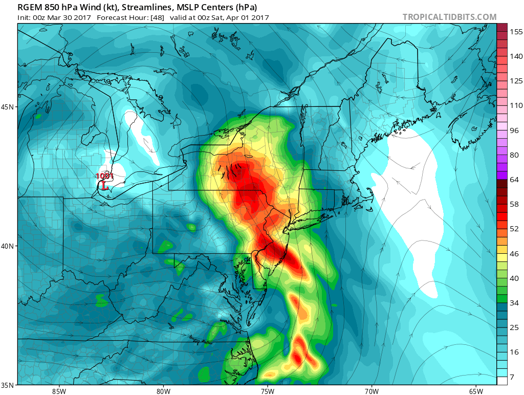
Forecast models show a strong low level jet stream on Friday which will lead to heavy rain in the Mid Atlantic.
With wet ground and recently active pattern, flash flood guidance is quite low. Most areas are “at risk” for flooding after 0.5 to 0.75″ of rainfall based on current conditions. Therefore, the potential exists for flooding with the areas of very heavy rain expected to move through these regions on Friday and Saturday morning. Be sure to remain weather-aware, especially if you live in a typically flood prone region.
Wrapping it up
The storm system will begin to exit the Northeast States later on Saturday as a low pressure system moves to the northeast from a position South of Long Island off the coast of New England. Precipitation may linger throughout the Northeast at first on Saturday, before drier air begins to move in and clears things out.
Stay tuned over the next 12 to 24 hours as we begin to analyze the newest available data. We’ll have the latest information and updates as we move forward through the overnight and with our early AM Zone Update!