-2")
3/31 All Zones AM Update: Heavy Rain Likely By Tonight, More Wintry Mix Possible Well North
Periods of rain overnight and this morning, have been associated been mid-level warm-air advection and frontogenesis, well ahead of surface and closed mid-level low over the Ohio Valley this morning. Some sleet or ice pellets have also been reported. But with temperatures warmer at the surface and aloft, no wintry precipitation of any consequence appears likely for most of the region this morning or afternoon.
The surface low over the Ohio Valley will weaken as it transfers to a secondary low developing over Mid-Atlantic coast by tonight. A warm front and strengthening southerly low-level jet between this these two lows will cause rain to become steadier and heavier over most of the region by this afternoon. High temperatures will range from mid-upper 30s to lower 40s north over northern Interior zones to mid-upper 40s to lower 50s over southern and coastal zones.
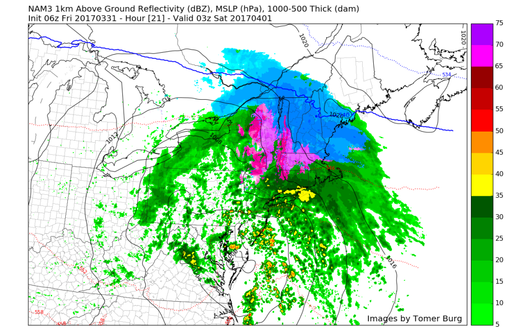
Then rain will continue heavy at times for much of tonight, as the secondary surface low deepens underneath closed mid-level low, which be tracking just south of Long Island tonight. The low-level jet will cause a firehouse of Atlantic and subtropical moisture will be streaming into the region. Increasing mid-level frontogenesis and moisture convergence will lead stronger forcing (lift) for period of very heavy rainfall, for parts of the region during tonight.
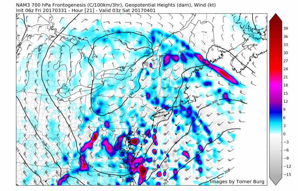
High-resolution NAM model showing strong 700mb frontogenesis moving through parts the region tonight, resulting in more forcing for very heavy rainfall.
As noted yesterday, precipitable water values will again be between 2 and 3 standard deviations above normal. This will support some flooding from heavy rainfall in poor drainage and low-lying areas. Models suggest some elevated instability may also lead some embed thunderstorms with torrential downpours, especially south and east of NYC.
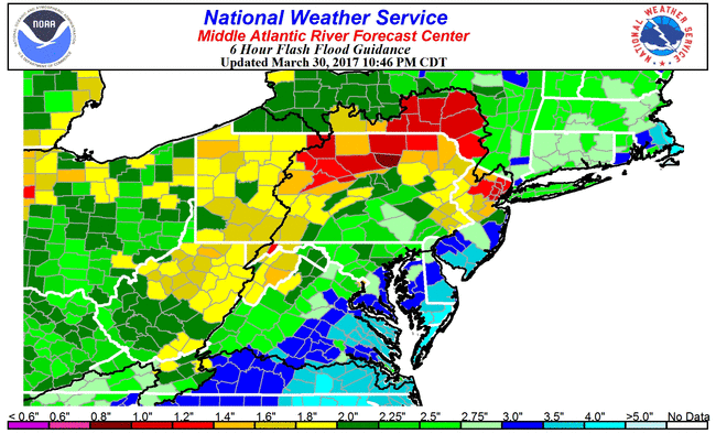
Currently model and ensemble guidance suggest rainfall totals between 1” to 2” over much of the region, by time this tapers off Saturday morning. Some locally heavier totals up to 3 inches or more are possible, especially under more convection or training heavy downpours. Based on flash flood guidance, this could lead also some flooding around small rivers and streams. Especially over Western NJ and Eastern PA, where the Flood Watches have been issued, starting from this afternoon and continuing through late tonight.
Onshore winds also be increasing by tonight, as the strong low-level jet moves ahead. A stout inversion will likely more damaging winds aloft from reach the surface. But these winds will also gust to between 40 to 50mph along the coast. This could result in some widespread minor to locally moderate coastal flooding during high tides early tonight, especially along Long Island south shore and back bays and New Jersey shores.
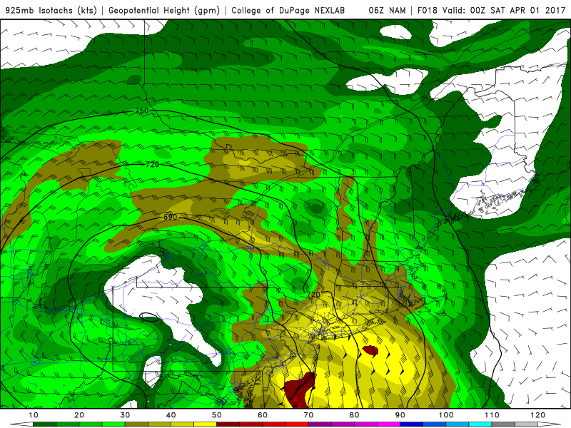
NAM model with strengthening low-level jet with 925mb winds increasing to 50kts+ over coastal sections
As low pressure continues deepen and track offshore winds more northerly later tonight and Saturday morning. This will begin to usher cold air back into region with possibly rain changing to wintry mix of sleet or freezing rain over far northern interior areas late tonight and Saturday morning. But mid-level dry air will cause precipitation begin to tapering off and ending on Saturday morning over much local region. So currently no significant impacts from wintry precipitation are still anticipated even for northern sections of our zones. However, further north over Upstate New York and into Central and Northern New England more significant snowfall is possible. Another zone forecast update may sent out this afternoon more focused on the wintry aspect of this storm for the far northern interior areas.
The weather will gradually improve over this weekend, as the storm system departs the region. Some clouds and rain could linger into Saturday, before clearing more late in the day or during the evening hours. High temperatures will likely be int mid-upper 40s, with more cloud cover into the afternoon. Sunday will be more pleasant, with drier downsloping northwest winds leading to more sunshine and warmer temperatures in the mid-upper 50s.
Dry and seasonable cool weather is still anticipated during the day on Monday. Then the next storm system arrives with more rainfall on Monday night and Tuesday. An active pattern will continue with more disturbances bringing rainfall over the next couple weeks. Stay tuned for more zone forecast updates this afternoon or evening on this current storm system and weather conditions through into next week!