-2")
Evening All Zones Update: Heavy Rain and Flash Flooding Thursday
After nice Spring weather made an appearance on Wednesday, things are about to quickly go downhill during the overnight and into Thursday. A very expansive and classically synoptically deepening storm system will trek its way towards our area. With it, a few rounds of heavy rain, rumbles of thunder, and flash flooding are likely.
The storm will cut itself off from the atmosphere at the mid-levels, which allows synoptic features for ascent to remain in-place for a longer period of time. Thus, unlike Tuesday where it was one quick wave of heavy rain with the warm front and then only isolated to scattered showers and thunderstorms behind it, this storm should feature multiple waves of heavy bands of rain that last a decently long time.
Similar to Tuesday, however, is the evolution of a warm front out ahead of a system pushing our way and tapping into a low-level jet for lift and moisture. This is how the first batch of rain will move into the area during the late-overnight and early-morning hours.
Generally, though, this first batch of rain will not be all that heavy as it will out-run the best synoptic forcing to the south, but some embedded quick heavy pockets of rain are possible in the 5:00am through 9:00am timeframe.
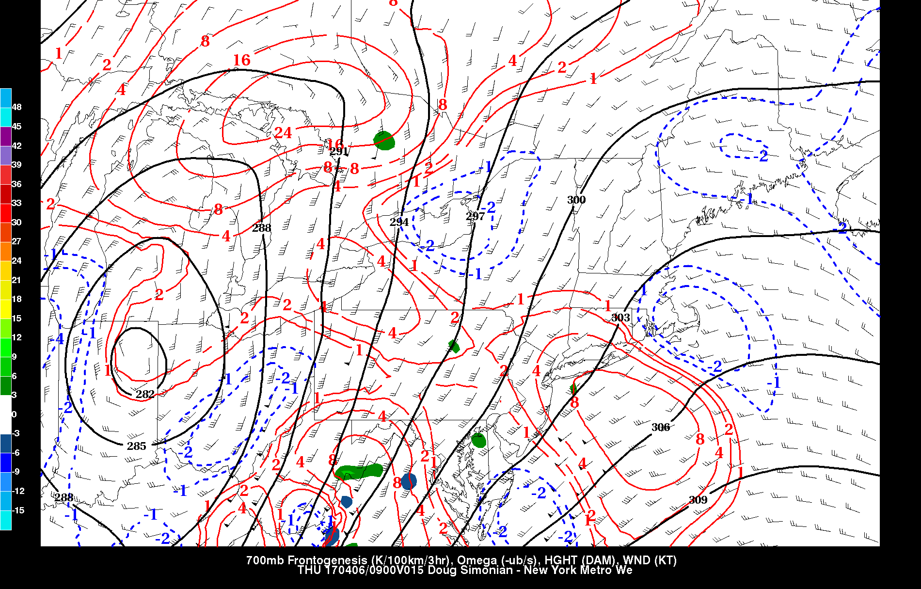
This afternoon’s NAM model valid for 5:00am Tuesday morning shows some frontogenesis running out ahead of the main storm, resulting in rain breaking out.
The above image shows the 700mb frontogenesis running out ahead of the main area of lift to the south, and into our area — this is associated with the warm front and isentropic lift. Anywhere from around 0.2″ to 0.5″ of rain may fall with this batch.
There may be a bit of a lull for a 1-3 hours before the main batch of rain moves through during the late-morning and early-afternoon. Precipitable water values at this point may be surging up to 1.4″, which is plenty of moisture for heavy downpours. A very high amount of differential vorticity advection will be had in the Mid-Atlantic at the base of the 500mb low, which will pinwheel heavy bouts of precipitation northward into our area. Additionally, the low-level jet will actually be increasing in strength, propelling additional moisture into the area from the Atlantic. When combined with the warm front stalling out pretty close to our area, we will be under the gun for plenty of heavy rain.
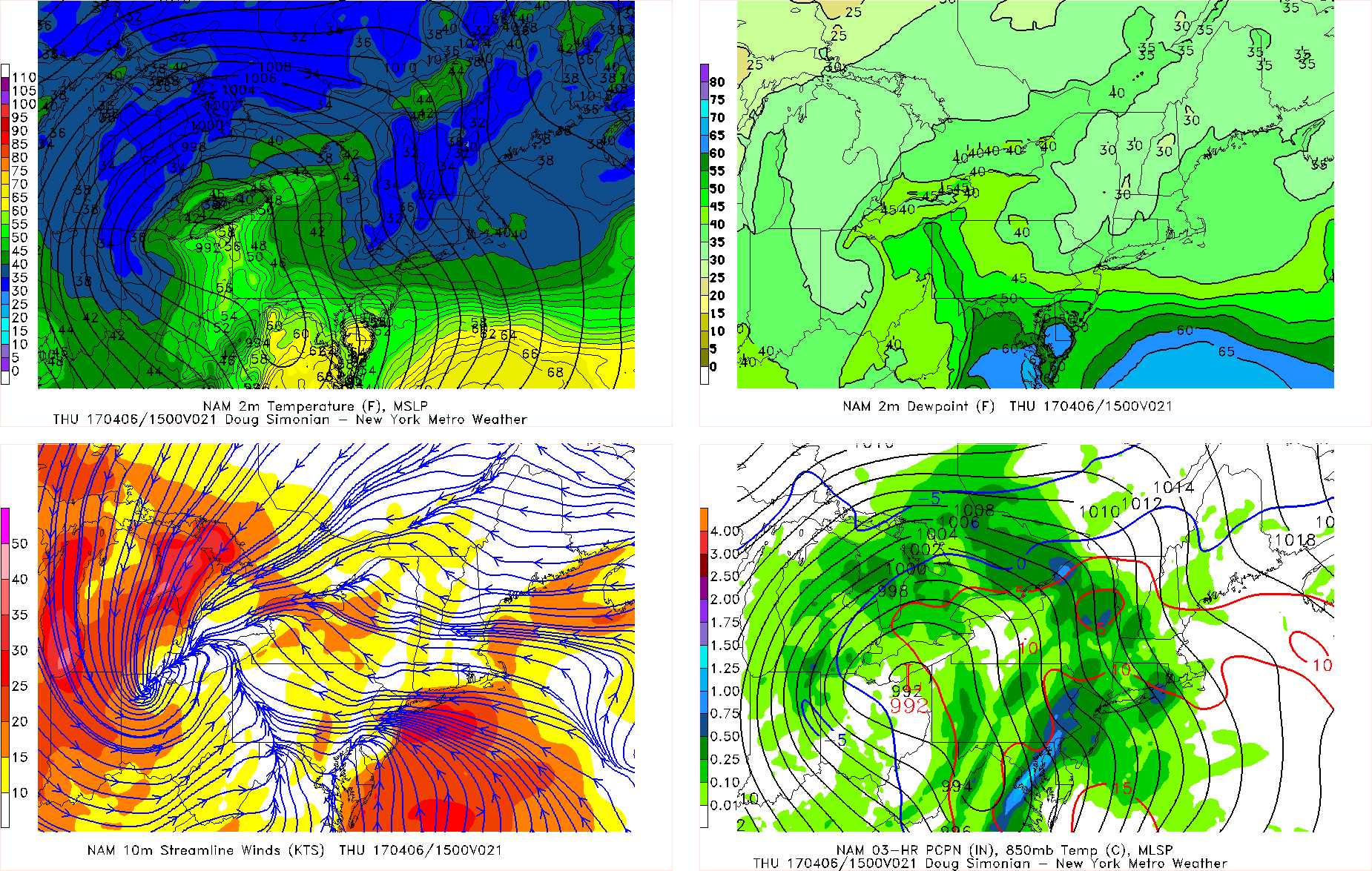
This afternoon’s NAM model valid for 11:00am Tuesday morning shows a firehose LLJ from the Atlantic and into the area, leading to moisture transport and some low-level convergence for plenty of heavy rain.
Sometimes, low-level jets run from due south to north along the coast, which can still propel plenty of moisture, but this low-level jet actually curls back cyclonically from SE to NW, from the Atlantic and directly onto land. This is a better source of lift and moisture than the former because it has a more direct Atlantic component. This leads to more moisture and also less friction, thus it can generally go faster over water. But then when it hits the land, it slows down due to friction, but that decelerating of the jet is actually another way to generate convergence, and thus lift — it doesn’t have to be two parcels of air directly colliding into each other. The storm cutting off in the middle of the atmosphere allows for more curvature to the height field in our area, and thus this orientation of the LLJ. This LLJ may also be strong enough to lead to wind gusts along coastal areas to exceed 40mph as well as lead to coastal flooding.
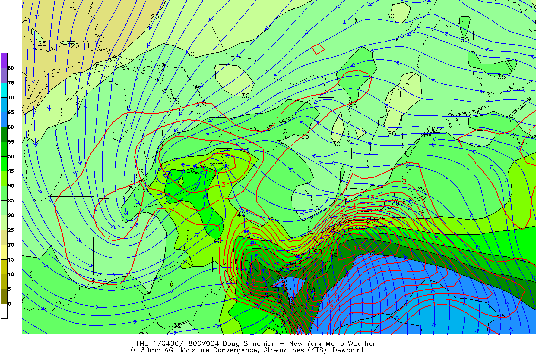
This afternoon’s NAM model valid for 2:00pm on Tuesday shows extremely high moisture convergence, further supporting heavy rain.
Another way to illustrate this is via moisture convergence, which is a better indicator of moist air parcels in the low-levels converging rather than just any air parcels. Moist air is more buoyant than dry air, and thus the value of this tool. This is a direct result of the LLJ pinwheeling from the Atlantic and onshore, rather than just going from due south to north. This will help to reinforce and strengthen bands of heavy rain, and also lead to some training of the rain, too. Thus, some localized areas will get hit over and over again by heavy rain and could see localized 3″ amounts.
Other tools we have been using are Q-Vector Convergence, and differential vorticity advection — these are diagnostics of the forcing aloft for upward vertical motion.
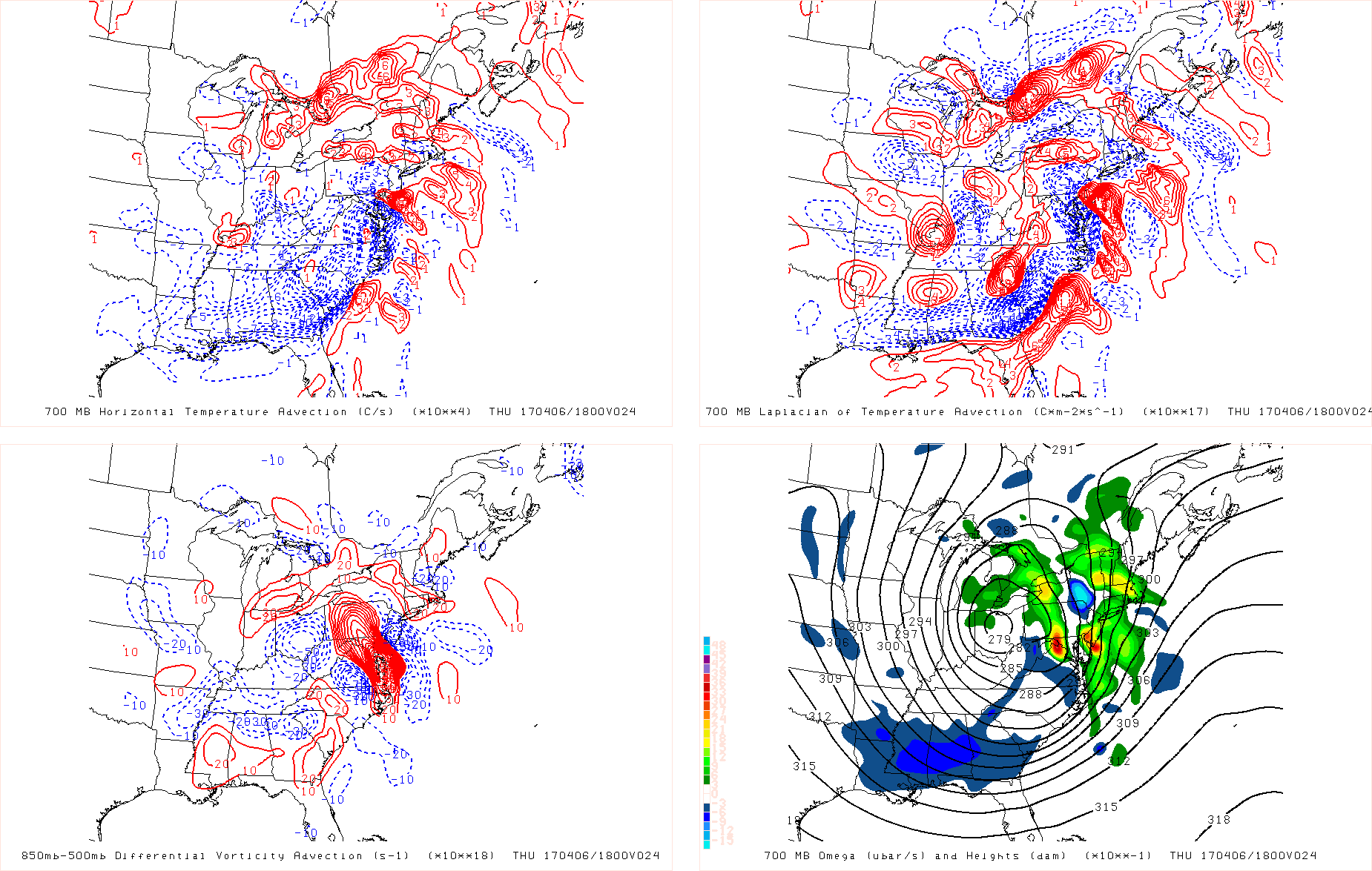
These four panels are other synoptic ways to diagnose lift. The bottom left shows very high differential vorticity advection in the Mid-Atlantic, generating a lot of lift there.
The above 4-panel plot is from this afternoon’s NAM and is valid for 2:00pm on Tuesday. The area to focus on here is the Northern Mid-Atlantic and Southern New Jersey. The bottom left shows differential vorticity advection — when you have more vorticity advection aloft than at a lower level, that leads to upward vertical motion. In that plot, it’s showing that we have a lot more 500mb vorticity advection than 850mb vorticity advection in the Northern Mid-Atlantic, and thus plenty of forcing for upward vertical motion. This extends up through SE PA and Southern New Jersey. The top right panel shows the local maximums and minimums in the warm air advection at 700mb — the local maxes are where lift is often focused. Look at the maxes in Southern New Jersey and SE PA. This is why the 700mb omega is high in those locations (bottom right) and should thus be a genesis of heavy rain bands that move into our area.
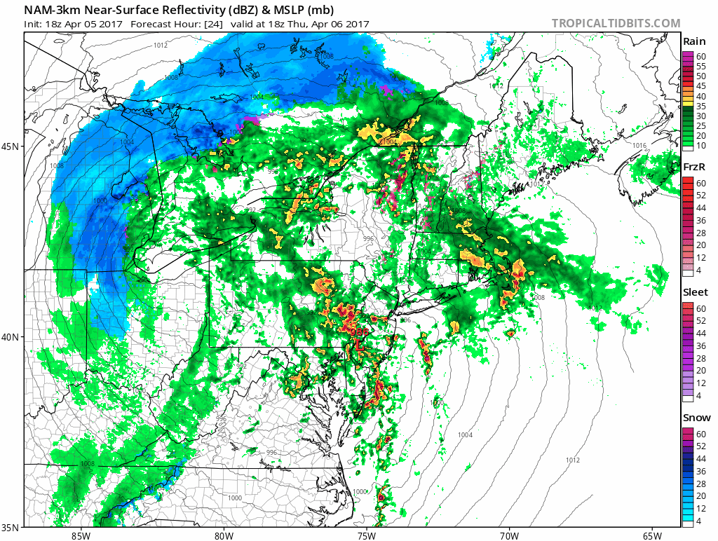
Today’s NAM model valid from 2:00pm through 4:00pm shows heavy rain moving in from SE PA and S NJ into our area — conforming the vertical motion diagnostics. (Tropical Tidbits).
Sometimes the NAM model is a bit too slow, so perhaps this comes in a tad earlier — but either way the idea of a very heavy band of rain in the late-morning and/or early-afternoon is very much possible. This simulated radar confirms the vertical motion diagnostics.
Let’s take a look at the Q-Vector convergence.in the 700mb t0 400mb layer (middle of the atmosphere approximation).
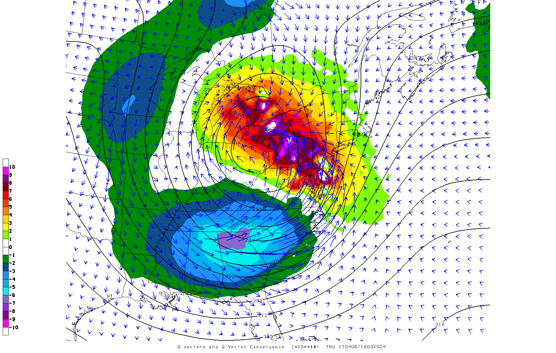
This afternoon’s NAM model valid for 2:00pm shows plenty of Q-Vector convergence in and near the area, showing plenty of forcing for upward vertical motion.
In this image, while most of the Q-Vector convergence is well to the west, we do have a decent amount of Q-Vector convergence in our area, favoring ascent. It makes sense — well to the west, we expect a long, stalled out snow band (see the radar gif), which is more of a pure “synoptic” band of precip from a deepening low pressure that is very friendly to this kind of diagnostic. Plus, this band is generally expected to stall in that area. There’s also plenty of Q-Vector convergence to the southwest, within some of the strong differential vorticity advection and warm air advection maximum. This thus further shows how precipitation will generate via lift to our south and southwest, but then as it moves northeast into our area, will expand and get enhanced due to the low-level jet/moisture convergence and the warm front — an overall classic setup for heavy rain. Plus, the low-level jet and moisture convergence may generate some rain on its own as well.
We thus expect two to three rounds of rain with this storm. The first in the early through mid-morning from the warm front and frontogenesis running out ahead, the 2nd from the strengthening LLJ and moisture convergence triggering its own showers near us in the late-morning, and the third from all of the ingredients (Q-Vector convergence, differential vorticity advection, maximum in the warm air advection, high precipitable water, the LLJ, moisture convergence, etc) coming together to generate the heaviest rain of all in the early-through mid-afternoon. The 2nd and third rounds may end up combining. There may be enough elevated instability with this for thunder as well. Overall, we expect a general 1.5 to 2″ of rain, with local amounts close to 3″ in the training bands of rain. Activity will become more showery in the evening.