-2")
PM All Zones Update: Warmth Continues into Early Next Week
Good afternoon, everyone! We hope you are enjoying this lovely Sunday afternoon. Yesterday had more of a crisp, autumnal feel, while today truly feels like Spring with temperatures well into the 60s and even some low 70s in the warm spots. This is because Canadian High pressure that had settled into the region yesterday has now slid offshore, resulting in more southerly return flow and warming mid-level temperatures. A large mid-level ridge over the region has also provided quite a bit of stability in the atmosphere, which puts a nice cap in the atmosphere, and thus shunted vertical motion, which leads to sunny skies.
The one reason why it’s not even warmer today is because while the flow in the low-levels is southwesterly, the flow in the mid-levels has not yet turned that direction because the upper-level low from Friday has not completely moved away from the NW Atlantic yet. However, come Monday, the ridging will have a more classic orientation from SW to NE, which will lead to more of a true Southwest flow in the entire atmospheric column. Thus, temperatures will get even warmer.
An animated gif of today’s 12z NAM analysis: the first is from Sunday at 2pm, the next is a forecast for Monday at 2pm. Notice the differences!
This animated gif illustrates these points well. This is a 4-panel plot of the NAM: top left is 1000-500mb thicknesses, precipitation, and surface wind barbs, the top right is 850mb heights, winds, and temperatures, the bottom left is 500mb height, winds, and vorticity, and the bottom right is 300mb heights and winds. The first image is valid for Sunday at 2pm, the next is valid for Monday at 2pm. Notice how for today at 2pm, there are still some remnants of the upper-level low in the picture, creating a kink in the heights, and thus more northerly flow aloft: look at how chilly the 850mb temperatures still are. But on Monday, the ULL will move out of the way, allowing for higher heights and much more southwest flow aloft — look how much warmer the 850mb temperatures are. Because of this, and still a good deal of ridging, we expect plenty of sunshine on Monday with temperatures well into the 70s — perhaps even 80 in the warm spots.
More of the same is expected on Tuesday, with even warmer temperatures. A mid-level disturbance in SE Canada will help to increase the height gradient downstream, and thus accelerate our southwest flow further, leading to even warmer mid-level temperatures. This will translate to widespread highs in the upper 70s to low 80s for the whole region.
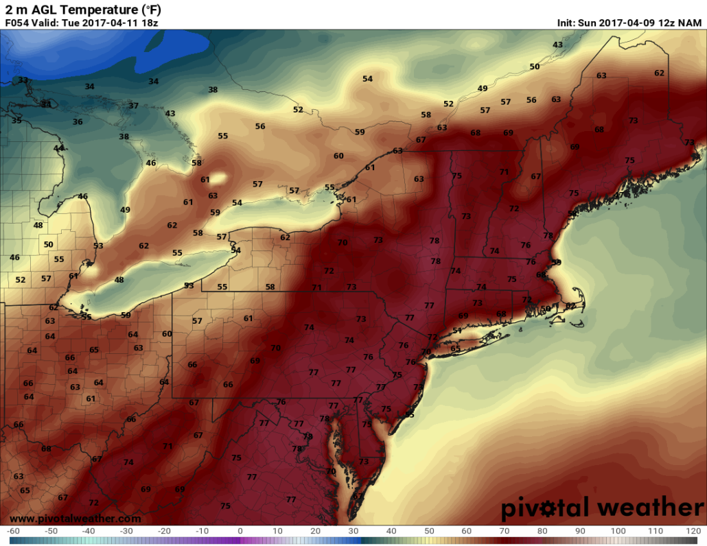
Today’s NAM valid for Tuesday afternoon shows temperatures well into the 70s. But notice the seabreeze causing much cooler temperatures right along the immediate coast.
The caveat to some of the warmth on Monday and Tuesday will be the sea-breeze. Ocean temperatures this time of year are still quite chilly, so that temperature difference between land and sea helps to accelerate the sea-breeze, especially when regular surface winds already have some southerly component right off the water. Plus, the cold water itself provides a chillier low-level airmass this time of year than it does later in the year when the waters warm. Thus, temperatures right along the coast will probably hold in the upper 60s to around 70 for highs, with temperatures quickly falling cooler than that in the mid-afternoon hours as the sea-breeze accelerates.
The next chance of rain is from a weak cold front moving through the area on Wednesday. The forcing with it is not that impressive, but the initial warm airmass may provide enough thermodynamic lift to help yield some showers.
Today’s GFS model valid for Wednesday afternoon shows decent forcing for lift, and thus some showers.
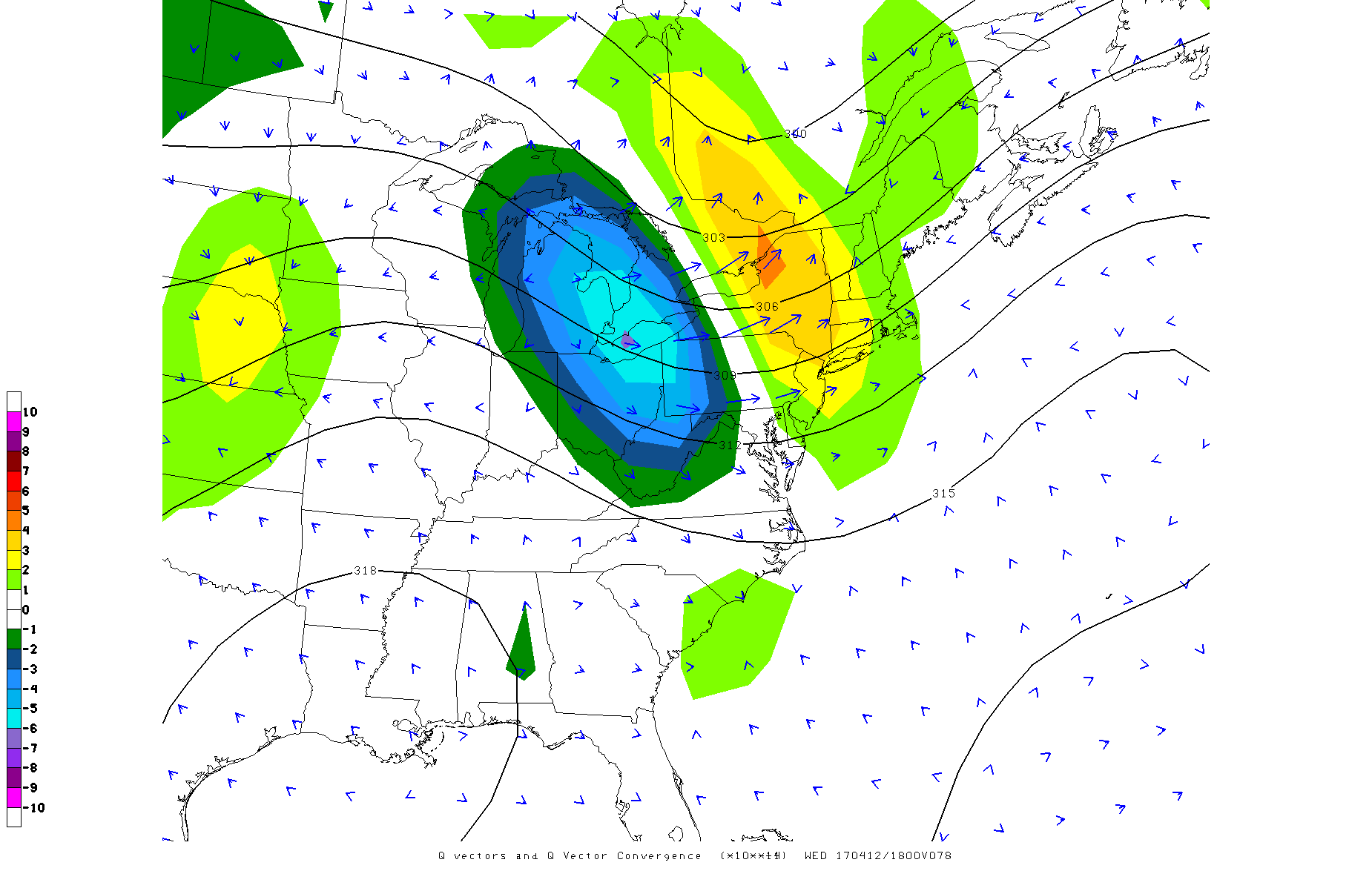
The above is a new plot we debuted for Thursday’s heavy rain: Q-Vector Convergence in the 400mb to 700mb layer. It’s a good indicator of the synoptic forcing for lift in the atmosphere, and is thus a good barometer as to where we can expect some precipitation to develop. The above shows decent Q-Vector Convergence associated with the weak front on Wednesday afternoon, and thus some showers are likely — though the best forcing for lift will stay to our north. Thus, we do not expect heavy rain on Wednesday — that should stay in Central and Southern New England. You can even see some of the blue arrows converging with each other in that region, as well as fast, large blue arrows slowing down — deceleration is also a form of convergence. Temperatures will generally cool off into the 60s with this cold front. Another weak front on Thursday may cool temperatures further — into the upper 50s to low 60s for highs late next week into next weekend with more clouds around and perhaps some showers as well.