-2")
Public Analysis: Brief Cooldown, Followed By More Warm and Unstable Weather
Good Afternoon!
After temperatures in the mid to upper 80’s yesterday across much of the region, a weak cold front and some weak showers will bring temperatures back down to more seasonable levels starting this evening and lasting through Saturday. However, by Easter Sunday we may see a return to much above-normal temperatures with a chance of showers and thunderstorms.
This Afternoon and Evening
The weak upper level system that we talked about back on Monday has moved through the NYC metro area this afternoon and has brought some light to moderate showers, with even a few very isolated rumbles of thunder. As of 2pm, this activity was heading east at a pretty decent speed while it also outruns the best upper-level support to sustain these showers. This area currently situated over Long Island and Connecticut should continue to progressively move east this afternoon and eventually move offshore while continuing to weaken in the process.
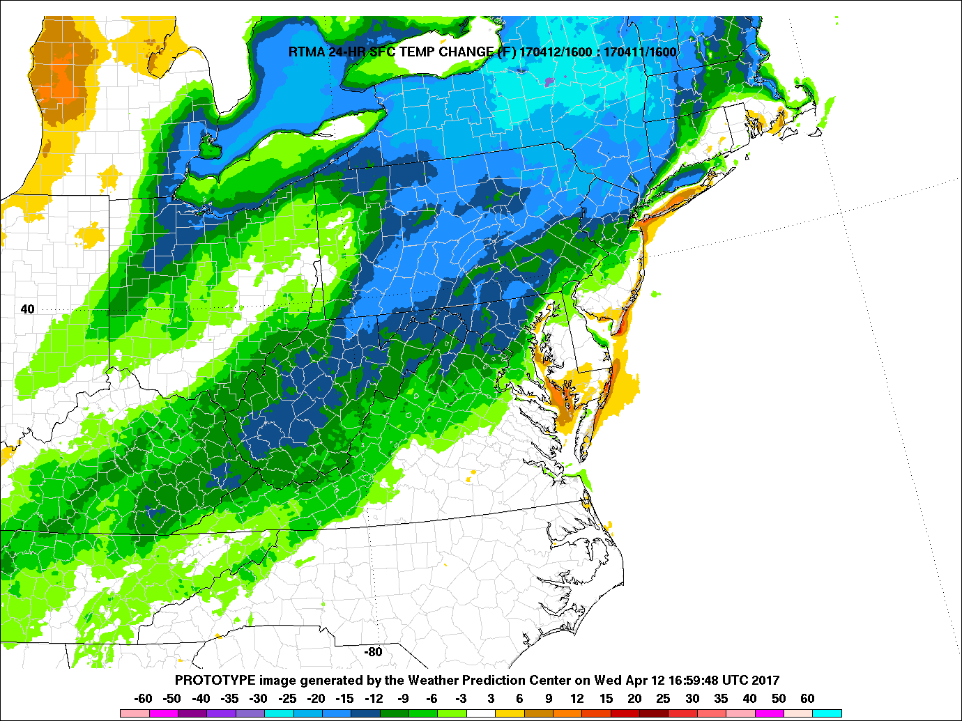
Rapid clearing is taking place behind this area of showers, as dry air begins to settle in from the north and west. As skies continue to clear this afternoon, temperatures should be able to rise into the upper 60’s and lower 70’s across the area, with coastal locations staying on the cooler side once again. Even with temperatures currently in the mid 60’s and lower 70’s across the area, this is still a good 10-20 degrees below what temperatures were just 24 hours ago.
As was mentioned back on Monday, the actual cooler air with this front is lagging behind the shower activity by quite a bit, but as high pressure begins to drop down from Canada late this evening, temperatures should be able to fall into the 40’s across the entire area, with an outside chance of upper 30’s across the interior sections of NY.
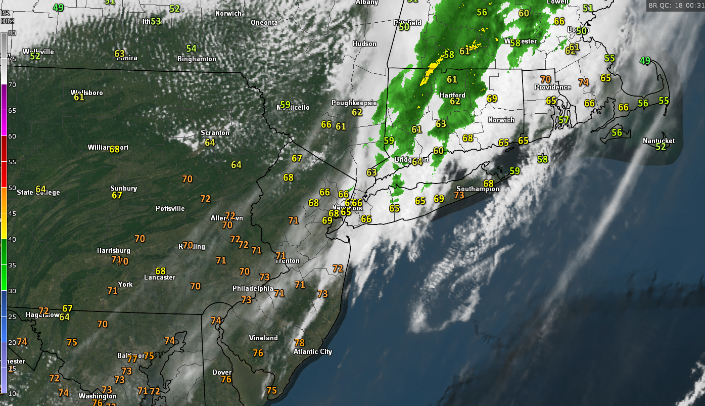
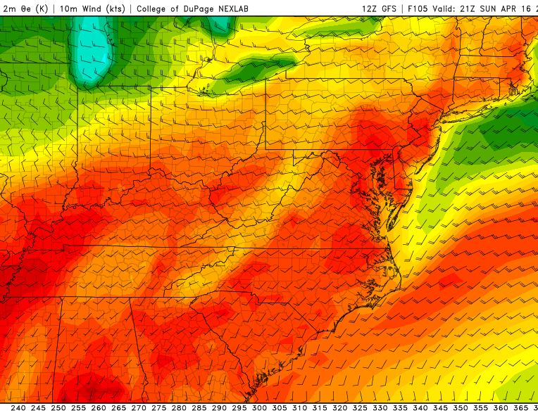
Current surface temperatures, regional radar mosaic, and visible satellite imagery showing rather rapid clearing taking place behind the weak upper-level disturbance (Courtesy of GREarth)
Thursday and Friday
High pressure will be in control in time for the morning commute tomorrow, with relatively cool temperatures likely by 8am, ranging from the mid to upper 40’s across the area. Some overcast and broken clouds are possible tomorrow morning and into early afternoon, before a brief break giving way to mostly clear conditions. This should allow temperatures to easily rise into the upper 50’s and low to mid 60’s across the area by late tomorrow afternoon.
Another weak cold front will be set to move through tomorrow afternoon and evening, bringing some more broken clouds and winds of about 10-15 mph sustained out of the northwest. The lack of moisture and lift associated with this front will forbid the development of showers, so only increased cloudiness is expected into tomorrow evening.
The lack of clouds and light to moderate winds underneath the area of high pressure will allow temperatures to fall into the low to middle 40’s tomorrow evening, with inland sections of northern New Jersey and New York possibly slipping back down into the 30’s for lows.
Friday should be a relatively tranquil day as the area of high pressure continues to remain in control over our area. Mostly sunny conditions are expected with a few clouds possible over the south and west portions of the area. Calm winds and clear skies should give way to seasonable temperatures Friday afternoon, with highs ranging from the upper 50’s to mid 60’s across the entire area. As we head into the evening, the same calm conditions will allow for temperatures to slip into the 40’s for lows once again, with 30’s possible in the interior sections.
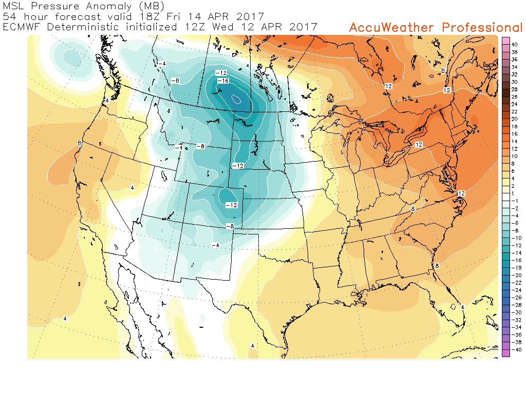
12z European model showing the area of high pressure centered over the Northeast on Friday afternoon. (Courtesy of Accuweather Pro)
Saturday and Beyond
The area of high pressure that will have been in control for Thursday and Friday will finally move offshore to the Mid Atlantic coast on Saturday, and this will begin to bring quite a few changes for this holiday weekend. As the area of high pressure begins to shift off to our east, winds will change from the north and west, to more southerly/southwesterly during the morning and afternoon hours. This change to more southerly winds will allow warmer air to work its way in during the day, with a warm front progged to move through by 2pm or so.
This warm front will bring an increase in clouds, with a chance at some showers and even some weak thunderstorms during the late afternoon hours. Instability will be quite weak and there really shouldn’t be change from that thinking so at this time it does not seem like these showers and possible thunderstorms will capable of anything outside of some heavy downpours and very isolated gusty winds. Otherwise, temperatures should be able to reach the mid to upper 60’s across the area on Saturday, with coastal locations possibly seeing more prolonged cloudiness which may lead to highs only in the upper 50’s to low 60’s.
As we move into Easter Sunday, much above-normal temperatures seem quite likely as the aforementioned high pressure system located off the east coast continues to funnel warm and moist air from the south and into our area. Some dry/sinking air behind the warm front that passed through on Saturday may allow for a break in the clouds in the early afternoon on Sunday, and this should usher in a mix of sun and clouds to start off the day.
Strong southwesterly winds in the lower levels of the atmosphere will continue to bring in very warm temperatures across the area during the heart of the day, which could allow for temperatures to reach into the low to mid 80’s for locations that see more sunshine and are further away from the coast. Regardless, temperatures will be very warm on East Sunday with the entire area likely experiencing highs in the upper 70’s to mid 80’s, with the exception of coastal locations who may have to deal with a seabreeze later on in the afternoon which could knock temperatures down quite a bit.
As a cold front begins to work its way in towards area of Upstate New York later in the afternoon and evening some more showers and thunderstorms will be possible, but at this time the main focus of this activity should be off to our north and west as the best forcing for storms looks to be displaced from our area.
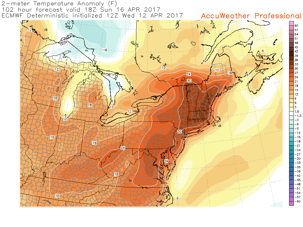
12z European model showing temperature anomalies ranging from 20-30 degrees above normal on Sunday afternoon with temperatures possibly reaching into the 80’s once again (Courtesy of Accuweather Pro)
With the Holiday Weekend coming closer and the threat for some shower and thunderstorms on Easter, make sure to check back for further updates!
For more information and posts like this one, make sure you sign up for Zone Forecasts — where multiple detailed articles, videos, and interactives are posted each day. Also, come interact with our staff and many other weather enthusiasts at 33andrain.com!
Have a great day!
Steve Copertino