-2")
Evening Zones Update: Still Watching the Cut-off Low
Good evening! We are in the midst of more cool, cloudy, and raw weather as yet another warm front got hung up to our southwest, keeping us in persistent onshore flow and thus a marine layer. A few thunderstorms developed in SE PA — an area that is south of the warm front and thus the warm sector — but the warm front’s NW to SE orientation is even keeping most of S NJ in the cool sector, so these storms should weaken as they head into SE NJ. A brief period of heavy rain and a rumble of thunder cannot be ruled out, but we are not expecting anything too hazardous. Further north, no storms were able to develop at our latitude due to the stable low-level airmass and also losing the isentropic lift from the overnight and early this morning, since we lost a lot of the warm air advective processes. This was because there is some cold air advection now occurring aloft in areas that were previously warm and giving us warm air advection as a cold front approaches these areas. This helps to weaken the temperature gradient, making warm air advection much tougher to come by. Also, a secondary area of low pressure developed offshore, preventing true high pressure from moving in and further supplies onshore flow. Thus, we still stay cloudy and cool, and potentially foggy as well with temperatures holding in the upper 40s tonight.
Saturday is a tricky forecast. Some shortwave energy and vorticity will be moving into the region from SE Canada and partially phase with a developing storm to our southwest. This, combined with our area being in between two jet streaks may allow for enough lift for some afternoon light rain. These forcings will be competing with downsloping flow trying to work its way in as winds shift northwest behind the surface low, so light rain will not be widespread and most of the day will be dry.
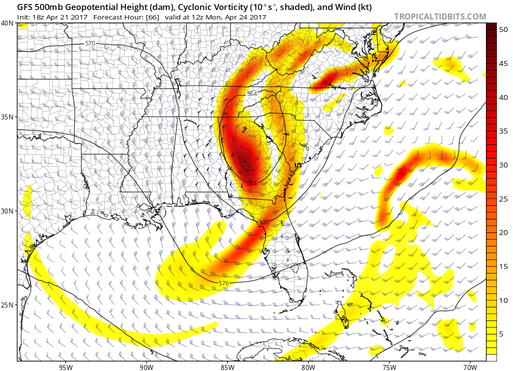
Today’s GFS model valid for Saturday afternoon shows conflicting factors for rain.
The above image shows it well. A shortwave to our northwest that is phasing with shortwave energy to the southwest, a jet streak in New England which places us in the right-entrance region (favorable for lift), but NW downsloping flow at the surface and 850mb. The downsloping flow is more prevalent in northern zones, so it should be drier there with temperatures in the low to mid 60s and partly sunny skies. Southern zones will have a bit less downsloping, so the forcing for light rain may win out in the afternoon, with temperatures in the upper 50s to low 60s.
High pressure will move in on Sunday as that shortwave energy departs and faster, zonal flow aloft will push the developing cut-off low further south, away from the area. This will allow for partly cloudy skies with temperatures in the low to mid 60s.
But evidence has increased that this cut-off low may eventually slowly climb the coast and give us a prolonged period of on and off rain on Monday and Tuesday. On Sunday night, the cut-off low will begin to strengthen and thus be able to pump up the heights downstream. This causes a feedback of even more ridging with an already developing strong West-Atlantic-Ridge (WAR) pattern, creating enough ridging downstream to prevent the storm from going east. Also, the storm will cut itself off enough to completely detach from the incoming trough in the Central US, which also prevents the trough from scooting it east. It thus gets stuck between the WAR and the ridge ahead of the trough in the Central US, which forces it to slowly drift northward. The cut-off low will also develop a negative tilt, which also allows for some north movement.
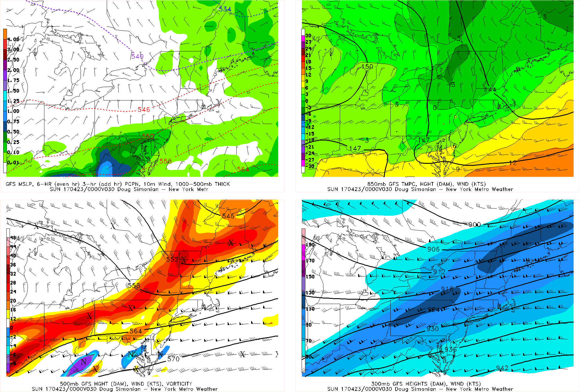
Today’s GFS model valid for Tuesday morning shows a cut-off low slowly drifting towards our area, giving the area some steady rain.
The very slow movement of the storm will mean that for most of its life, it will be pretty far away from the area. But the cut-off low will sit in the Southeast long enough to gather a huge Tropical Caribbean moisture fetch that will move due northward towards the area with wind barbs aloft moving almost due south to north. Thus, some rain will move in well out ahead of the storm and into the area on Monday, though it will be on and off with the main forcing from the storm still to our south. Rain may become heavier Monday night into Tuesday as the storm slowly drifts closer to the area and sends a good area of moisture convergence from the Atlantic and into our area.
Precipitable water values over 1″ and the Caribbean moisture fetch could mean some heavy downpours at times, but still with the main storm well to the south, we will avoid prolonged periods of heavy rain. A persistent deep onshore flow from the Atlantic from a moderately strong low-level jet may also provide coastal flooding and further help the moisture convergence enter coastal regions for heavier rain there as opposed to areas further inland. As of now, we are expecting anywhere between 0.5 and 1.5″ of rain in this period, before the storm occludes on Wednesday and we thus dry out. More ridging will move back into the picture late next week into next weekend with warmer and sunnier weather returning.
For more details on the evolution of the cut-off low, check out the video we uploaded early this morning. You’ll want to skip to around eleven minutes in.