-2")
PM Zones Update: Warmth Returns, but an Active Pattern Soon to Follow
Good afternoon, everyone! Clouds and showers have lingered across the area today as the cutoff low slowly drifts towards our area. Fortunately, the cutoff low is occluding and is thus weakening quickly, which means that the threat of rain will mostly be eradicated from here on in. But this was not before a general 1-2″ of rain fell across the region, including 1.46″ of rain at JFK and 1.25″ of rain in Central Park with some flooding reports in NE NJ.
With the cutoff low in such close proximity, the wind flow in the entire atmosphere has nearly come to a halt, as wind fields surrounding occluding cutoff lows (especially when it’s not winter) tends to be very slow. This slow wind flow combined with the onshore flow that ensues with the storm offshore will lead to low clouds, fog, and mist for the rest of the night as a marine layer remains entrenched. Fog may be somewhat dense in spots, but it may actually meet the dense criteria in E LI and coastal CT (visibilities below 1/4th of a mile). Temperatures will generally fall into the low 50s tonight.
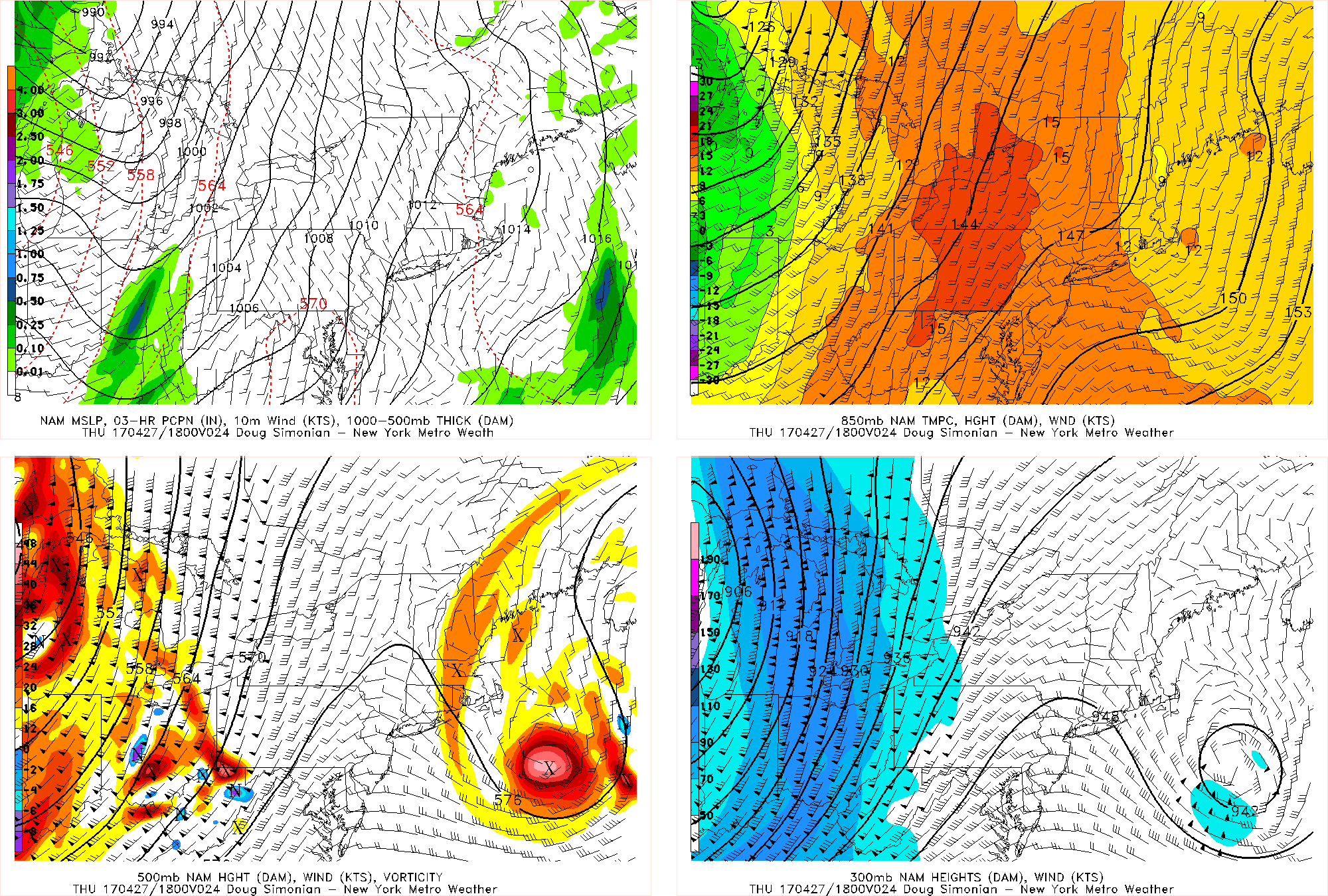
Fortunately, Thursday will start a nice warming trend. As the cutoff low moves away from the region, its influence on the pattern will significantly lessen. Instead, the main influence on our pattern will be a strengthening storm system that will move into the Great Lakes and the associated southerly low-level flow ahead of it as well as westerly flow aloft.
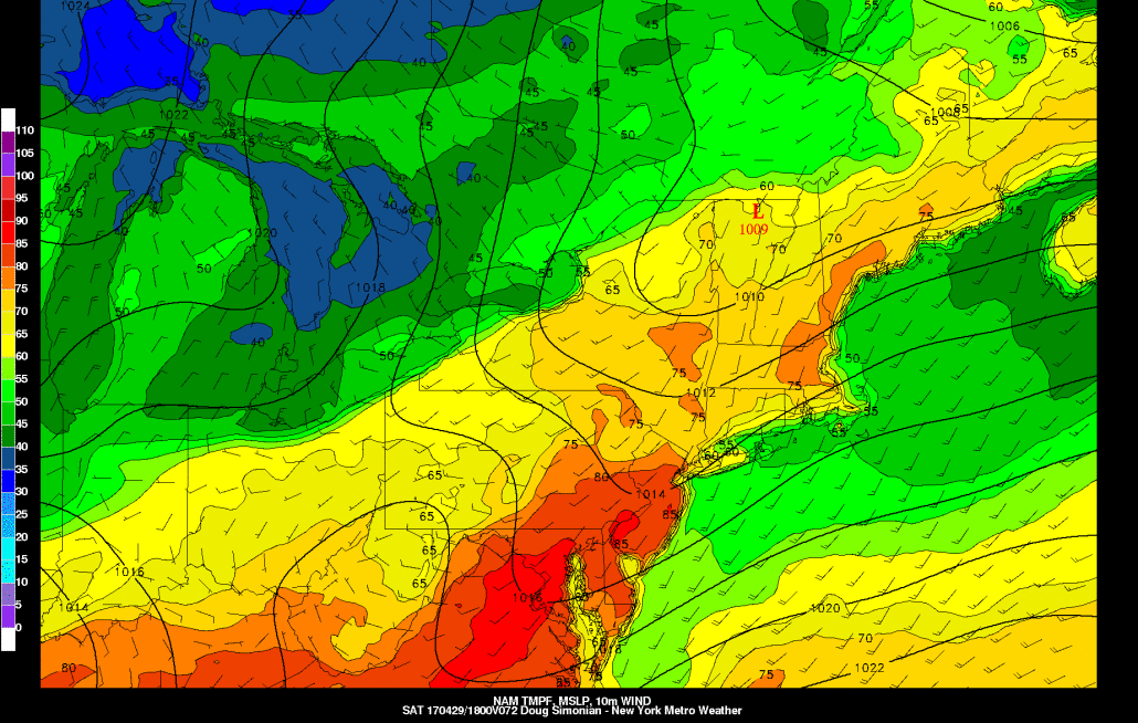
Today’s NAM model valid for Thursday afternoon shows mid and upper-level westerly flow, which will help finally bring some sunshine.
The cutoff low had brought a lot of east to west mid-level flow, too, which led to a relatively saturated column all-around. But with the big ridge out ahead of the storm in the Great Lakes trying to bring southerly flow aloft, but the remnants of the cutoff low still providing enough of a kink to the heights to flatten the ridge at our longitude, this will result in westerly flow aloft. This has a drier component, which should finally help bring sunshine to the area by Thursday afternoon. Combined with the very warm temperatures aloft (look at the 850mb temperatures on the top right panel), we could have easily hit the 70s and 80s. But there is still just enough lingering onshore flow at the immediate surface (check top left panel), as well as still weak wind flow aloft so that the marine layer will not completely be able to escape, and temperatures will thus be held back a bit from their potential since mixing will not be able to occur. Thus, we generally expect high temperatures in the upper 60s to low 70s, with cooler readings along the immediate shores.
As that storm to the west gets closer, a weak cold front out ahead of it may lead to some showers and perhaps a weak thunderstorm on Friday morning with some elevated instability from the aforementioned westerly flow aloft. Once this front clears, we will still be under the presence of that strong ridging as well as much faster wind flow aloft, and low-level flow more southerly and southwesterly as opposed to southerly and southeasterly. This all leads to significant warmth on Friday and especially Saturday.
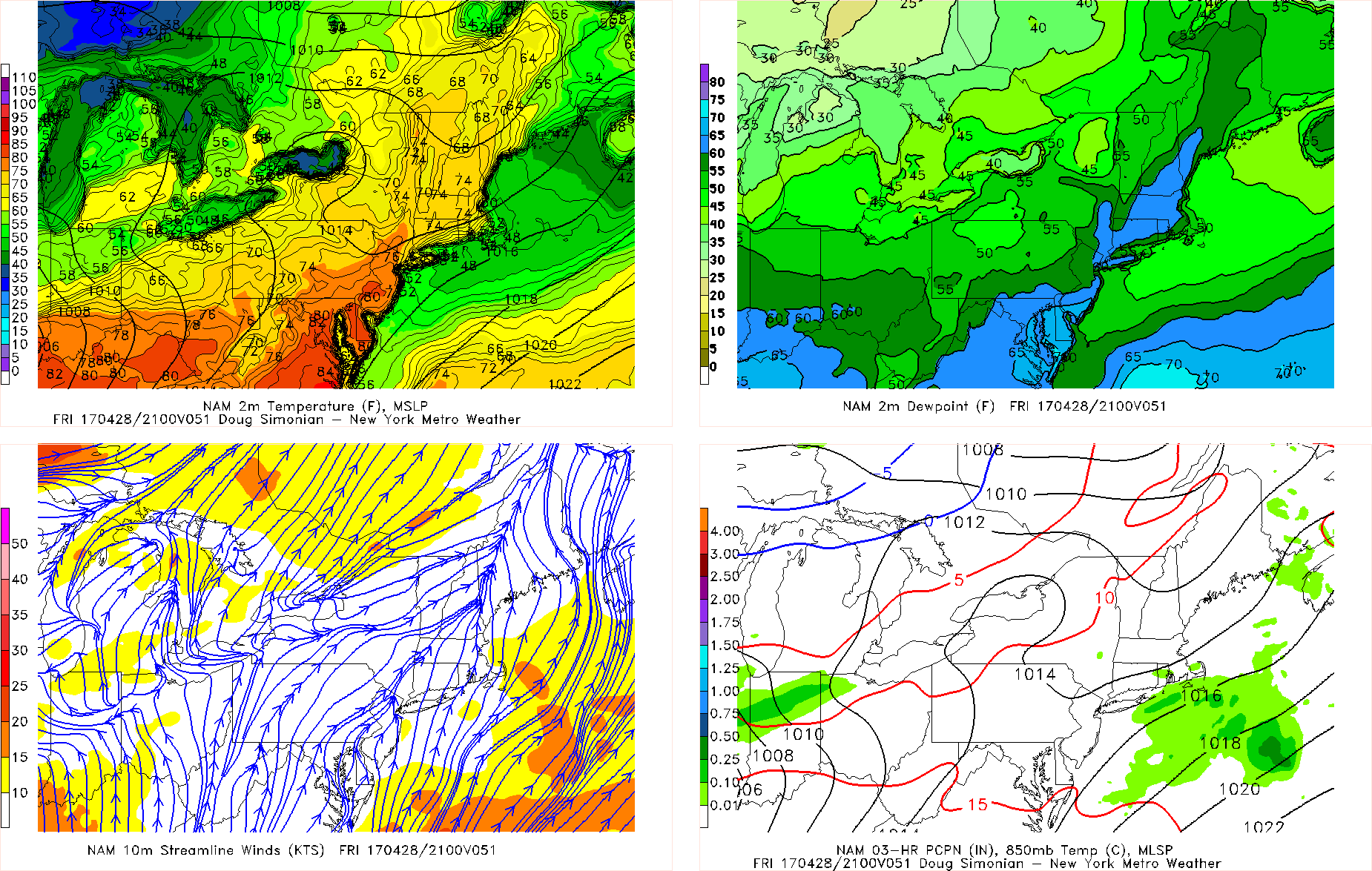
Today’s NAM model valid for Friday afternoon shows temperatures approach 80 degrees in most spots.
Notice how the low-level southeasterlies are gone and it is replaced by southewesterlies. Although 850mb temperatures are a tad cooler thanks to the front, they are still very warm and this cooling is easily more than made up by the deeper mixing and faster wind flow aloft, and thus temperatures can soar well into the 70s and perhaps low 80s in some spots. The dewpoints on the top right may be a bit overdone, but it does show that it may even feel borderline humid with this warm weather.
The big question is what happens with our atmospheric instability on Saturday as it pertains to thunderstorms. There will be a strong disturbance moving through Southeast Canada which will try to send a backdoor cold front towards the area, but at the same time there will be a further strengthening ridge in the West Atlantic, which may try to send even warmer air our way. The gradient that results will lead to very strong westerly flow aloft, which may be able to transport an Elevated Mixed Layer (EML) into the atmosphere from the west. This is often a precursor to severe weather outbreaks in the Northeast.
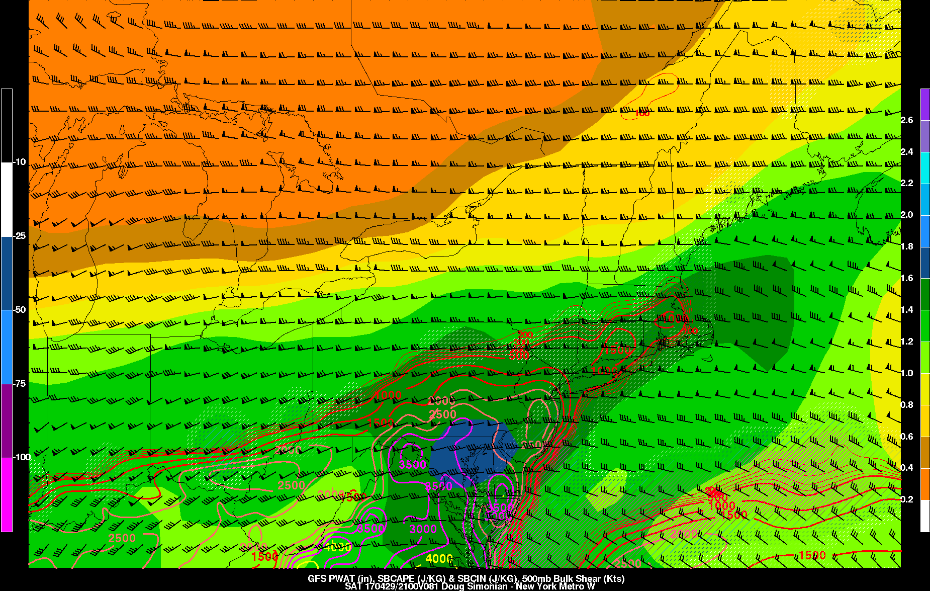
This morning’s GFS valid for Saturday afternoon shows a good combination of CAPE and wind shear for the formation of strong to severe thunderstorms.
The EML provides a plethora of instability aloft as it starts off very warm at its base, but quickly becomes colder and drier with height — warm air that quickly cools with height is inherently very unstable, especially if it’s somewhat dry (but not too dry) and can thus cool even further via wet-bulbing. Its warm base also provides a cap since it’s warmer than the air beneath it and this cap precludes any weak convection from stabilizing the atmosphere. The strong westerlies aloft also provide plenty of wind shear and the warm and moist low-levels provide low-level buoyancy and instability to go along with the instability aloft. Plus, precipitable water values are forecast to near 1.5″ — all good ingredients for the formation of strong to severe thunderstorms.
The storm/shortwave in SE Canada may end up being a lifting mechanism for storms and the fast westerly flow may also send vorticity into the area on top of the ridge. So in theory, this setup is nearly ideal for severe weather. But the big question is how far south does this backdoor cold front go — who wins the battle between the ridge to our south and the trough/shortwave to the north. The ECMWF model shows the backdoor cold front reigning supreme and thus keeping all the moist and unstable air to our south, and also keeping the EML to our south, which would mitigate the severe weather threat entirely. This battle will be tough to forecast and we will be sure to keep you updated. Regardless, Saturday could again reach 80 degrees or higher, even if the airmass ends up more stable.
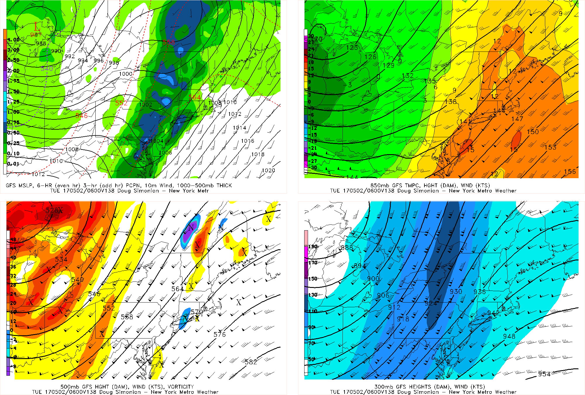
This morning’s GFS model valid for Monday night shows a dynamic storm system triggering heavy rain.
Even if the backdoor cold front remains to our north during the day on Saturday, it should eventually pass to our south on Saturday night and Sunday, cooling temperatures off a bit on Sunday with highs in the upper 60s with partly sunny skies. But a very strong disturbance that may even trigger a blizzard in the Northern Plains will be moving towards the area on Monday. Out ahead of this storm, we will be back into the warm sector and thus be able to warm into the upper 70s. This storm will be so deep that it will tap into the Gulf and send a very moist airmass into the region with precipitable water values over 1.5″. The strong temperature gradient with this storm will also lead to a very strong cold front that will push towards the area on Monday night. Also notice the very potent jet streak on the bottom-right panel — we are in the right-entrance region of that jet, which is favorable for upward vertical motion. Put all of these ingredients together and you get the potential for a forced line of convection that brings tropical downpours to the area on late Monday night into Tuesday.
Although it may dry off for a couple of days afterward, it does appear that a strong blocking pattern will develop in Greenland. This favors a strong coastal storm to form late next week which could give the area more heavy rain. There will be lots of weather to track for sure!