-2")
PM Zones: Scattered T-Storms Tonight, Heavy Rain Likely Friday
Good evening! After a chilly, overcast start with low clouds, a warm front was able to push through the area, which generated enough lift to mix out the marine layer — leading to increasing sunshine and warmer temperatures. For the most part, we got up into the 70s today for highs. This pleasant weather will last into the evening, before a strong cold front approaches the area, which could lead to some scattered showers and thunderstorms.
As we speak, a very strong line of showers and thunderstorms extends from West Virginia through Upstate NY and is making its way towards State College. These locations could have plenty of severe weather with damaging wind gusts and even a few isolated tornadoes. This is associated with a large closed 500mb low in the Great Lakes. The main forcing for these storms is this strong 500mb low and a potent jet streak just ahead of it, as well as a diffluence zone underneath this jet streak, all helping to promote lift for thunderstorms in a very warm and moist airmass.
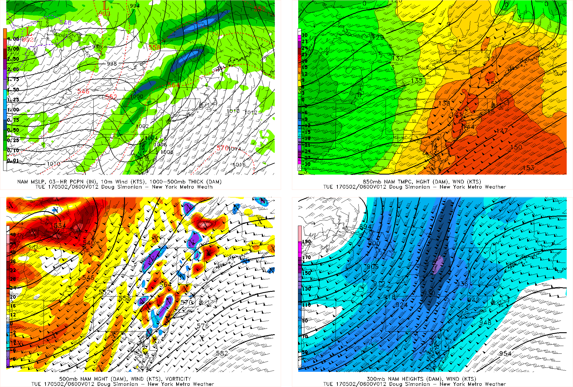
Today’s NAM model valid for 2:00am Tuesday morning shows the thunderstorms to our NW weakening, but a new cluster of storms forcing to our south.
However, as these storms continue to head northeast, they will be outrunning the best forcing as they further separate themselves from the cutoff low. Additionally, the low-level airmass in our area is more stable, so the storms will also be weakening for that reason. There is a very strong jet streak in Upstate NY, which places NE PA in the right-entrance region of that jet. But that jet streak will be significantly weakening as the night goes on, effectively shutting off that lifting mechanism. This all will lead to the initial line of storms to weaken.
But notice the very strong 850mb winds on the top-right panel, as well as a second batch of precipitation forming to our southwest. This is triggered by the 850mb jet and an even stronger jet offshore at 925mb. Additionally, there will be an area of moisture convergence that results from this jet. This will lead to a second cluster of showers and thunderstorms forming in Maryland, Delaware, and SE NJ later this evening which will then move up the coast.
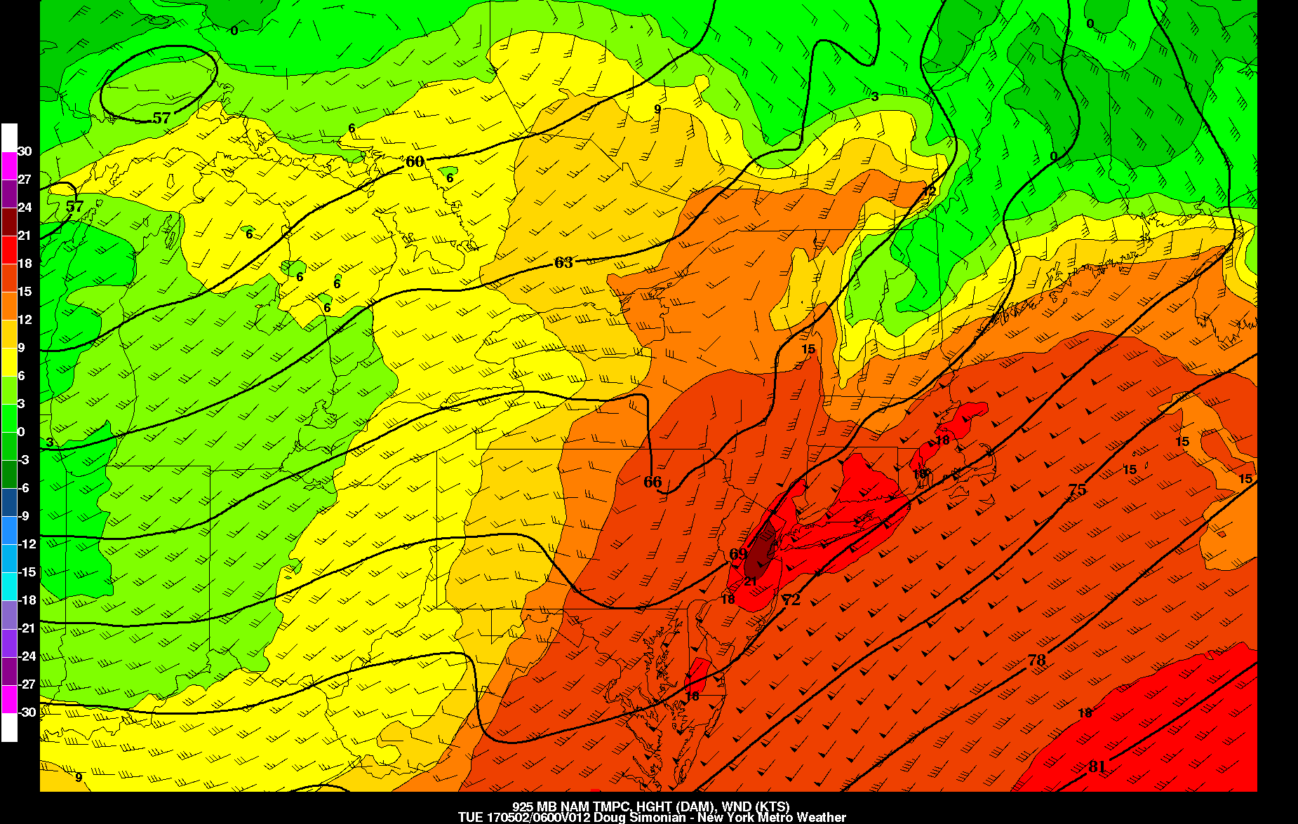
Today’s NAM model valid for 2:00am on Tuesday morning shows an extremely strong 925mb jet, which may trigger some showers and thunderstorms.
Notice the extremely strong 925mb jet above, and the relative jet maximum in Central NJ. This will also help to trigger some isolated showers and thunderstorms in the area, while the main cluster forms to the south. This jet further supports the formation of the cluster of storms to the south and they should ride the coastal plain and give the area showers and thunderstorms later in the overnight. With precipitable water values over 1.5″ and instability aloft, there could be heavy downpours as well as frequent lightning. However, the low-levels will still be stable and the upper-level forcing still simply will not be there, which will both limit the extent of the coverage as well as the severity of these storms. Additionally, notice how the core of the 925mb jet shifts a bit offshore in the image above — this may act to keep the main part of this cluster a bit offshore or only in parts of Long Island as it tries to get to our latitude.
After this front comes through, more tranquil weather is expected on Tuesday and Wednesday. Tuesday should still have enough downsloping and mixing behind the front for temperatures to reach the upper 60s to low 70s. Additionally, the mixing behind the front as well as impressive wind fields could mean wind gusts between 30 and 40mph. A reinforcing cold front will move through on Tuesday night, leading to chillier weather on Wednesday, despite the mixing — temperatures may only reach the low 60s with afternoon instability clouds from the colder temperatures aloft.
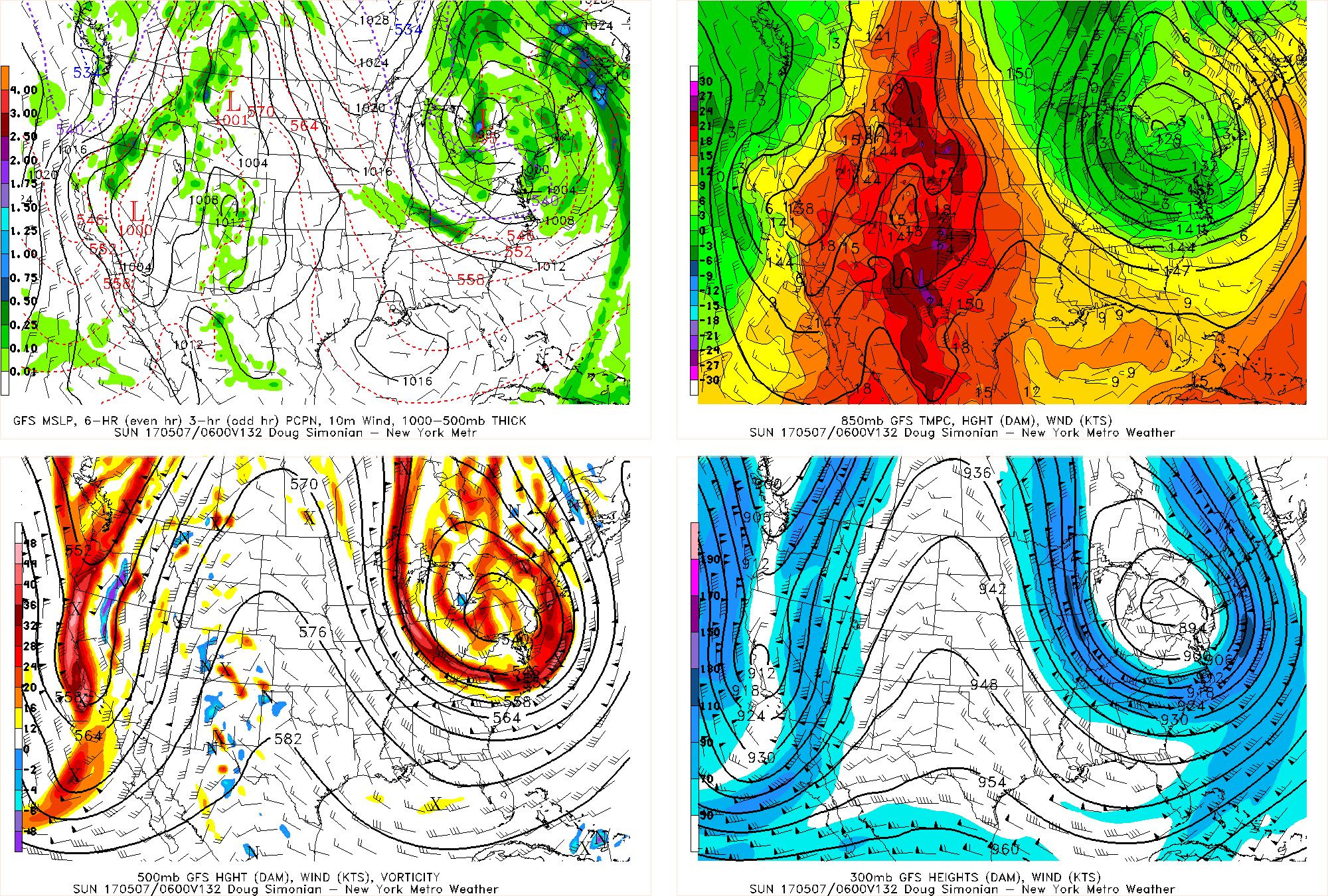
The big story in the extended period is the strong likelihood of a large storm system to affect the area on Friday.
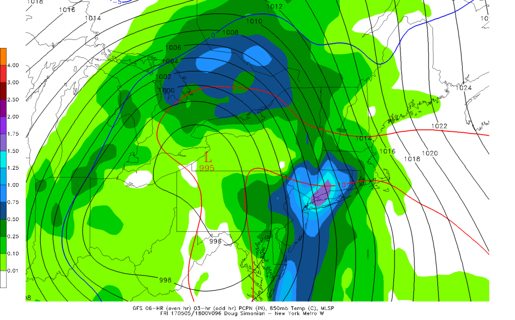
Today’s GFS model valid for Friday morning shows a powerful, wrapped up storm system bringing heavy rain to the region.
Notice in the bottom left panel how organized the system is at 500mb and how it’s closed off circulation. This is forced by a strong blocking pattern developing to our north, which forces multiple pieces of energy to phase together to our southwest, yielding a quickly intensifying and growing storm system riding up the spine of the Appalachians. This storm is large enough to gather a Gulf of Mexico and Caribbean moisture fetch, which gets enhanced by the Gulf Stream and Atlantic as well as an extremely potent low-level jet bending from the Atlantic, northwest into the area. Notice the powerful and expansive 850mb jet in the top right image — between 50 and 70 knots. The storm is also quite expansive, so lift will be much more widespread than it was during last Tuesday’s cutoff low.
This causes plenty of heavy rain to already gather in a good chunk of NJ, and then the low-level jet which acts like a firehose helps to further enhance the precipitation as it heads northeastward into our area later in the morning and into the afternoon.

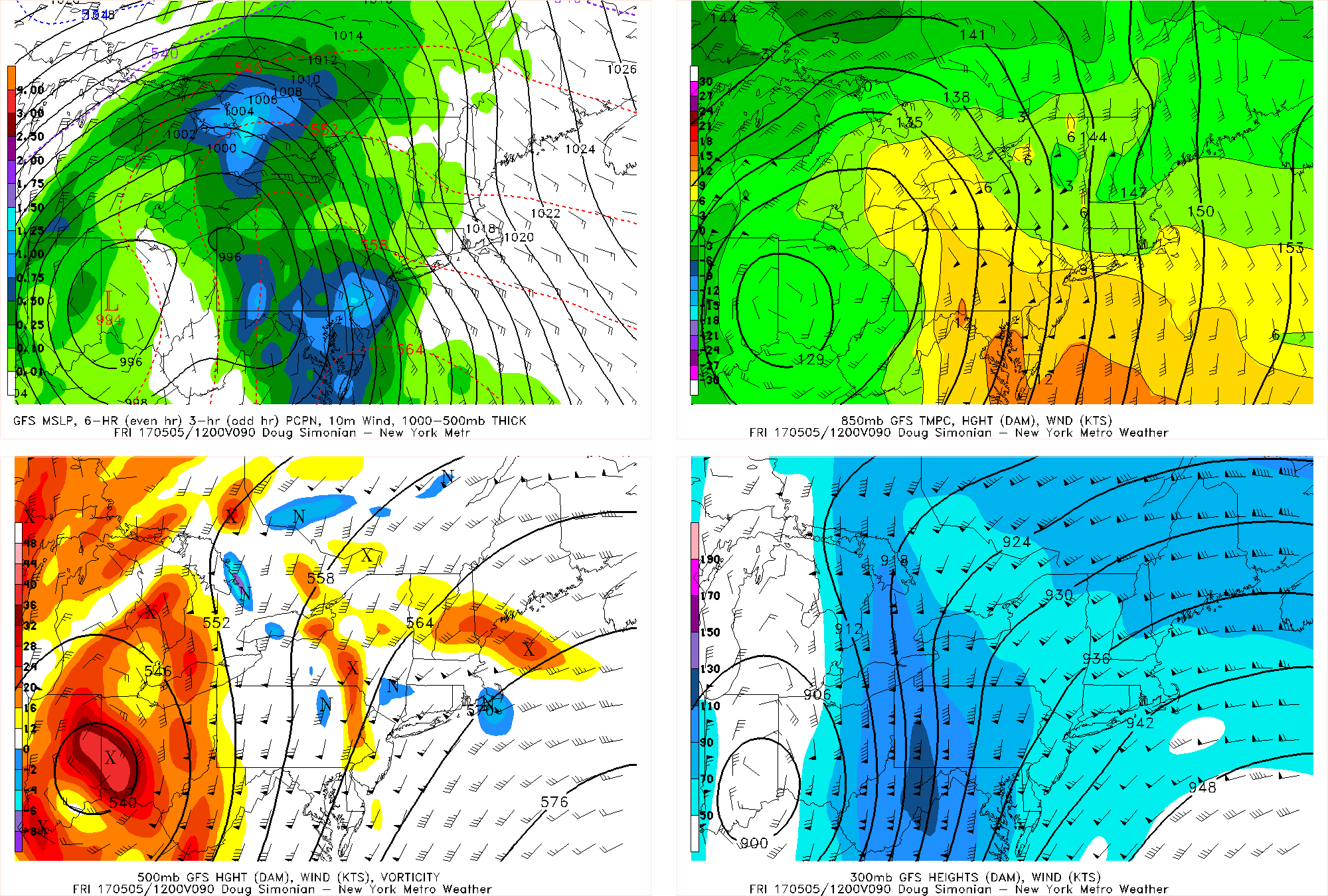
Today’s GFS model valid for 2:00pm on Friday shows that 1.5″ of rain has fallen in parts of the area in the 8:00am through 2:00pm period.
Thus, this afternoon’s GFS model shows in excess of 1.5″ of rain in just a 6-hour period on Friday morning into Friday afternoon for parts of the area. This is further supported by the fact that we are combining the deep low-level SE flow from the Atlantic with the LLJ with deep SW flow aloft — mid-level moisture and atmospheric instability on top of the LLJ. During last Tuesday’s cutoff low, the winds aloft were still SE, which does not promote as much instability aloft.
This, plus the more expansive lift in the atmosphere means that we are expecting more rain to fall than we got on Tuesday. We will still have the firehose jet from the Atlantic training heavy rain over the same areas, but combined with even more lift, moisture, and atmospheric instability. This means a good chunk of the area may be able to pick up 2″ of rain with locally higher amounts, before the storm occludes later on Friday night. Flash flooding is possible in the heaviest downpours.
Today’s GFS model valid for Saturday night shows the storm getting caught underneath the blocking, forcing an upper-level low to expand and stall near our area for quite a while.
This storm will move into Quebec but get caught in the blocking, so it will stall there. In fact, it will act to enhance the blocking and shift the blocking closer to our area. This promotes some moisture aloft pivoting into the area as well as chilly temperatures behind the powerful storm as well as instability aloft, so clouds and showers with temperatures holding in the 50s is possible this weekend. Additionally, as this storm rotates and sends in more cold temperatures aloft from Canada, it’s possible that areas well in the interior could see sleet and even snowflakes late in the weekend and next week if any showers arrive at night. This blocking pattern looks to stick around for a while, so unsettled weather with chilly temperatures will remain in the cards through next week, as upper-level lows get trapped underneath the block, forcing storm systems to back in from the Atlantic and giving us more rain.