-2")
Public Analysis: Heavy Rains Likely Friday, Below Normal Temperatures Next Week
Good afternoon!
After the strong cold front that came through on Monday evening that brought some showers and thunderstorms to the area, we are finally back into a rather nice period of weather which started with yesterday’s mostly sunny skies and highs in the upper 60’s to lower 70’s. After another cold front moved through the region early this morning and brought a reinforcing shot of cooler air as well as drier conditions. These conditions should last though the day tomorrow, but a rather large storm system is once again gathering strength to the south and looks to impact our area on Friday with heavy rains and some gusty winds.
Today Into This Evening
As mentioned, we had a cold front push through the area early this morning which brought in yet another cold shot from deep into Canada, in addition to clearer and drier conditions. As of 2pm this afternoon, temperatures around the area were steady in the upper 50’s to lower 60’s across the entire area. As weak residual energy associated with the old cold front exits the region, spotty clouds and maybe a very light shower may be possible (especially over portions of Connecticut). However, as this residual energy continues on quickly to the east, high pressure from the west currently over Great Lakes region will move towards our area this evening and into tomorrow morning. As this high moves east, clouds should gradually dissipate and be replaced by mostly clear conditions as we head into the late afternoon and evening hours.
It is worth noting that there will still be a rather impressive pressure gradient still over our area the rest of this afternoon due to the interaction between the advancing high pressure to our west and the retreating low pressure off of the Canadian maritimes. This will support some gusty winds until sundown of around 15-25 mph, which may also make it feel a little cooler than it actually is, despite temperatures being right around normal for this time of year.
As we head into this evening, the combination of clearing skies, cool mid level temperatures in the atmosphere, and subsiding winds will lead to perfect conditions for a rather cool night for the entire area as radiational cooling takes place. Most of the immediate New York city area, should remain in the mid to upper 40’s, but as you head away from the coast, low temperatures will have the potential to dip into upper 30’s and low 40’s. Locations near the Pine Barrens may have a shot at seeing their coldest lows in a while as temperatures have the potential to fall into the middle 30’s. These lows will be around 5-8 degrees below normal, so it will definitely feel like we’re leaping back a few weeks during the early morning hours tomorrow.
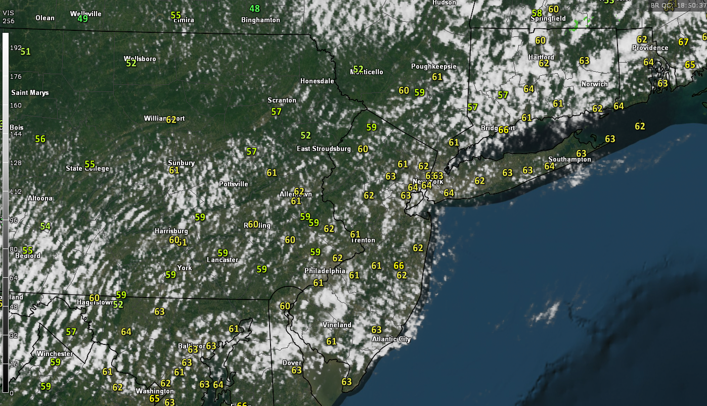
Latest regional radar mosaic, surface temperatures, and visible satellite imagery as of 2pm this afternoon showing clearing conditions from west to east (Courtesy of GREarth)
Thursday Into Friday Evening
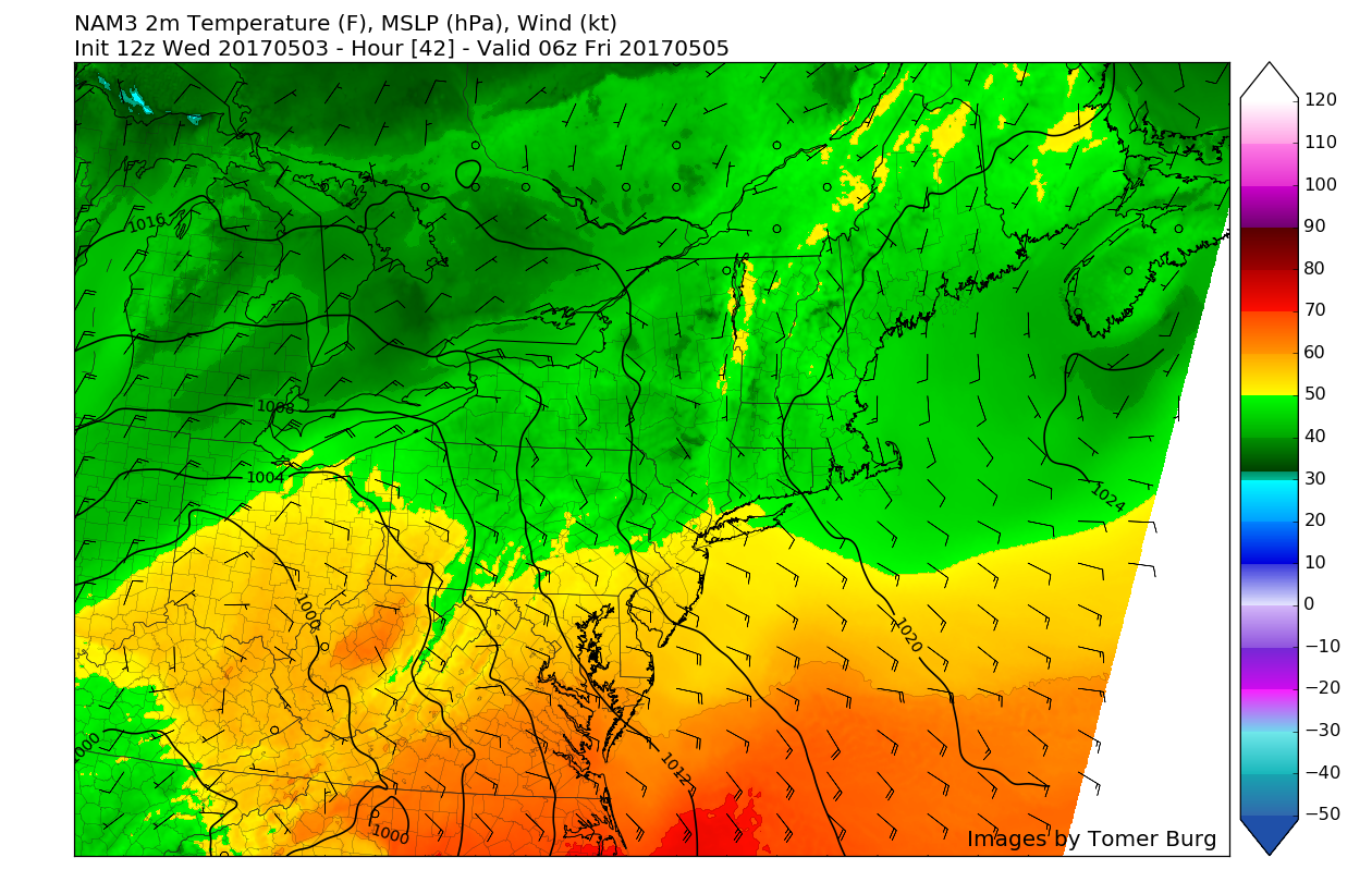
Tomorrow morning should start off rather sunny, but relatively chilly with temperatures likely staying in the 40’s for the morning commute. As the high pressure continues onwards to the east, it will change the wind flow from light northwesterly winds to southeasterly winds from off of the cool Atlantic. As we progress through the day, the chilly start and increasing cloud cover out ahead of the large storm system will effectively work to cap our highest potential temperatures tomorrow afternoon into the upper 50’s and low 60’s for most locations. With the addition of southeasterly winds, coastal locations will likely see highs a few degrees lower in the middle to upper 50’s, with the added possibility of some overcast as moisture begins to increase in the low levels of the atmosphere. As we get into tomorrow evening, clouds should continue to increase to the point that overcast will overspread the entire area before sunset. With weak winds coming off of the ocean, increasingly cloudy conditions, and a warmer layer of air working its way north, lows tomorrow will likely stay in the upper 40’s to low 50’s across the entire area.
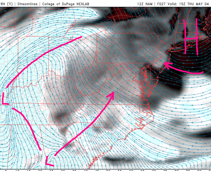
The main show for this period will be located to our southeast Thursday evening and into the early morning hours on Friday. The aforementioned negative NAO (North Atlantic Oscillation) that we talked about last week has indeed transpired, which will help to trap an energetic piece of energy currently located over the central portion of the country. As this piece of energy gets “trapped” but the blocking high pressure over Greenland, it will begin to phase, or combine energy with another system diving down from Canada. Once these two pieces of energy come together fully by tomorrow morning, the result will be a very large and impressive storm system. As this storm continues to intensify over the Tennessee valley, the storm will likely begin to take in a massive amount of water vapor from the south and southeast, and begin to transport that water vapor north towards our area. This is quite similar to what is often referred to as an “atmospheric river”, or a long fetch of moisture originating from a deep tropical airmass, which will have the potential to produce heavy rainfall. In this case, the source regions for the warm, tropical air mass will be the Gulf of Mexico and the southwestern Atlantic, both of which have above-normal sea surface temperatures for this time of year.
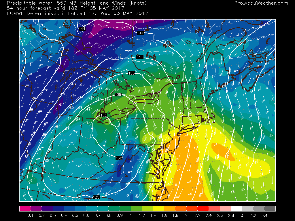
This afternoons European model showing the very impressive moisture feed pouring into the Mid-Atlantic coast during the day on Friday with associated strong mid-level winds (Valid 2pm Friday)
In addition to the very impressive moisture feed from the south, the cyclone will have strong low level winds in the lowest few thousand feet of the atmosphere that will help to not only bring in more moist air, but also provide a mechanism for rising air in the atmosphere, which could generate isolated very heavy rainfall and training of storms. If we do see the low level jet strengthen like this afternoons model runs show, then there will be a potential for some localized flooding, mainly on roads with poor drainage as the rainfall rates quickly overwhelm the drainage systems.
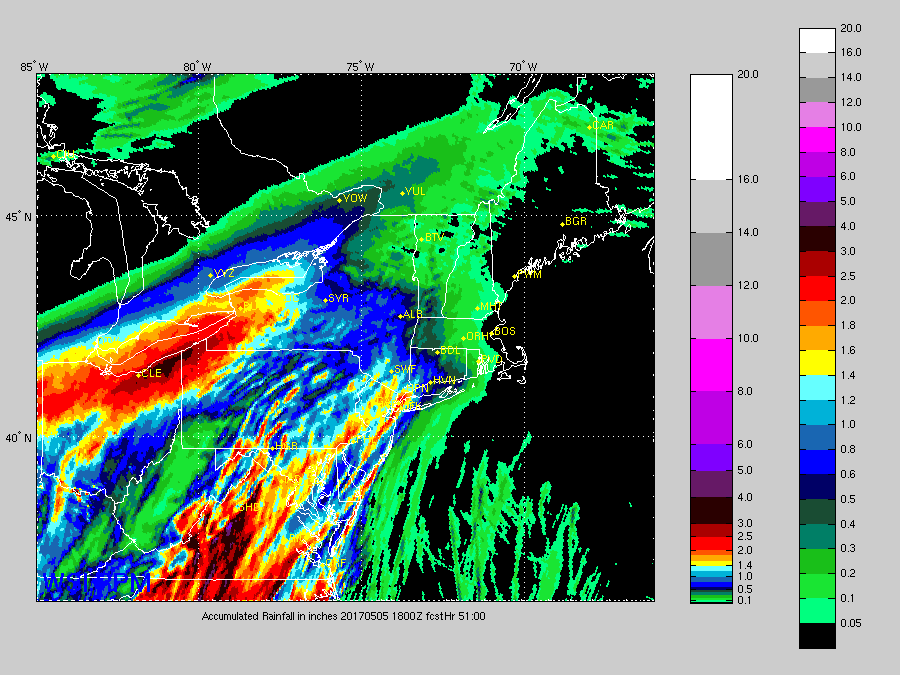
With a great number of details being highlighted this far out, there are some uncertainties regarding this system that will ultimately determine how much rain the region sees. For example, if we see the low level jet become more delayed in future model runs, then the potential for the heaviest rainfall will shift east to portions of southern New England. Additionally, the models have been trending more towards a quick hit of around 6 hours for the heaviest rainfall during the day on Friday. There is the potential that the models are sniffing out the potential for more convection to develop and affect the region, which may produce very heavy rains for some locations, but not nearly as much around that convection, or storms. At this time, we do feel that there is a reasonable amount of confidence in around 1-2″ of rainfall during the day on Friday, with some gusty winds of around 25-35 mph in the heaviest downpours. Local amounts of up to 3″ may be possible in areas that see training of the heaviest rain. Stay tuned for further updates on this storm over the next 48 hours, and make sure to check in with your local NWS for information on any watches or warnings that may be posted!
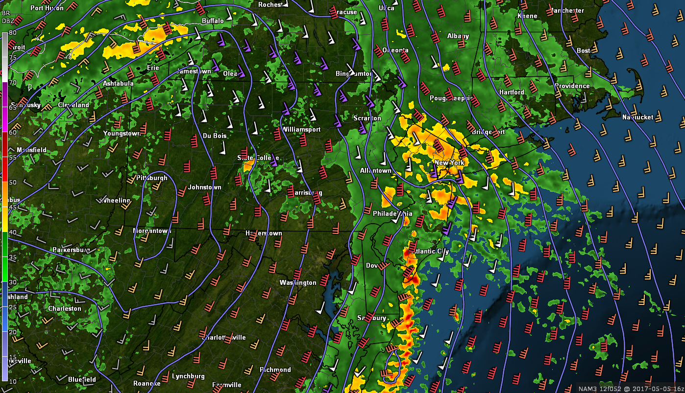
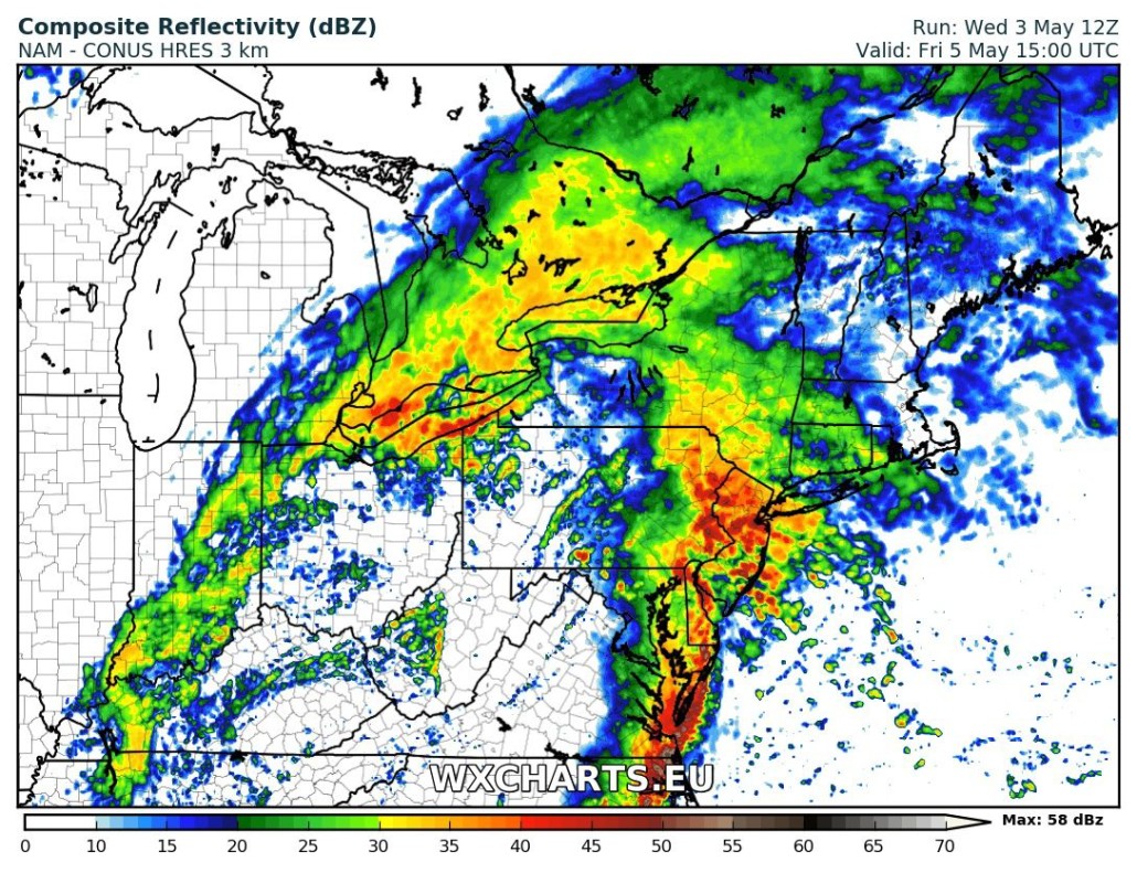
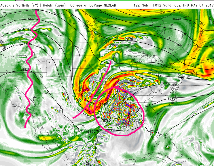
This afternoons high-resolution 3km NAM showing very heavy training showers and isolated thunderstorms over the NYC metro area by 12pm Friday afternoon
Saturday and Beyond
With the aforementioned negative to remain in place for the foreseeable future, unsettled weather is expected to continue through Saturday and into Sunday as the storm system becomes trapped and will potentially deliver some cloudier weather once again with the potential for showers on both days. Into next week, high pressure diving down from Canada may briefly stabilize things while simultaneously providing below-normal temperatures for the vast majority of next week. Make sure to stay tuned for further updates on this potentially significant system!
—–
For more information and posts like this one, make sure you sign up for Zone Forecasts — where multiple detailed articles, videos, and interactives are posted each day. Also, come interact with our staff and many other weather enthusiasts at 33andrain.com!
Have a great evening!
Steve Copertino