-2")
5/3 AM Zones Update: Chilly and Breezy on Wednesday; Heavy Rain on Friday
Good morning, everyone! We had a beautiful day on Tuesday with mostly sunny skies and highs in the 70s, though it got pretty windy in the afternoon. Unfortunately, we will not be seeing 70s again anytime soon as a large blocking pattern has developed near Greenland, which will generally help for deep troughs to form in the means in the Northeast. Temperatures were pretty mild during most of the overnight ahead of a second cold front that will be pushing through the region this morning. Considering we just had a cold front that came through on Monday night that dried us out, and the fact that this second cold front is all northern-stream driven and thus has little moisture return will mean that this cold front will be a dry frontal passage.
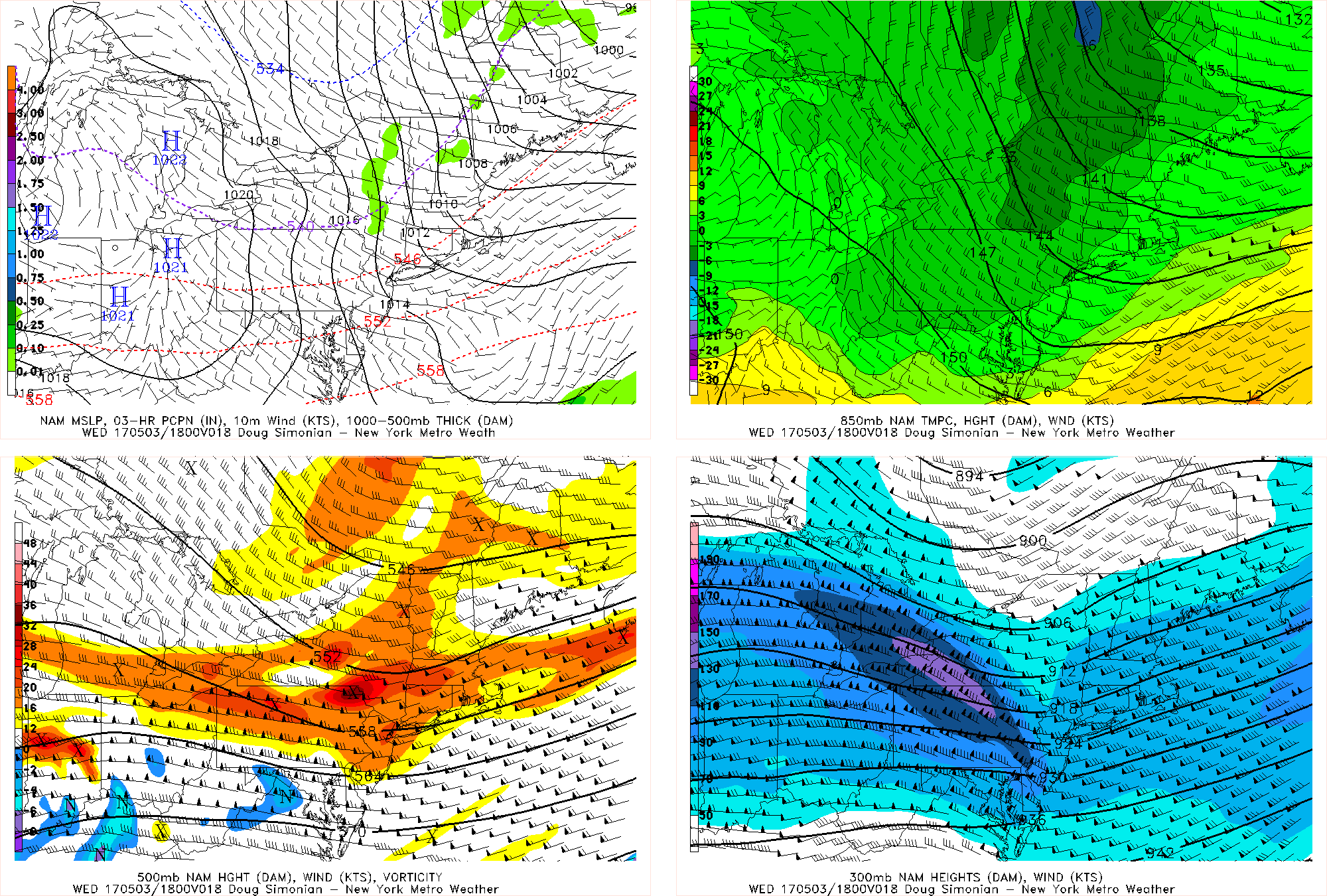
Last night’s NAM model valid for 2:00pm today shows a shortwave trough and strong jet streak that may lead to some clouds.
However, this front is associated with a shortwave trough with a decent amount of vorticity at its base, as well as a 130+ knot jet streak in PA. The above image is valid for 2:00pm — notice the direction of the jet streak being NW to SE — that actually places us in the left-exit region of that jet. These factors will mean an increase in clouds in the late-morning and early afternoon to partly sunny/mostly cloudy. Combined with the chilly airmass with 850mb temperatures only around 0°C, we may struggle to get out of the 50s for most of the day. However, notice how at 500mb, there is a good amount of ridging right behind that shortwave trough and there is also surface high pressure to the west. This will move in later in the afternoon and allow clouds to again decrease to mostly sunny skies. When combined with strong downsloping west and northwest flow, we may be able to squeeze a late-afternoon high in the low 60s, or even mid 60s if the clouds can break early enough. The coast will see similar readings rather than being chillier due to the relatively strong offshore winds mitigating any sea-breezes.
There is still a pretty good pressure gradient as evidenced by the top-left image, so winds will generally be between 10-20mph once again. Winds will not gust as high as they did yesterday, though, as the winds on top of the mixed layer are not as high — notice how the 850mb winds are only around 20 knots. This means that gusts may reach 25mph at times, but not much higher.
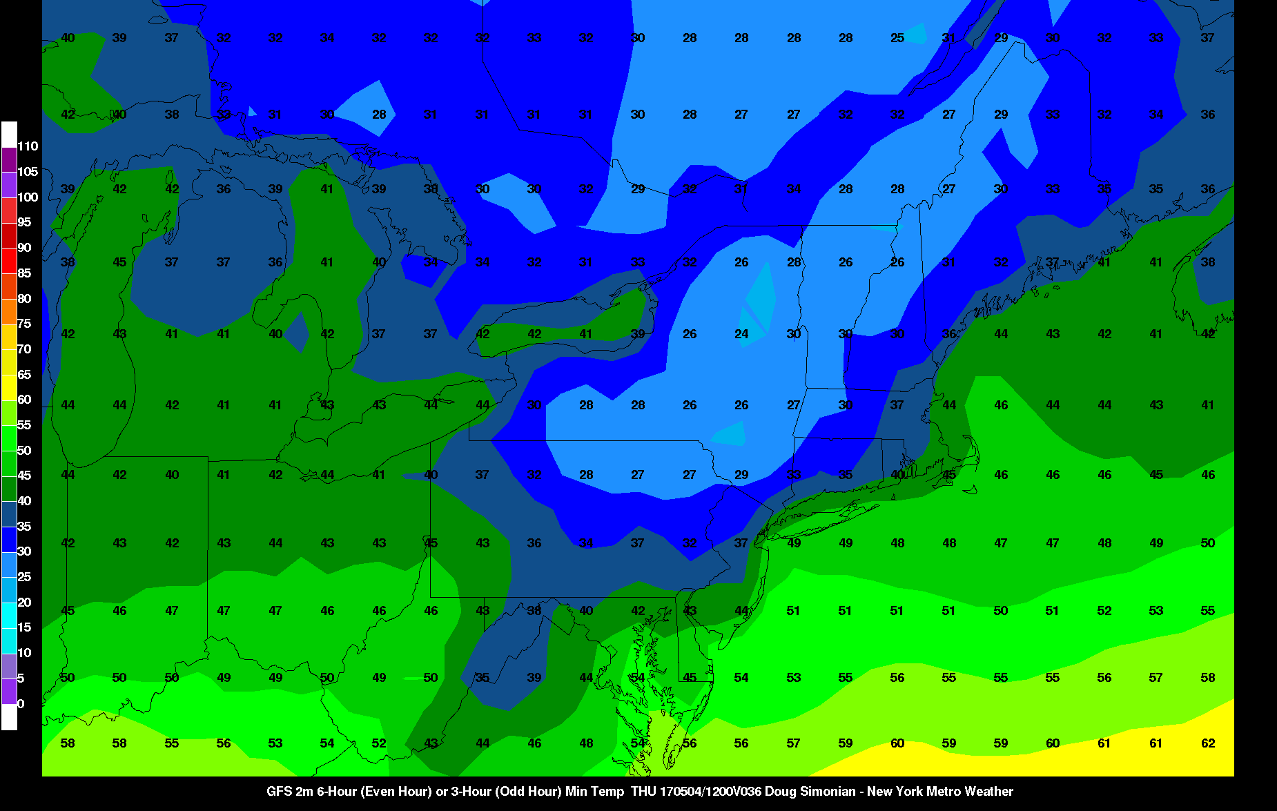
Last night’s GFS valid for Thursday morning shows lows in the upper 30s for a good chunk of the NW NYC suburbs.
Wednesday night/Thursday morning look quite chilly. This is because the chilly airmass and low dewpoints will finally be accompanied by much decreased winds as the high pressure from the Ohio Valley moves into the region. This will also help clouds decrease even further, leading to good radiational cooling conditions. Thus, most suburbs west and northwest of NYC will fall into the upper 30s to around 40. Suburbs further NW of I-95 in elevated valleys as well as the Pine Barrens may even fall into the low to mid 30s and see some frost. The city itself will hold in the upper 40s.
Thursday will start out mostly sunny, with high pressure still in control. But mid and high level clouds will increase by afternoon, out ahead of a large storm system in the south, as warm and moist air aloft start to advect into the region. The chilly start combined with the increasing clouds will force high temperatures to hold in the low 60s, at least inland. Southeast winds with high pressure moving offshore, may keep highs in closer to coast in the upper 50s. Thursday night will be mostly cloudy with onshore winds keep the low temperatures from falling out of upper 40s to lower 50s, in most areas.
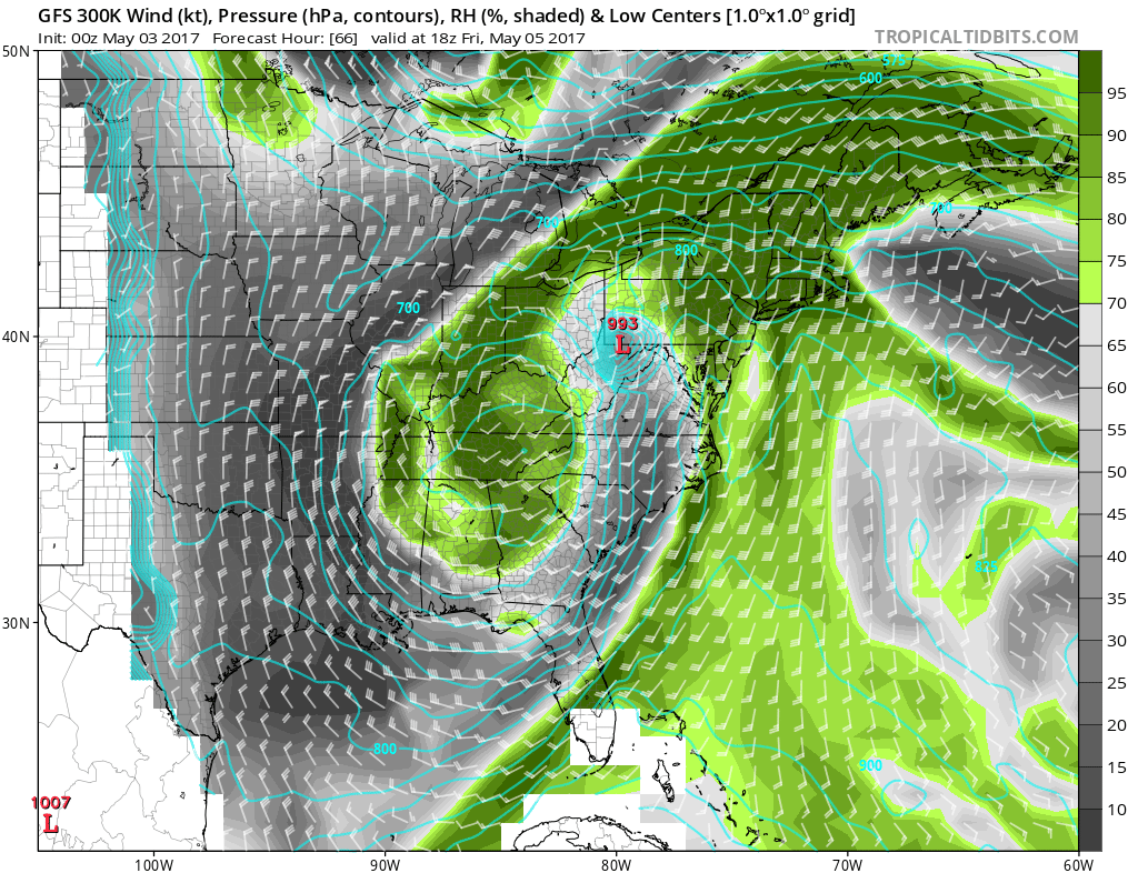
However, the big story is still the large storm system that will hit the region on Friday and bring some heavy rain.
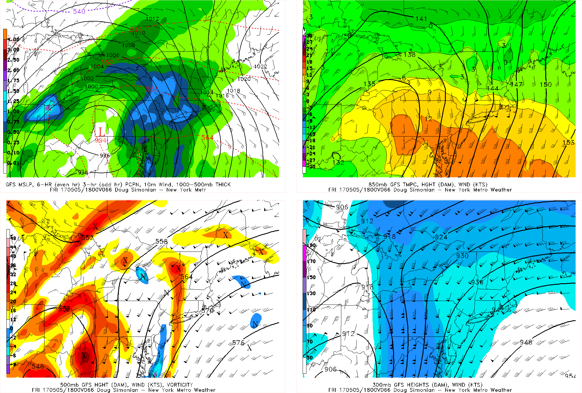
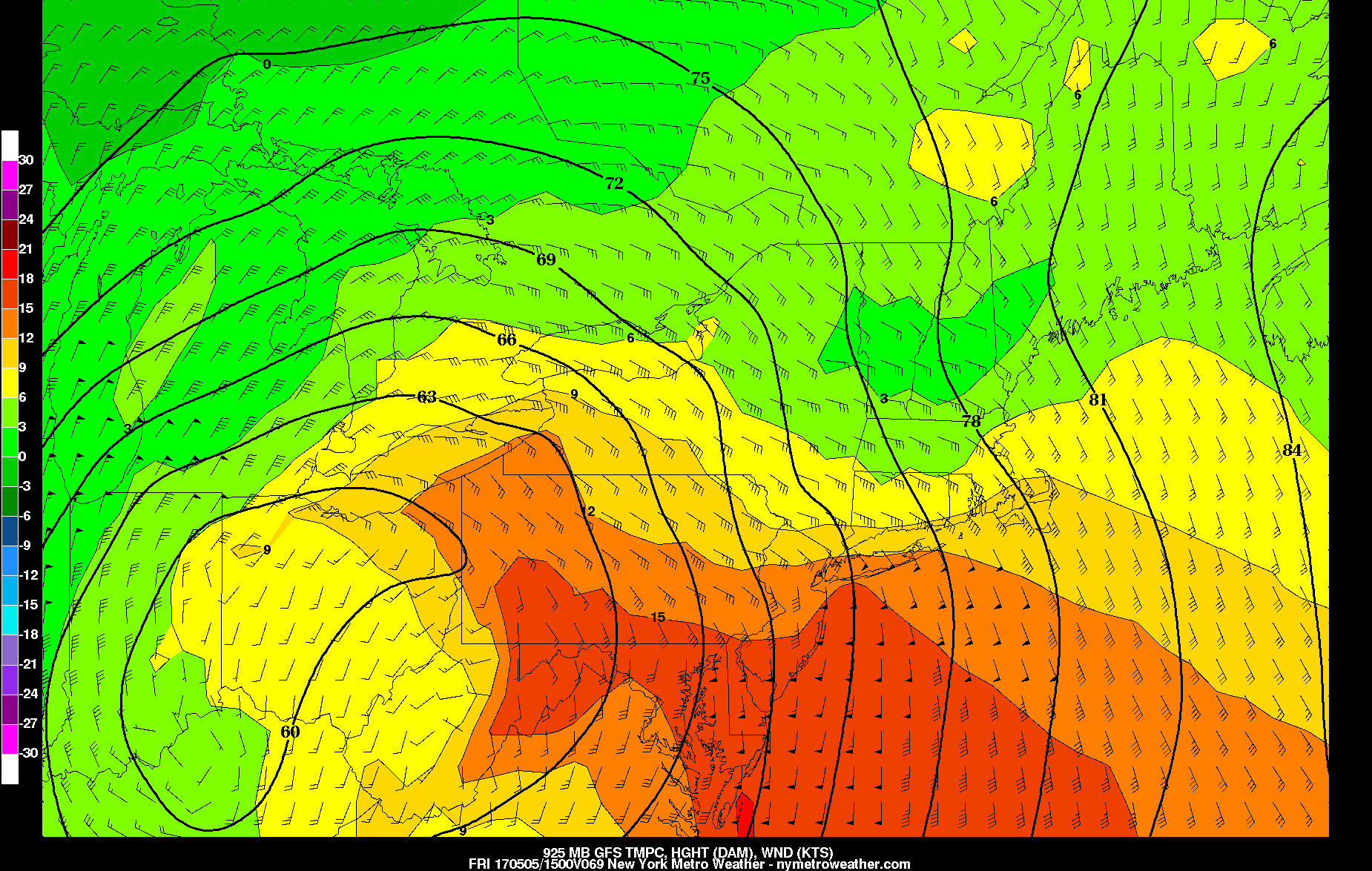
Last night’s GFS model valid for 2:00pm on Friday shows heavy rain has fallen across the region from a very strong storm to our southwest.
A blocking pattern will force a large storm to develop to our southwest, slow down, and phase with other pieces of energy diving down from Canada. This will turn it into a very large, wrapped up circulation that will ride up the spine of the Appalachians. Being to the northeast of a storm of this magnitude will lead to very deep southwest flow aloft in the atmosphere, sending Gulf of Mexico moisture up our way. Additionally, the low-levels of the storm closer to the surface will be wrapped up enough to bend the isobars somewhat back from SE to NW from the Atlantic and into the region, as evidenced by the top-left panel. This leads to a strong SE low-level jet, further helping for an Atlantic moisture fetch, moisture convergence as this jet slows down as it heads inland, as well as being a general lifting mechanism. Also notice the very efficient warm air advection at 850mb, with strong southerly wind barbs being nearly parallel to the isotherms. This combination will lead to heavy rain with the potential for flash flooding on Friday starting during the morning commute and lasting into the evening. The heaviest will be in the 9:00am through 3:00pm timeframe.
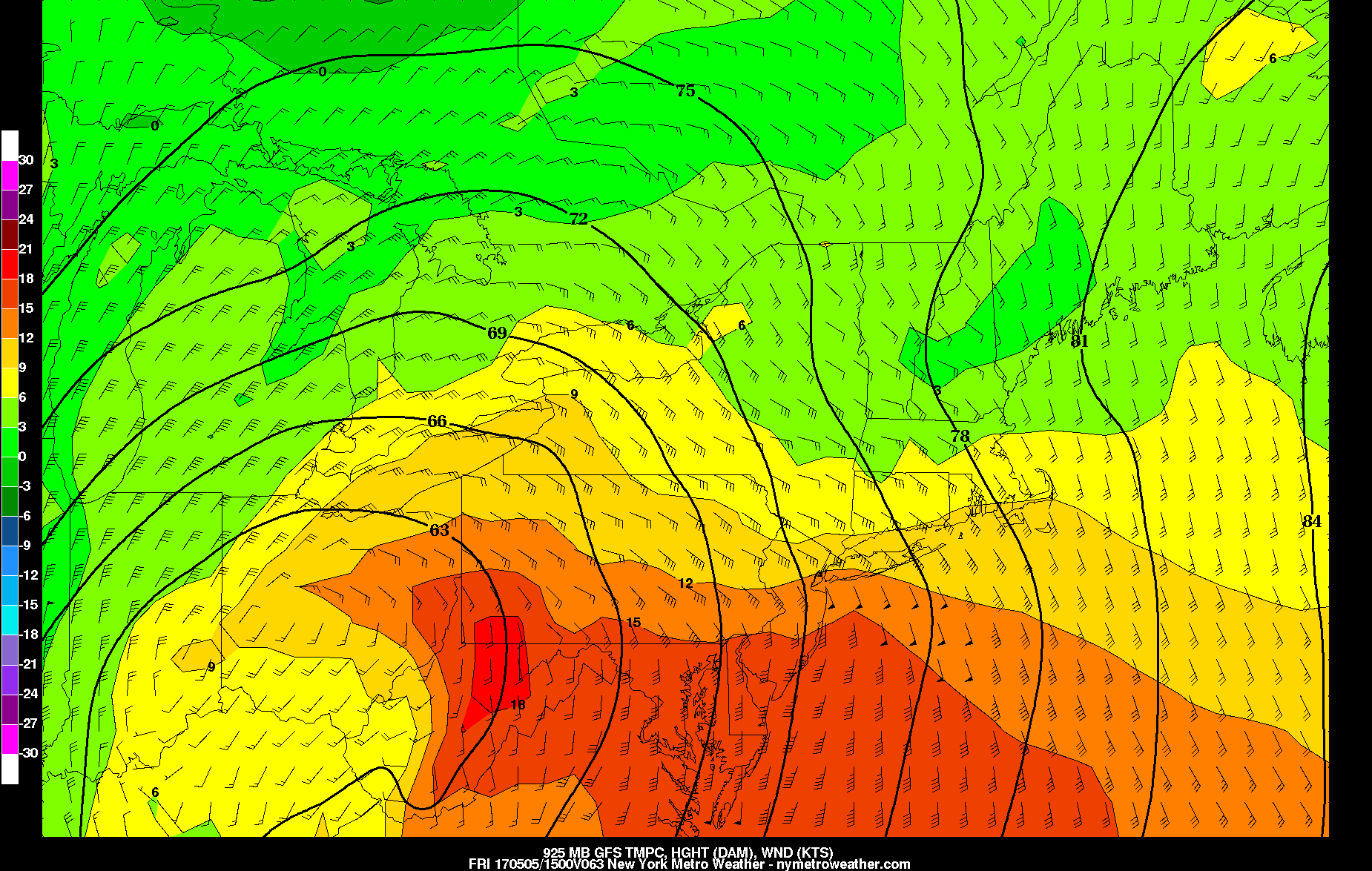
Last night’s GFS model valid for 11:00am Friday morning shows a strong 925mb jet, but the core of it misses S NJ.
The key to maximizing this rainfall event will be getting the low-level jet to mature early and bend back towards the coast. Notice how in the above image, the wind barbs are mainly south to north into Central NJ and do not strengthen and turn back to the northwest until just south of NYC. This would maximize the moisture convergence and “firehose” component to the low-level jet in N NYC, NYC, and Long Island, but it would lead to a relative hole in the precipitation further south. And even for the areas that get the heavy rain, the potential isn’t being reached with the lagged maturation of the jet and the core of it heading offshore.
If the storm can slow down a bit more and organize more quickly, this low-level jet would be a lot stronger and more expansive just off the coast, leading to more widespread heavy rain and moisture gets much more effectively pooled into the area. Yesterday’s 18z GFS run, valid for the same time as the above image, had a much stronger 925mb jet — if this were to instead verify, a widespread 2″+ rainfall event with flash flooding would be likely. If the 00z GFS jet verifies, then rainfall amounts would probably be on the order of 0.75 to 1.50″ with only locally higher amounts.
Unsettled weather will continue into Saturday and Sunday with the storm getting caught underneath the block, thus causing some upper-level moisture in a relatively unstable atmosphere to pivot into the region. However, this will only be in the form of scattered showers with perhaps one moderate burst of rain on Saturday, rather than a washout. Some peaks of sun may be had at times as well, particularly on Sunday. Temperatures will hold in the upper 50s to low 60s.