-2")
Impressive blocking will lead to cool, stormy pattern in Northeast
High latitude blocking is a term most often referred to in winter. The reasons for this are multi-faceted; its presence often leads to snowy and cold patterns during the Winter months, and dreary, wet patterns in the Spring months. Meteorologically, the latter is a far less popular outcome. However, popularity put aside, impressive high latitude blocking events can occur in any season. And when they do, their presence most often disrupts the pattern throughout the entire hemisphere.
This week’s high latitude blocking event will be no different. Ridging will build from Greenland westward into parts of Eastern and then Central Canada (an extremely negative NAO index, for those keeping score), remaining highly anomalous as it does so. In fact, the standard deviation from normal in the atmosphere’s mid levels makes this block one of the most anomalously impressive features on the globe at this time.
But what do high latitude blocks do, exactly? Why are they so important? The answer can be found in an understanding of the atmosphere’s wave pattern. Ridges and troughs make up the mid levels of the atmosphere, and they are constantly changing, elongating and progressing. Some patterns feature more progressive, faster waves than others. But blocking ridges are events in the atmosphere’s higher latitudes (in Canada, Greenland, the Arctic, etc) that cause, well, “blocks” in the wave pattern.
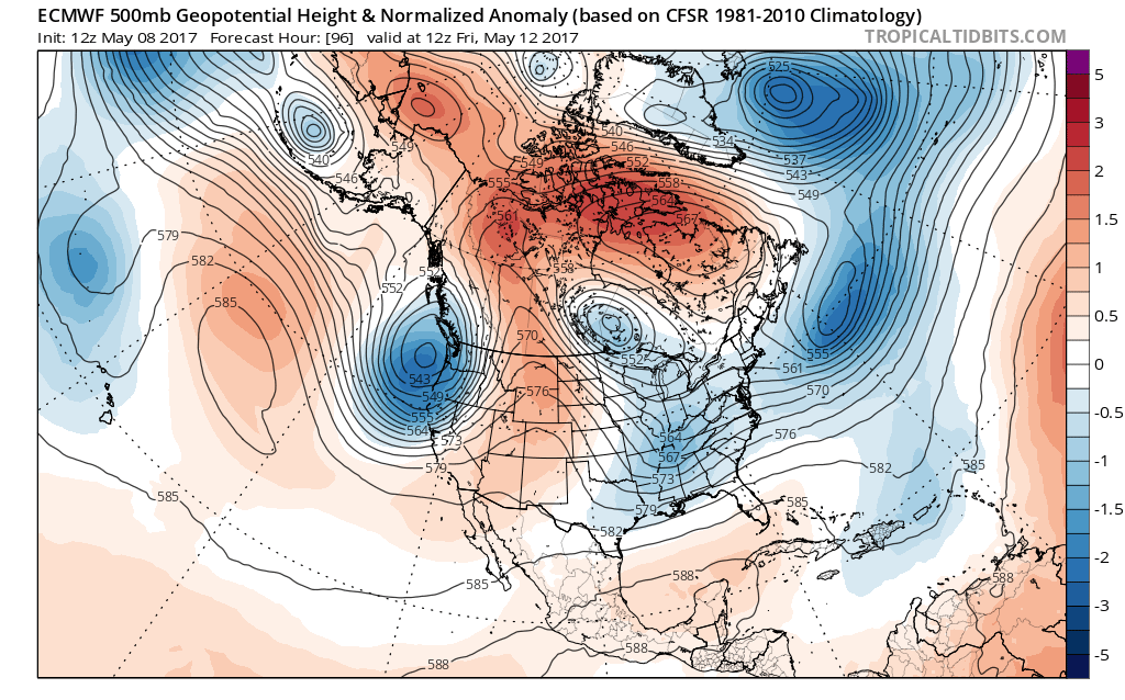
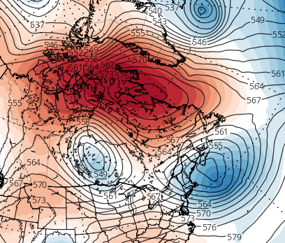
Today’s ECMWF model shows a strong blocking pattern SW of Greenland forcing two pieces of energy to phase together in the Tennessee Valley, generating a Nor’Easter for the weekend. (Tropical Tidbits).
These ridges clog up the atmospheric flow and change the progression of features around them. They also can dislodge cold air, normally bottled up in the arctic regions, to the south over Canada and the Northern 1/3 of the United States. This high latitude blocking episode is fairly classic in doing both aforementioned things. Cold air is being dislodged southward into the Northeast Untied States, and the height pattern across the Northern Hemisphere is being slowed down to support deeper, stronger systems.
By and large, this block will lead to unsettled and cooler weather this week (let’s not forget its presence aided in the development of last week’s big rainstorm). But it will culminate in the development of a potentially significant storm late this week. Energy elongated by this block over Southeast Canada will potentially interact with a second disturbance moving slowly over the Mississippi and Ohio Valleys. As the two interact, a low pressure system may gradually form over the Mid Atlantic and Northeast.
This afternoon’s GFS model valid for Sunday shows a more disjointed phase, resulting in the main coastal storm sliding out to sea, and instead the upper-level in the Great Lakes dropping in and giving us rain on its own. While rain would be briefly heavy in this scenario, it’s a much lower-impact event than if the phase were cleaner and the true coastal storm hit the area.
The interaction of these two features will, at the very least, cause very unsettled and cool weather this weekend. However, if they do interact in a more significant fashion — which often is encouraged by a blocking pattern — a more significant low pressure system could form. This would lead to a stronger storm system with the potential for heavy rain, wind, flooding and coastal impacts.
The devil is, as usual, in the details. Exactly how these two disturbances interact will be key. Our forecasters will be continually monitoring the presence of blocking, its strength and location; as well as the resulting position of the aforementioned disturbances as the week goes on. We’ll have more details as we draw closer to the potential event.
For now, stay tuned to the latest — and make sure to sign up for Zone Forecasts if you are looking for the latest information and local weather discussion updated each day with graphics, videos, and interactives!