-2")

Storm Chase 2017 Day 1: Cap concerns, analysis and more
It’s hard to describe what the first day of storm chasing feels like. A rush of blood and a little bit of pain. We’re heading out on the road, with a pit stop in Minneapolis’ North Loop neighborhood for breakfast and a coffee. While we’re on the topic — can’t speak highly enough about this city. A true gem in the middle of the country. We’ve taken time this morning to dive into a more detailed analysis of what to expect over the next few days and have narrowed down our targeting.
Saturday (Today)
After much discussion and deliberation, we have decided to head into Northern/Northwestern Wisconsin this afternoon. Confidence in the development of severe convection is currently extremely low. Uncertainties stem from the presence of an elevated mixed layer and capping. Essentially, these are functions in the atmosphere that act as a lid to prevent air from rising to form thunderstorms.
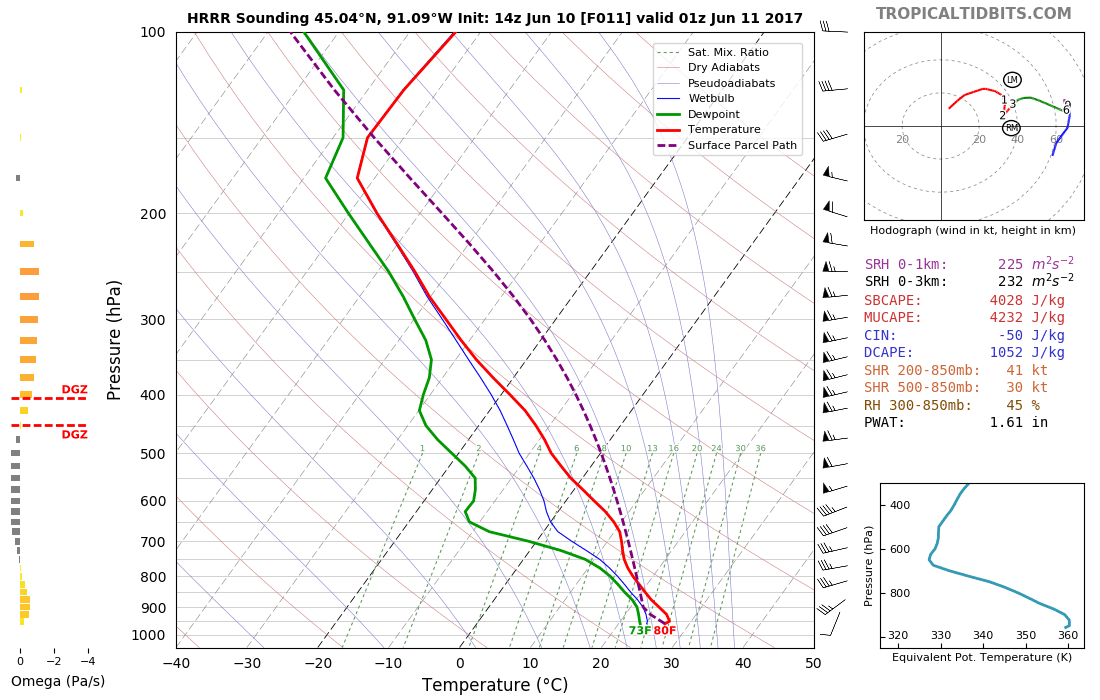
Forecast model sounding for Wisconsin showing potential for convective development.
Forecast models have been consistent in depicting a stout cap across much of Minnesota and Wisconsin later this afternoon, all the way through the afternoon and early evening. However, as a weak frontal boundary and pressure trough approach, enough lift may be generated in the atmosphere to aid in the development of thunderstorms.
The enticing thing about this setup, overall, is the presence of favorable wind fields, shear and high instability. This suggests that if storms do form, they could quickly become organized and produce strong to severe impacts (hail, winds, isolated tornadoes). With all of this in mind, we’re willing to take the hike up and properly position ourselves this afternoon.
Early Day Target: Rice Lake, WI
Sunday
The setup on Sunday looks explosive in terms of convective development, almost the polar opposite of Saturday, but awful in terms of discrete and/or tornadic supercell potential. Most chasers who are looking for supercell structure or strong tornadoes would turn away — but we are excited for the opportunity to see the severe convection being depicted on forecast models.
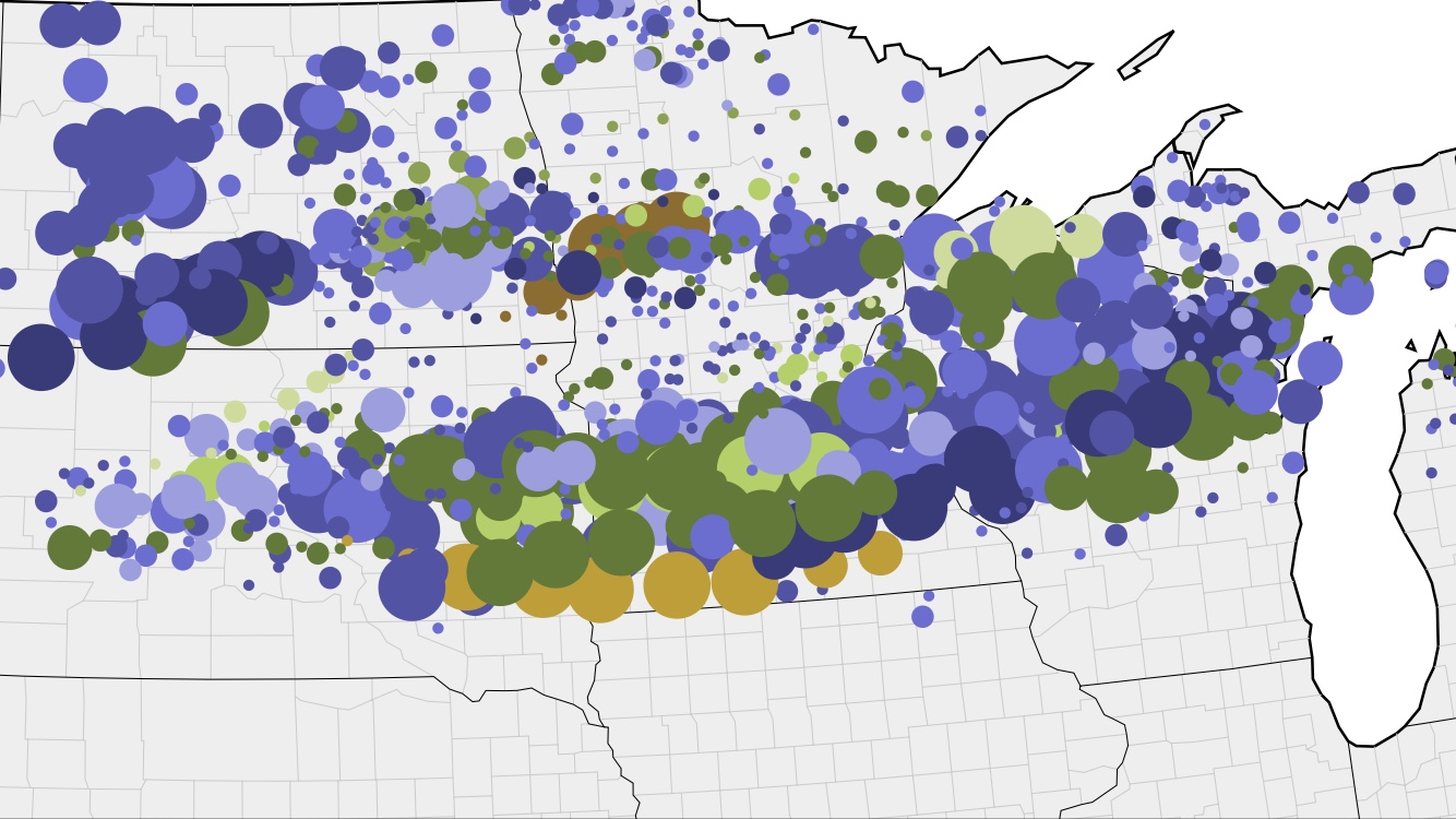
NCAR Ensembles showing the development of severe convection across much of Southern MN on Sunday.
A very notable moist boundary looks likely to develop northward from Nebraska and Iowa northward into South Dakota and Minnesota during the late morning. Forecast models are suggesting intense lift via a strong shortwave developing along this boundary, and the development of a very impressive thunderstorm complex along it.
While discrete convection isn’t supported with this initial activity, the potential exists for severe winds, large hail, and even a derecho as the system evolves. We’re excited for the opportunity to check it out as the system evolves rapidly east. Even better, it appears there will be a second, conditional threat for supercellular activity back further west in parts of Nebraska. We’re considering making a move for this activity based on how the latest models look.
Early Target: Fulda, MN (AM)
Stay with us today as we continue to analyze the threats and developments over the next few days. We have specifically left out Monday (we know you’re wondering) because of uncertainty in regards to the setup. We don’t have a comfortable target area yet.
Talk to you all soon!