-2")
Thunderstorms with Heavy Rain and Flooding Likely on Monday
After a very nice stretch of weather over the past couple of days, things have changed as we entered the weekend. While there will be some rain chances from today (Friday) through Sunday, we do not expect anything significant during that stretch. This article will focus on Monday, which has a higher potential to produce a myriad of impacts across the area, including strong to severe thunderstorms with heavy downpours and flash flooding.
A strong, dynamic trough will be pushing into the area from the Great Lakes and provide deep southwest flow across the entire atmosphere. This will advect plenty of moisture into the area, with precipitable water values over 2″ — highly supportive of heavy downpours and flash flooding. A strong cold front will also be pushing towards the area out ahead of this system, placing us in a warm sector which with the aforementioned deep southwest flow, should provide plenty of instability as well with SBCAPE values around 2,000 J/KG in some spots.
With winds at 500mb between 30-40 knots, this in itself should be able to provide some deep-layer wind shear for storm organization. However, the winds will be nearly uniformly southwest, so there is not much rotation in the atmosphere, and after some initial veering (clockwise turning) with height, they start to back (counterclockwise turning) closer to the middle of the atmosphere. This almost always goes very strongly against the idea of truly rotating supercells — as any rotation gets cancelled out.
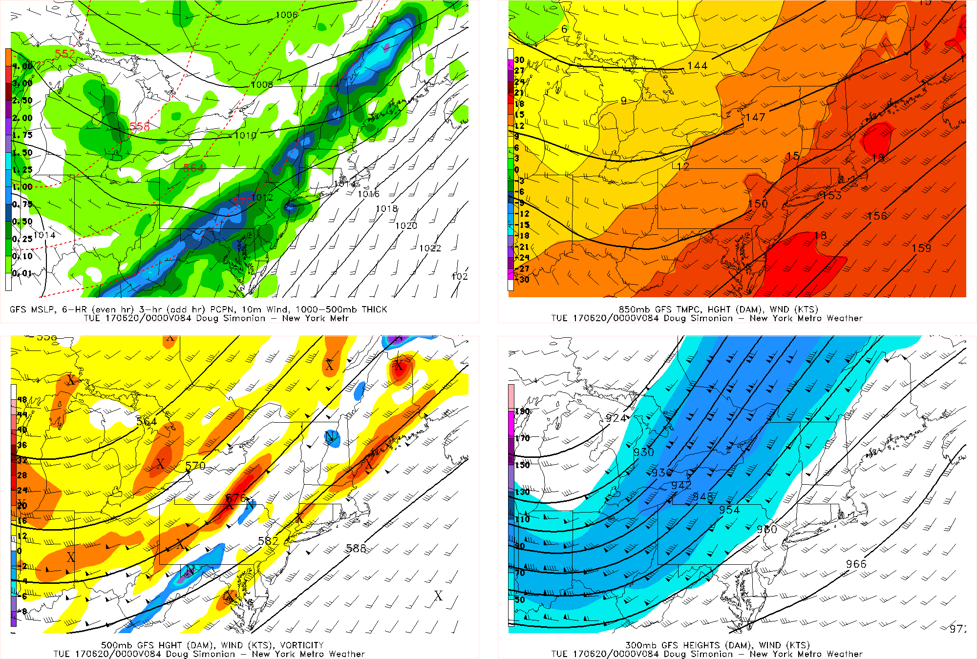
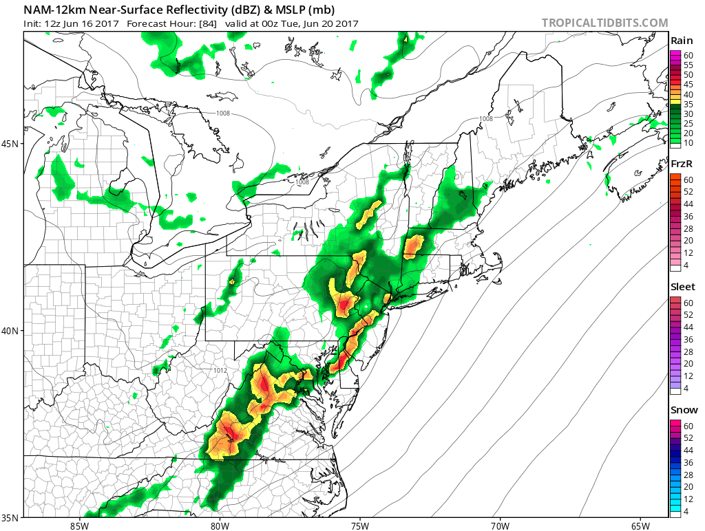
Friday’s 12z GFS valid for Monday evening shows a strong trough with deep southwest flow entering the northeast, and convective, training thunderstorms developing.
Also with winds nearly uniformly southwest, this means that storms will be moving from southwest to northeast. This direction is the same orientation as the angle of the cold front — and thus the storm motion will be parallel to the front and thus move along it rather than away from it. Considering the front can be the focal point of initial storm development and the storms will me moving along the frontal axis, that means that storms will be consistently forming on top of each other — like training thunderstorms. When combined with 2″ precipitable water values and the fact that a large Western Atlantic Ridge will serve to slow this front down, that means that these storms will be slow to move while they train over these areas, and thus the idea of flash flooding is there. Some localized areas could easily see 2-3″ of rain.
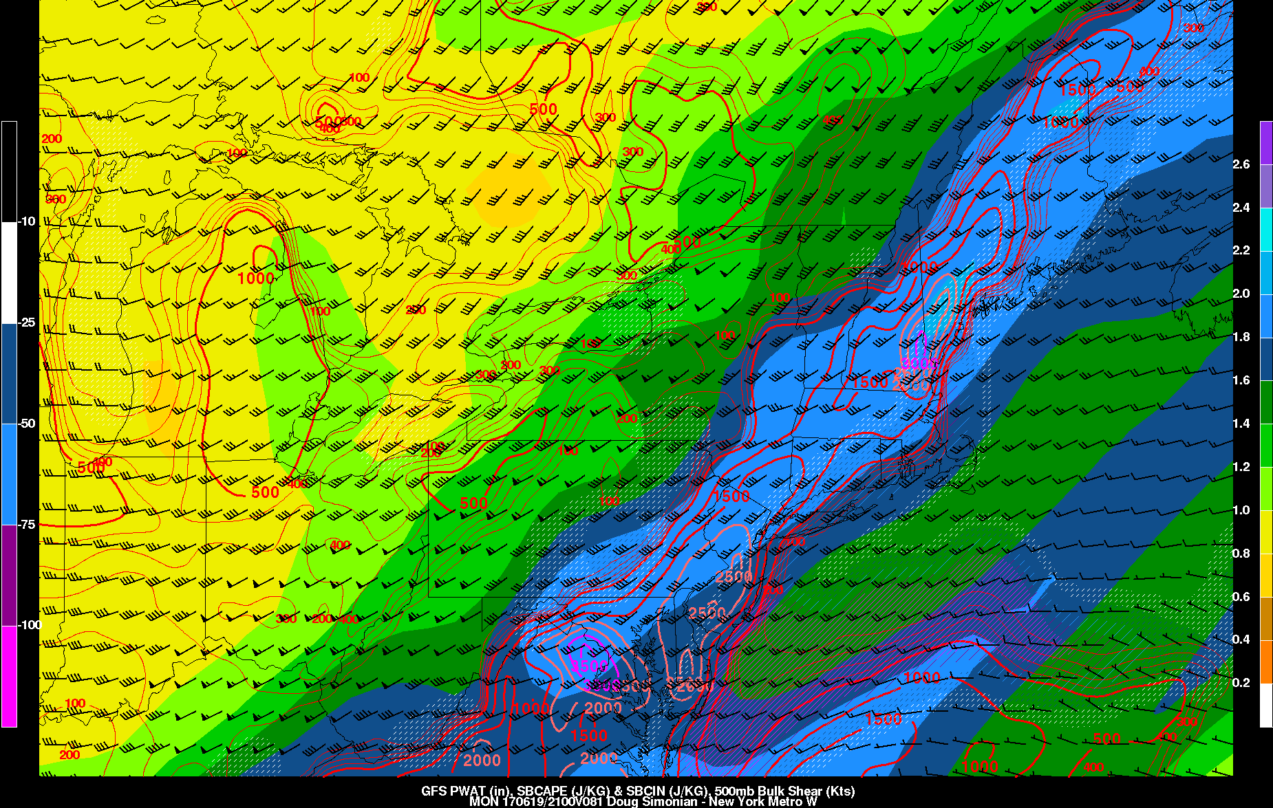
Friday’s 12z GFS valid for Monday afternoon shows a high amount of SBCAPE, high precipitable water values, and 30-40 knots of surface-500mb shear, all indicators of strong thunderstorms with heavy downpours.
Other good factors for heavy rain include the very strong jet streak that will be passing to our north, placing us in the right-entrance region for upward vertical motion. Additionally, forecast soundings do not show a true elevated mixed layer (EML) in the atmosphere, and instead have a “skinny” CAPE look to them. This further favors the idea of thunderstorms dropping heavy rain rather than a true severe weather threat. There also does not appear to be much of a cap in the atmosphere, so any updraft should be able to produce precipitation — if there were a cap in the atmosphere, then the weak updrafts would not survive and only the strong updrafts would remain, and thus stronger thunderstorms can more easily develop without being interfered with by the other weaker updrafts.
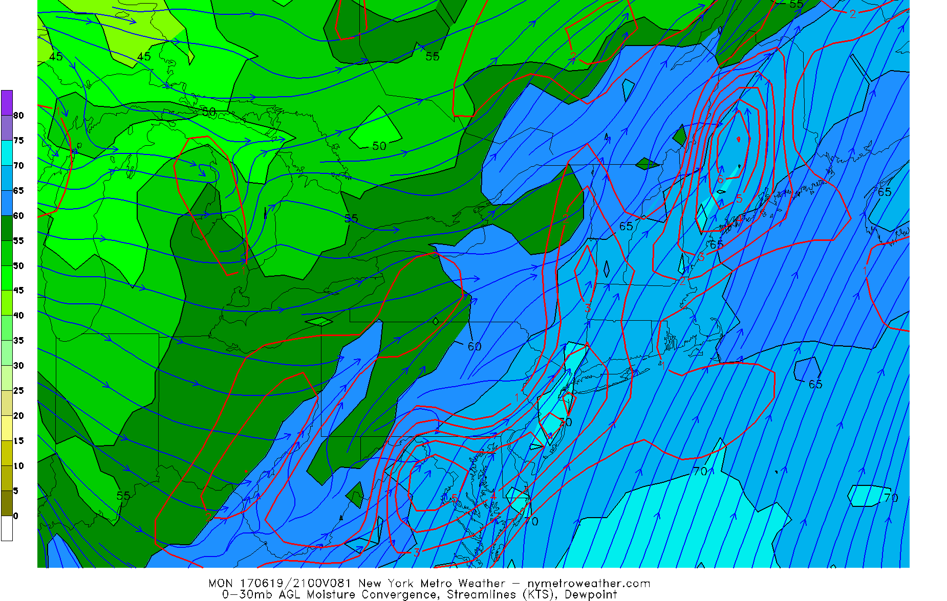
Friday’s 12z GFS valid for Monday afternoon shows very high low-level dewpoints and plenty of moisture convergence over the area, a good indicator for training bands of heavy rain.
There will also be plenty of moisture convergence, as low-level westerlies behind the front will converge with a very strong band of southwesterly winds out ahead of the front in our warm sector, some of which have a strong moisture component as is. This moisture convergence generally remains in the same areas all throughout Monday afternoon through most of Monday night, indicating that heavy rain will be possible for a pretty long period of time.
Sometimes what can happen, however, is that when a strong surface low approaches from the north, the isobar orientation isn’t linear — there can be kinks to it within the pressure trough that sags to its south. This may try to create some locally backed winds to the southeast instead of the southwest at the low-levels, which would be enough to create some rotation for isolated supercells with the southwesterly winds aloft. Additionally, southeast low-level flow would mean that less low-level moisture gets mixed out, so there could be a bigger, “fatter” CAPE, which is more supportive of severe weather.
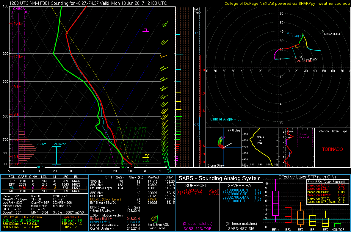
Friday’s 12z NAM model valid for 5:00pm on Monday in Central NJ shows a very favorable forecast sounding for severe weather with low-level rotation and fat CAPE (NEXLAB).
If this were to happen, there would be a severe weather threat with severe wind gusts, 1″ hail, and an isolated tornado — the SPC has a 15% (slight risk) out for the area on Monday. We are still leaning against a true “severe” weather threat and instead think this will be mainly a day with clusters of thunderstorms with heavy rain and some wind gusts up to 40mph with perhaps a shelf cloud somewhere — but if the NAM model were right, the severe threat would need to be taken more seriously. We’re not sure if the NAM’s “fatter” CAPE makes sense given the lack of an EML. But considering the trend has been to slow down the cold front thanks to the large West-Atlantic ridge and the fact that a slower cold front could mean more time for true instability to build due to more sunshine, and some of the ideas from the NAM cannot be ruled out.