-2")
Public Analysis: Severe Thunderstorms Ending This Evening, More Unsettled Weather Possible
Good Evening!
Over the past few hours or so we have seen the development of multiple rounds of strong to locally severe thunderstorms over much of the Northeast. These storms formed just ahead of a cold front located over portions of central Pennsylvania, with moderate to strong instability ahead of this front as well as some sufficient upper level dynamics superimposed over the Northeast. Some early morning storms were noted over portions of Northeast Pennsylvania, Northern New Jersey, and Southern Connecticut, but these storms were mainly heavy rain producers as the environment was not sufficiently destabilized from daytime heating yet.
At the time of this article, the last batch of strong thunderstorms were winding down over much of the area as the loss of surface heating in addition to the storms interacting with the marine air closer to the coast caused them to weaken quite a bit. From what we can tell as of right now, the vast majority of the storm reports from this afternoon were in the form of wind damage, although there have been very isolated reports that a tornado may have touched down in Berks County, Pennsylvania. This report will likely have to be confirmed by the NWS in the coming day. Otherwise, most of the wind damage was restricted to trees, which is quite common this time of year as saturated grounds and a full canopy of leaves can often lead to trees getting knocked onto property, or limbs being blow into power lines.
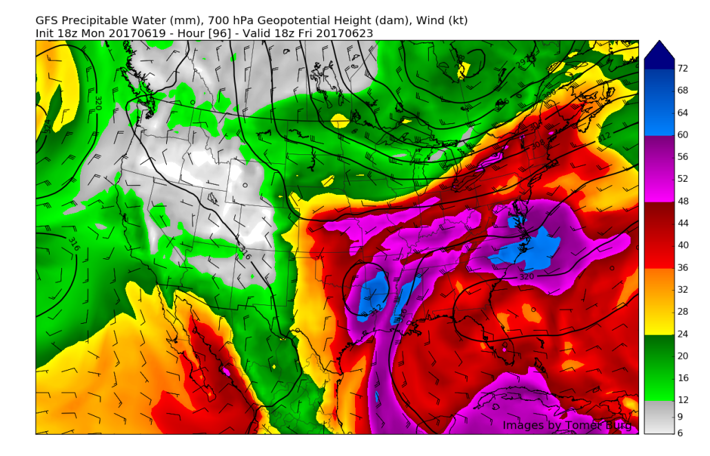
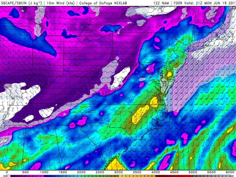
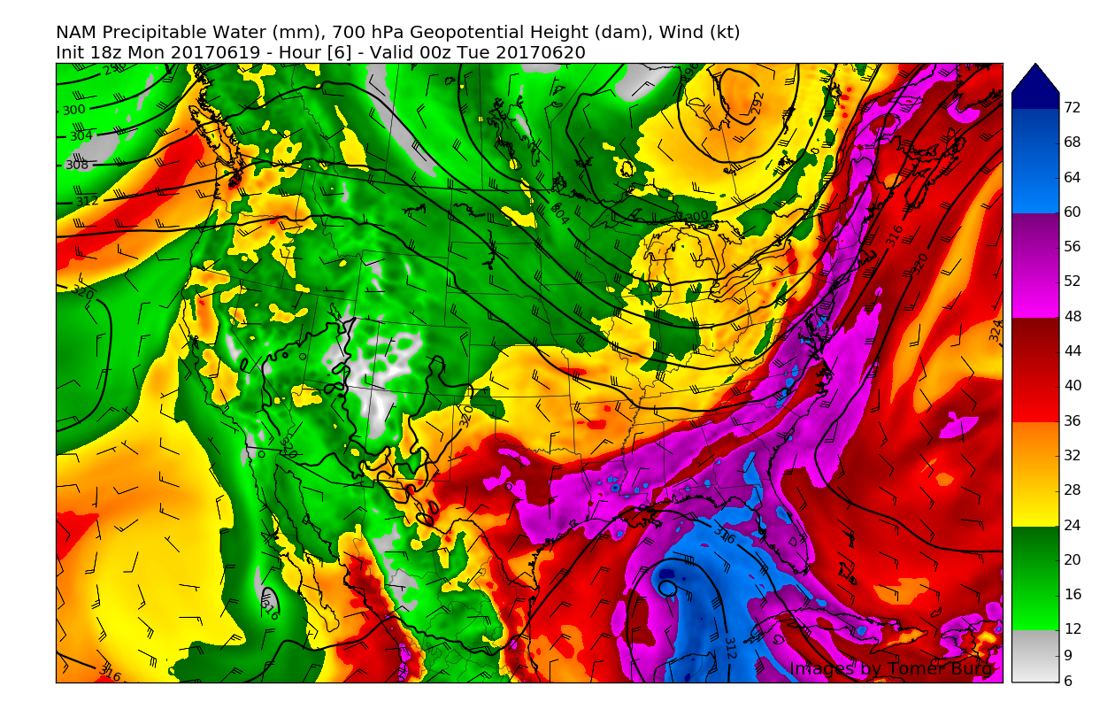
The main reason that today really lacked the “punch” of some of the more impressive severe weather events can be linked to two main things. First off, the amount of precipitatable water in the atmosphere was extremely high (on the order of 2″ in some places) and the lapse rates were quite low (the change of temperature as you get higher in altitude, which creates more substantial thunderstorm updrafts). This combination allowed the area to experience more tropical downpours than anything, as all the water would gather in the atmosphere, and due to the lack of strong updrafts, would quickly collapse to the surface, bringing very heavy rain and strong wind gusts. Another element that seems to have caused a rather lackluster event was the fact that we saw clouds develop early in the afternoon hours, which really limited the amount of surface heating that could occur before thunderstorms started to blossom over the area. Had there been more distinct clearing ahead of the main line, this event would have likely produces numerous/widespread wind damage reports over the region.
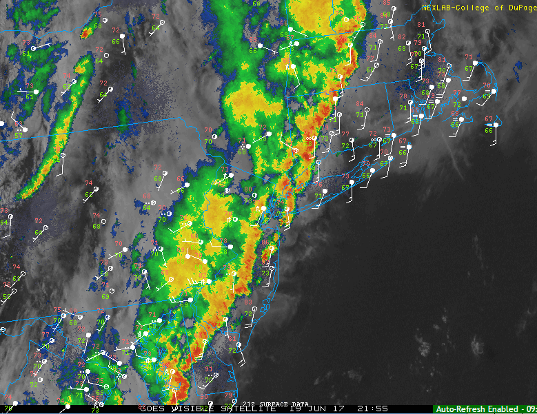
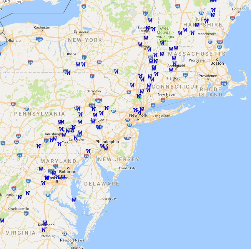
This evenings latest radar satellite and surface observations showing some heavy thunderstorms still over the region. These storms will likely be capable of producing torrential downpours and some gusty winds.
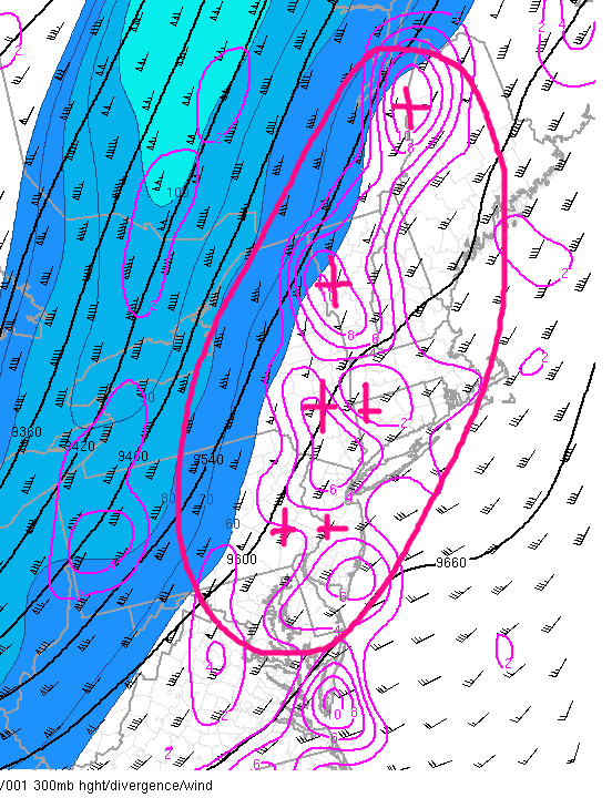
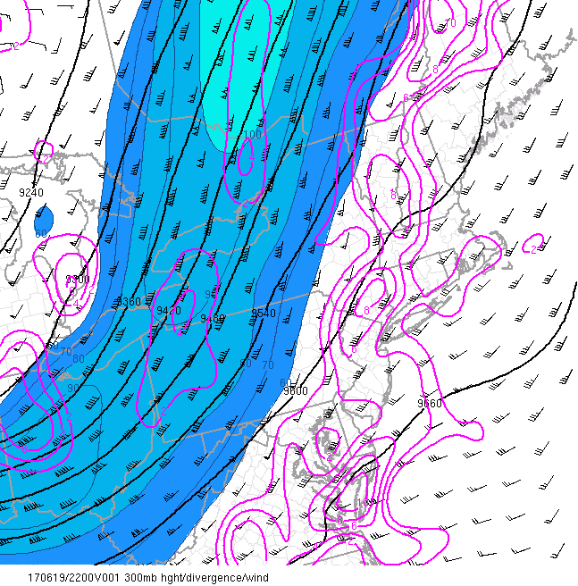
Storms will likely continue through the overnight hours for some southern and eastern locations as strong upper level divergence allows the strong tropical moisture to form heavy showers along any remaining convergence boundaries that are left over the region. The main threat from these showers and thunderstorms will likely be limited to very heavy rain and frequent lightning, though some strong winds cannot be completely ruled out just yet. Any lingering showers and thunderstorms should begin to gradually fade and shift eastward late this evening and into the very early morning hours as a cold front continues to press over the area.
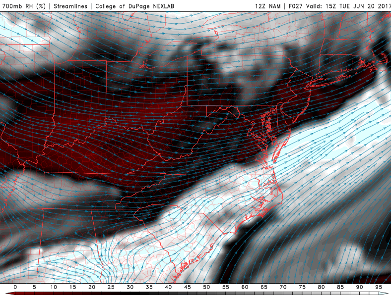
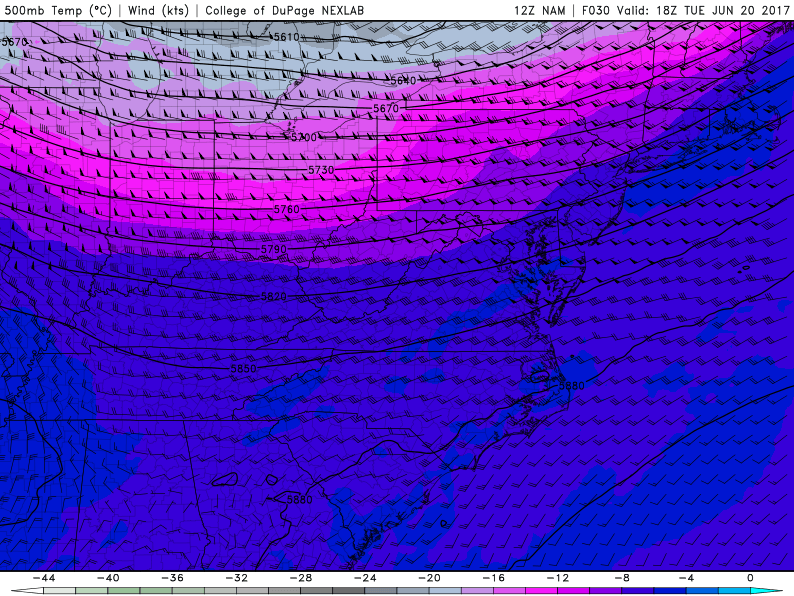
Tuesday morning should start off relatively dry as stout westerly winds usher in a much drier air-mass than what we have been dealing with over the past few days. With this direr air aloft in place, much of the area should experience mostly sunny conditions, with some gusty winds developing by the late morning and afternoon hours in response to a vertical temperature gradient brought about by a mid level trough passing to our north. Despite the gusty winds, tomorrow will still have some degree of humidity left to it, though it won’t be able to rise to levels even close to the past few days. These combined condition’s should allow temperatures to rise into the low to middle 80’s across the entire region.
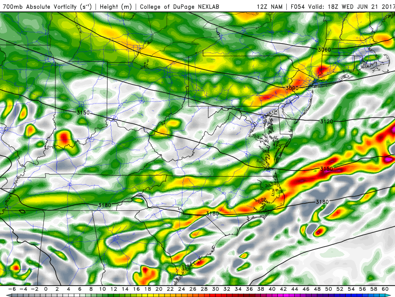
Wednesday will feature much of the same as the previous day, with early morning clear skies, giving way to some cumulus clouds likely developing by the mid afternoon hours. With some weak instability and moisture in place and a trigger to the north, we may see some scattered shower and thunderstorm development over the Northwestern portions of the region during the afternoon hours. The main threats from these showers and potential storms looks to be heavy rainfall and gusty winds. Highs on Wednesday will likely be able to climb at least into the upper 70’s, with lower to middle 80’s quite likely for inland locations.

This evenings latest Rapid Precision Model showing scattered showers, and possibly even a shallow thunderstorm or two developing during the afternoon hours on Wednesday (Courtesy of WSI)
Thursday and Beyond
An area of mid level ridging is likely to build over the region into Thursday and Friday, which should allow more sunny weather and warm temperatures to persist. Temperatures should easily be able to rise into the lower to middle 80’s for both days, with a chance at some afternoon showers and thunderstorms possible as moisture from down south begins to head towards our region.
This moisture is associated with what is currently “Potential Tropical Cyclone 3”-or the precursor to a tropical storm. This system was located over the central Gulf of Mexico as of 5pm EST with winds of 40 mph. This system is very large in nature and still lacks an organized low level circulation-though there are some indication that the system is trying to get its act together. This system will likely move north, and then west north west over the next 36-48 hours while lashing the Gulf Coast with copious amounts of heavy rain and gusty winds. By Wednesday or so, the system should be close to landfall along the Gulf Coast as a mid range tropical storm with winds likely around 50-60 mph.
After this system makes landfall along the Gulf Coast, the abundant moisture from this system will likely linger around the southeast for a day before a storm system moving through the Great Lakes drags a cold front through that area and potentially funnels that moisture towards our area in time for the weekend. Such a scenario could bring heavy tropical downpours on Saturday and Sunday, but at this time confidence is very low in such a scenario. We will continue to monitor this situation over the next few days and provide updates as needed!

This afternoons European model showing the potential tropical cyclones residual moisture being entrained along a cold front. There is a possibility that this moisture could eventually wind up over the Northeast later this weekend
For more information and posts like this one, make sure you sign up for Premium Forecasts — where multiple detailed articles, videos, and interactives are posted each day. Also, come interact with our staff and many other weather enthusiasts at 33andrain.com!
Have a great evening!
Steve Copertino