-2")
Weekly Outlook: Strong-Severe T-Storms Today…More Tropical Moisture By This Weekend?
A cold front associated with an upper-level trough over the Great Lakes, will be approaching the region, with some showers and thunderstorms by this evening A southwesterly flow ahead of this front, will cause dewpoints to rise into upper 60s and 70s this by afternoon. This will result in very warm, muggy day with temperatures reaching the mid-upper 80s away from the coast, with some sunshine this afternoon. Sea-breezes near the coast will keep temperatures from rising out of the upper 70s to lower 80s. More southerly winds will also lead high risk of rip current this afternoon along along south-shore facing beaches of NYC/Long Island and Central New Jersey.
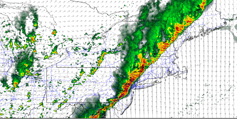
Instability is already building this morning, with the very warm, muggy airmass. With only little or no cap, some isolated to widely scattered showers and thunderstorms could begin to develop around the area, during by early this afternoon, especially as a pre-frontal trough and mid-level shortwave energy moves through. Then high-resolution model guidance indicates more organized line of showers and thunderstorms moving from west to east, as shear and forcing increases as a southwesterly low-level jet strengthens, ahead of the cold front moving closer to the region, later this afternoon and early this evening. Due to all these dynamics coming together for the region, the Storm Prediction Center has expanded the Enhanced Risk for severe t-storms into the more of the I-95 corridor, including New York City.
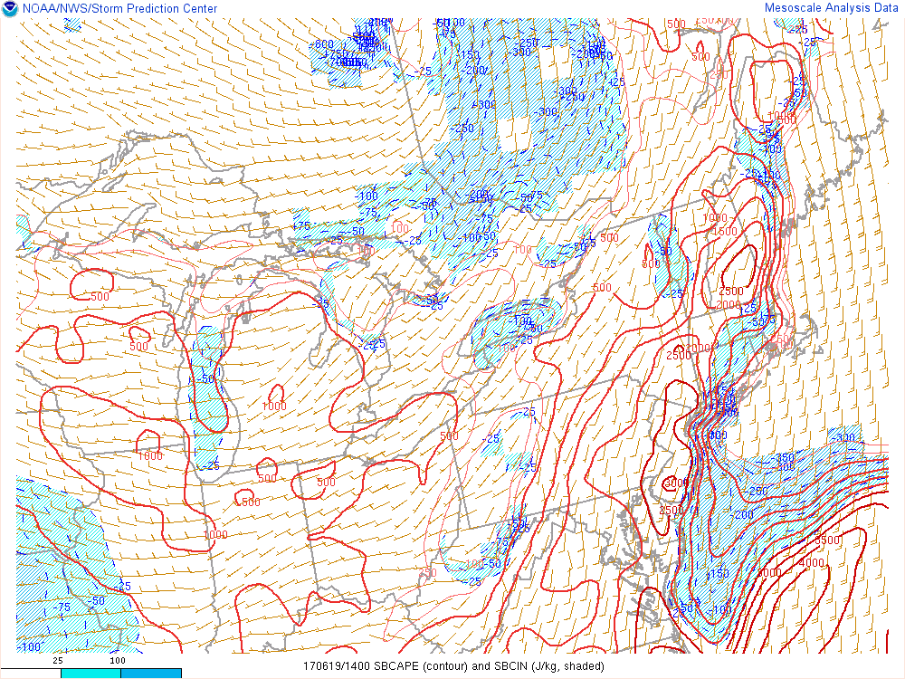
While mid-level lapse rates will be on the weaker side, MLCAPE will be between 1000 – 2000 J/kg and 0-6km bulk shear 30-40kts this afternoon and evening. This will support some strong to severe thunderstorms wind gusts possibly over 50 mph. Damaging straight-line winds will likely be the primary threat. Some large hail can’t be ruled out with high CAPE and shear environment. But this threat is reduced somewhat by high freezing levels and a lack of dry air in the mid-levels of atmosphere. There is also a threat some discrete supercells, ahead of the main line, that produce taller updrafts with larger hail. Some weak tornadoes are possible from these supercells , with low-level winds backing along the pre-frontal trough and low LCL heights, especially over parts of the Northeast Pennsylvania , Lower Hudson Valley and Northwest Connecticut.
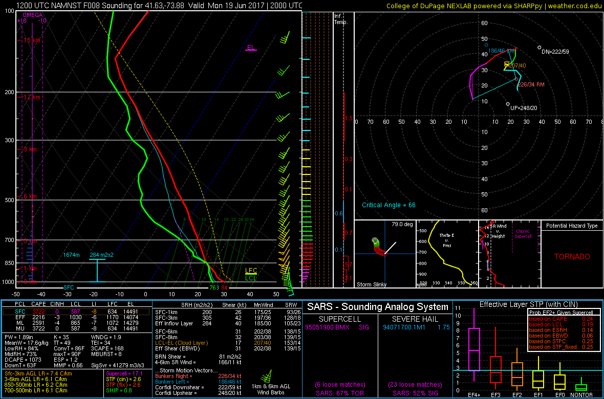
3km NAM sounding late this afternoon from Pougkeepsie,NY, showing high SBCAPE winds veering with height and low LCL heights supporting weak supercell tornado.
Thunderstorms are more likely weaken with more stable marine influence as they move into NYC/Long Island and other coastal areas. But some gusty winds and frequent lightning are still possible. High precipitable water values will support thunderstorms with torrential downpours. Winds also parallel to the cold front, and moisture convergence will likely lead to some training of showers and thunderstorms in parts of the region. Rainfall totals could exceed 2.00” leading to some localized flash flooding. For this reason, the National Weather Service has issued Flash Flood Watches for much of the region. Stay tuned for more updates, on our social media feeds on severe weather and heavy rainfall later today.
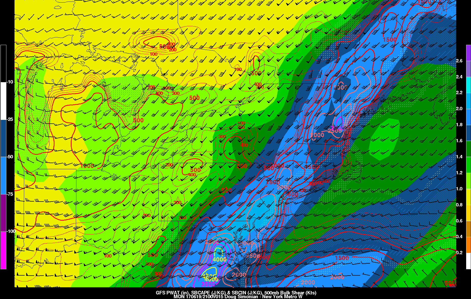
GFS model forecast with moderate to high instability and high precipitable water values supporting some severe weather and heavy rainfall this evening
Some strong lift , underneath the right entrance region of upper-level jet and moisture convergence ahead of cold will still cause some showers and thunderstorms will continue linger into the late evening and early overnight hours. Some heavy rainfall and localized flooding is still possible. But the severe weather threat will be diminishing with lowering instability. Then showers and thunderstorms will finally come to end late tonight, as the cold front and trough moves west to east across the region.
Weak high pressure will build over the region during the middle of this week. This will support more tranquil weather with some sunshine mixing with clouds each day, Tuesday and Wednesday. It will still remain very warm, with more downsloping westerly flow. But humidity will be much lower than today. A few scattered showers or thunderstorms are still possible as couple weak disturbances rotating around upper-level low or trough over Southeast Canada, move through the region, High temperatures each day will be in the lower to middle 80s. Which is closer to normal for third week of June.
More ridging is likely to build for over the region Thursday and into Friday, with more sunshine and high temperatures in the lower to middle 80s once again. However, we will be watching a tropical disturbance that will moving from Northwest Caribbean into Gulf of Mexico this week. This disturbance is being monitored by National Hurricane Center, for possible tropical or sub-tropical storm formation and could impact parts of the Gulf coast with some heavy rainfall and gusty winds later this week. An upper-level low over the Western Gulf of Mexico, will likely keep enough shear over this system, over next few days, only allowing for more gradual development into tropical or subtropical cyclone.
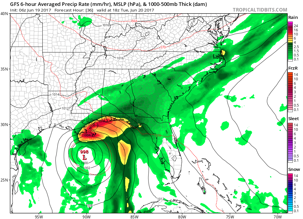
GFS model showing tropical or sub-tropical system impacting the Gulf coast with some heavy rain by Tuesday
Regardless of any further development, some model guidance indicates the remnants of this disturbance could interact with another cold front and upper-level trough approaching by Friday or during the weekend. If this occurs, period of heavy rainfall may be possible, with more tropical moisture coming from this disturbance. If there is less interaction, and tropical system remains further south, as the latest ECMWF model runs have been indicating, the potential for more widespread heavy rainfall will be lower here. But some unsettled weather with more scattered showers and thunderstorms are still possible, sometime over the weekend with cold front and upper-level trough. At this time, we don’t anticipate any washouts. But uncertainty is high on the amount of clouds and rainfall. Stay tuned for more forecast details, as they will likely become clearer, throughout the week.