-2")
Premium: Coastal Storm with Heavy Rainfall Possible Late Week
After the heat wave last week, more cooler, unsettled weather has returned to the region, as a trough moves through the Northeast. More clouds and onshore flow this week have kept high temperatures well below average over the region — it certainly doesn’t feel like the middle of summer. High pressure will support more pleasant, warmer weather on Wednesday. Then it looks like something we often see during the fall and winter months: a coastal storm with the potential for heavy rainfall by Thursday night and Friday and perhaps into this weekend as well. But uncertainty is still quite high with exactly how this storm evolve, its timing, and how much impact it will have on the region.
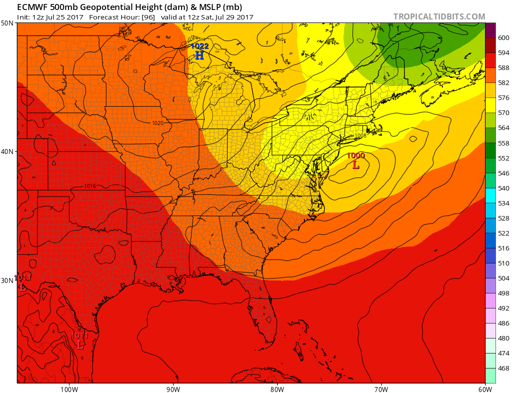
In general, model guidance shows a potent shortwave trough will be digging into the Great Lakes and Ohio Valley during Thursday night and Friday. Then this shortwave trough will begin to slow down and amplify as it moves eastward through the Mid-Atlantic region. This will cause an area of low pressure to develop and gradually organize into a coastal storm, along a baroclinic zone in the Lower Ohio Valley and Mid-Atlantic regions. Just based on this setup alone, at least some more unsettled and wetter weather appears likely later this week.
There are several important features in the overall large scale pattern that would be conducive for a storm to develop along East Coast, later this week. For one, there is +PNA ridge out over Northern Rockies and Upper Midwest — a normal precursor to some of our winter storms and Nor’Easters. This will support energy digging/sliding on the downstream side of this ridge before flatter wavelengths support a move heading eastward. Another one is that we have a -NAO ridge over Greenland, which indicates some high-latitude blocking will be present to perhaps to help slow down the flow and allow for more energy from the upper-level low over Southeast Canada to also begin to interact or phase with this storm system.
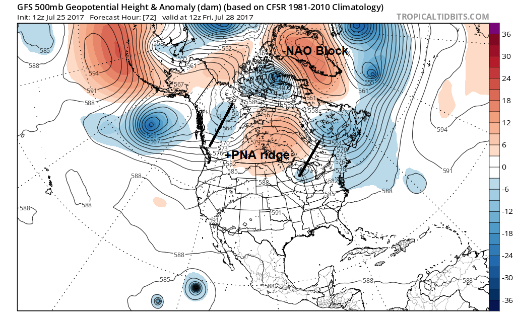
GFS model showing -NAO block over Greenland and +PNA ridge over Northern Rockies/Plains. Shortwave trough either side of the +PNA ridge
However, even with the blocking, there is also the possibility the pattern may still be a little too progressive for major East Coast amplification. There are some small features that are causing some perturbations in the pattern. This is leading to more model differences run to run or between each other, with the timing and amplitude of the storm system overall. For one, there is weaker, sheared shortwave energy running out ahead of this system that keeps heights flatter along the East Coast, preventing the shortwave energy from amplifying more and taking more of a negative tilt before reaching the coast. Another issue is more pacific shortwave energy is causing the +PNA ridge to flatten and progress eastward. These perturbations lead may lead to shorter wave spacing and less room for amplification along the coast. Instead, we may see a more disjointed coastal storm, with areas of stronger lift and instability supporting heavier rainfall, and more subsidence elsewhere — rather than a truly widespread, heavy rain event.
So for this reason we look at ensemble guidance for hints at what guidance may do in future runs, even in the shorter term. The latest run of the GFS ensembles shows most members are more tightly clustered with low pressure further south, which support stronger 12z operational GFS solution further south. However, sometimes the GFS ensemble members can be too “confident” relative to what the specific 12z data shows. In other words, they do not show as much spread as the chaotic nature of the pattern indicates.
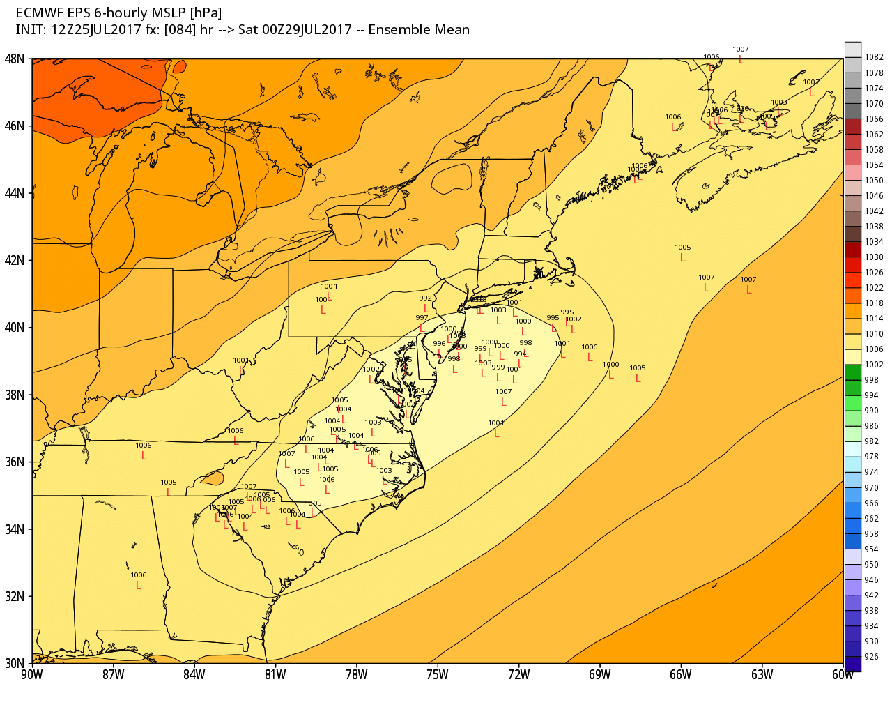
Thus, not surprisingly, the 12z ECMWF ensemble guidance today shows a larger spread members by Friday evening. One cluster of members show a surface low pressure just off the New Jersey and Long Island coasts. Another cluster is further south over the Virginia and North Carolina region. Then there is less spread there afterward. But overall this still indicates there may still be some significant shifts north and south in the guidance over next couple runs. The latest ECMWF ensemble still shows 1″ or more of rainfall for the southern half of region. Also, the latest 18z GFS Operational run shifted back north and slams the entire area with 1-3″ of rain on Friday into Saturday.
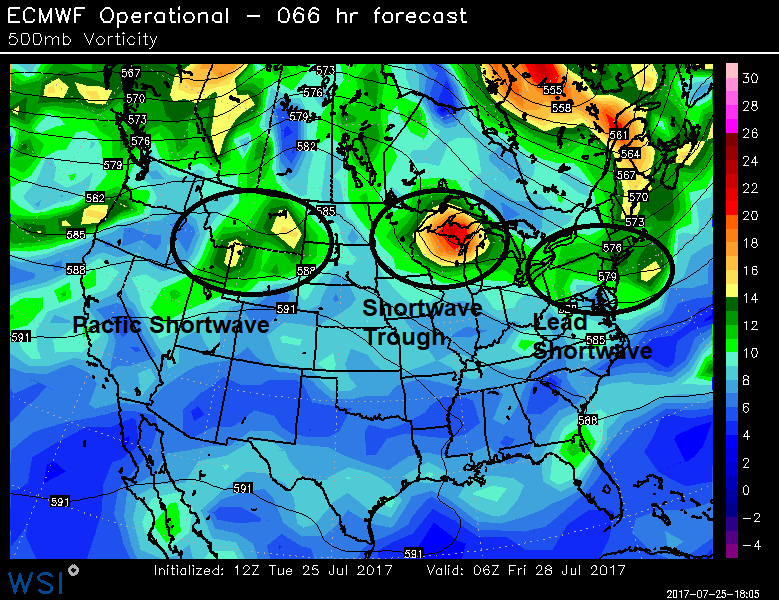
ECMWF model showing 500 voriticity and height fields over the CONUS Thursday night
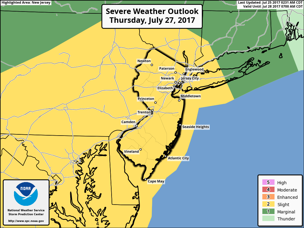
If this coastal storm does come together, there will be the potential for significant hazards such heavy rainfall and severe weather, over the Northeast and Mid-Atlantic region. This storm may be sandwiched in between two upper-level jet streaks to provide plenty of lift, contain some stronger winds fields, and also have access to a subtropical feed moisture coming of the Atlantic or Gulf of Mexico. But whether severe weather or heavy rain/flash flooding becomes the primary threat will largely depend on the track of the low. If the low tracks further into the NYC metro or north, more of the region will be in the warm sector, where more instability, shear and convergence will likely support more stronger t-storms with possibly some severe weather along and and south of a warm front that will further north as well this low track some over Mid-Atlantic region. For this reason, the Storm Prediction has already issued slight risk for much Mid-Atlantic region by Thursday night. But we think we instability will be too low to support more organized severe weather for much of the local region, especially give southern, slower trends at this time. On the other hand, if the low tracks further of south of NYC, there will be higher chance for more stratiform heavy rainfall over the region, with at least some localized minor flooding possible.
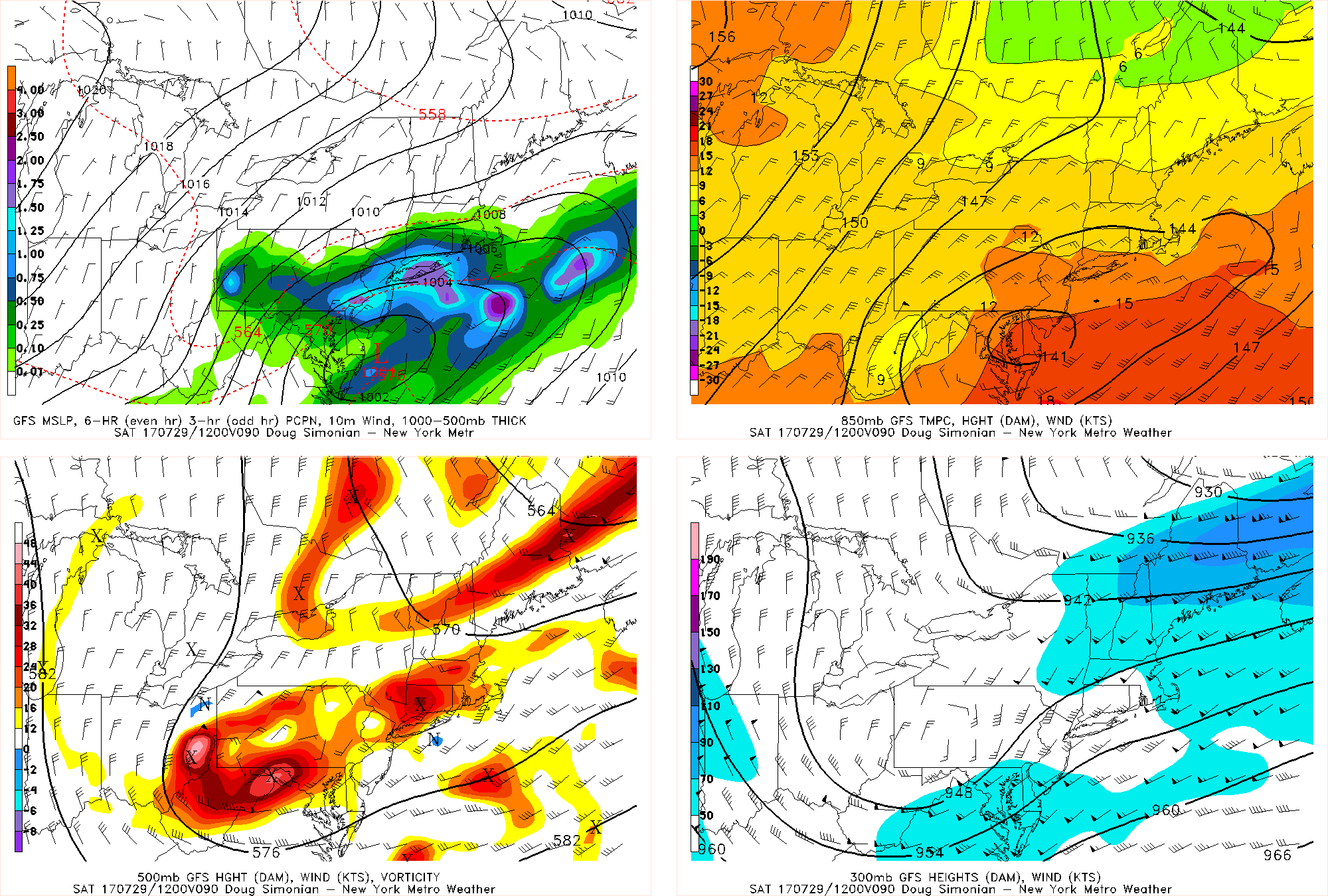
Today’s 18z GFS is well north of the 12z GFS, showing a large band of heavy rain to the north of a coastal low pressure system on Friday night.
At this point, we only watch for model and ensemble trends over the next few days. Most of the models will likely struggle to be handle these perturbations in pattern. The fact that some guidance shifted the coastal low from Thursday night into Friday in last night’s runs to Friday afternoon into Saturday on today’s runs shows the volatility to the pattern, and thus the uncertainty. Some convection may also lead to some global models like the GFS to show areas of heavy rainfall, especially north of the track. But given the potential for stronger thunderstorms more likely over lower parts of Mid-Atlantic region, this could result in more subsidence and lighter rainfall over parts of the local region. This means that the widespread heavy rain the GFS shows over the entire region may instead verify as more scattered/hit-or-miss heavy rain, with some regions getting heavy rain and flash flooding, and other localized areas getting much less rain.
Other the hand, if there is a stronger thermal gradient, we could see more dynamics such as isentropic lift and frontogenesis, supporting a band of very heavy rainfall north of the low track — regardless of the southern convection. This would increase the risk for more flash flooding in parts of the area. Stay tuned for more premium updates over the next few days as we iron out the details!