-2")
PM Update: Cooler risks linger, is there any change in sight?
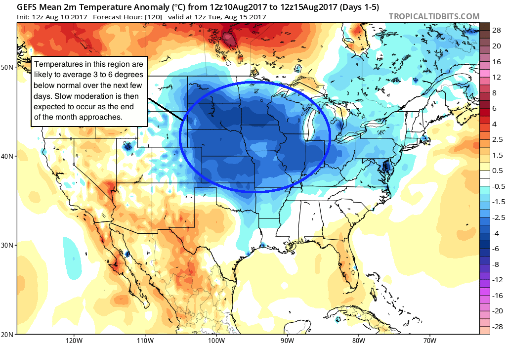
A well documented period of cooler than normal temperatures has taken over the Central and Eastern United states over the past week or two, especially from an anomaly standpoint. Many regions east of the Central and Southern Plains have observed temperatures 2 to 3 degrees below average over multiple days, which obviously leads to impacts both in terms of energy and crop. While precipitation patterns have been a bit more sporadic, the temperature forecast of near or below normal has been fairly consistent.
Forecast models today have remained steadfast with the overall pattern progression throughout the hemisphere over the next 10 or so days. This pattern will continue to support the presence of near or below normal temperatures for this time of year over the aforementioned areas. Much of this can be attributed to a stagnant pattern in the Pacific Ocean, which is allowing cooler than normal air to consistently sag southward from Canada into the Lower-48.
In addition to the Eastern Pacific Ocean, the pattern over Canada and the higher, arctic latitudes will support the mentioned temperature anomalies. Ridges of high pressure are forecast by all model guidance and ensembles to build into Central Canada and parts of the Arctic through next week. While seemingly harmless in terms of sensible weather impacts (they are ridges of high pressure after all), these act as highly disruptive features to the overall atmospheric flow.
As these ridges of high pressure, also known as “blocking” highs, build in to arctic regions, they displace the colder air which is typically situated over those areas, further south. In winter, blocking high pressures over Canada and the Arctic can cause significant outbreaks of cold air and movement of the Polar Vortex. In summer, the result in more temperate results — but still bring cooler than normal air into the Untied States.
What occurs this next week is no different. With high latitude blocking being signaled, forecast model guidance continues to suggest cooler than normal anomalies across the heart of the country, and we agree with the overall assessment. 5-Day Average temperature anomalies on both the GEFS and ECMWF ensembles continue to support moderate departures from normal on the order of 3 to 5 degrees.
As is the case with most things, however, this pattern looks likely to gradually break down. Timing this will be a tough task, but we can look to the oceans around us for some help. As troughs in the Pacific Ocean begin to pick up steam, and blocking ridges in the Atlantic begin to weaken, the colder air over the United States should modify and the ridging over the Western USA coast should roll eastward.
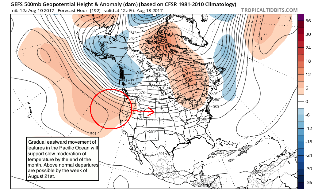
This supports the development of modifying temperatures in the Central and Eastern United States, gradually, during the week of August 21st. Our forecasters will continue to monitor the exact pattern evolution and how the temperature anomalies will evolve throughout the country during this time frame. Stay tuned for further updates over the next few days as this period comes into greater focus!
Trackbacks & Pingbacks
3descartes
Comments are closed.